SPC Severe Thunderstorm Watch 186

WW 186 SEVERE TSTM AR KS MO OK TX 290735Z – 291500Z
WW 0186 Image

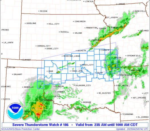
 URGENT - IMMEDIATE BROADCAST REQUESTED
Severe Thunderstorm Watch Number 186
NWS Storm Prediction Center Norman OK
235 AM CDT Tue Apr 29 2025 The NWS Storm Prediction Center has issued a * Severe Thunderstorm Watch for portions of Far Northwest Arkansas South-Central/Southeast Kansas Far Southwest Missouri Northern Oklahoma Far Northeast Texas Panhandle * Effective this Tuesday morning from 235 AM until 1000 AM CDT. * Primary threats include... Scattered large hail and isolated very large hail events to 2 inches in diameter possible Scattered damaging wind gusts to 70 mph possible SUMMARY...Thunderstorms are expected to develop across northwest OK
and the far northeast TX Panhandle in the vicinity of a cold front
progressing southward. This initial activity could pose a threat for
large hail. This development will likely grow upscale with an
attendant threat for damaging gusts as it moves eastward across
northern OK and south-central/southeast KS into far southwest MO and
far northwest AR. Some hail is possible within the stronger cells
across these areas as well. The severe thunderstorm watch area is approximately along and 60
statute miles north and south of a line from 95 miles west southwest
of Alva OK to 20 miles east northeast of Joplin MO. For a complete
depiction of the watch see the associated watch outline update
(WOUS64 KWNS WOU6). PRECAUTIONARY/PREPAREDNESS ACTIONS... REMEMBER...A Severe Thunderstorm Watch means conditions are
favorable for severe thunderstorms in and close to the watch area.
Persons in these areas should be on the lookout for threatening
weather conditions and listen for later statements and possible
warnings. Severe thunderstorms can and occasionally do produce
tornadoes. && AVIATION...A few severe thunderstorms with hail surface and aloft to
2 inches. Extreme turbulence and surface wind gusts to 60 knots. A
few cumulonimbi with maximum tops to 500. Mean storm motion vector
24035. ...Mosier 

Read more

SPC Tornado Watch 185

WW 185 TORNADO IA MN WI 290030Z – 290700Z
WW 0185 Image

 URGENT - IMMEDIATE BROADCAST REQUESTED
Tornado Watch Number 185
NWS Storm Prediction Center Norman OK
730 PM CDT Mon Apr 28 2025 The NWS Storm Prediction Center has issued a * Tornado Watch for portions of Far Northeast Iowa Extreme Southeast Minnesota Western and Northern Wisconsin * Effective this Monday night and Tuesday morning from 730 PM until 200 AM CDT. * Primary threats include... A few tornadoes likely with a couple intense tornadoes possible Scattered damaging winds likely with isolated significant gusts to 75 mph possible Scattered large hail likely with isolated very large hail events to 2 inches in diameter possible SUMMARY...A broken line of thunderstorms will continue to move
quickly east-northeastward this evening and into the early overnight
hours. A few tornadoes and scattered severe/damaging should be the
main threats with this activity, but some large hail may also occur
with any embedded supercells. The tornado watch area is approximately along and 50 statute miles
east and west of a line from 55 miles north northeast of Wausau WI
to 45 miles south of La Crosse WI. For a complete depiction of the
watch see the associated watch outline update (WOUS64 KWNS WOU5). PRECAUTIONARY/PREPAREDNESS ACTIONS... REMEMBER...A Tornado Watch means conditions are favorable for
tornadoes and severe thunderstorms in and close to the watch
area. Persons in these areas should be on the lookout for
threatening weather conditions and listen for later statements
and possible warnings. && OTHER WATCH INFORMATION...CONTINUE...WW 180...WW 181...WW
182...WW 183...WW 184... AVIATION...Tornadoes and a few severe thunderstorms with hail
surface and aloft to 2 inches. Extreme turbulence and surface wind
gusts to 65 knots. A few cumulonimbi with maximum tops to 500. Mean
storm motion vector 26040. ...Gleason 

Read more

SPC Severe Thunderstorm Watch 184

WW 184 SEVERE TSTM IA NE SD 282300Z – 290400Z
WW 0184 Image

 URGENT - IMMEDIATE BROADCAST REQUESTED
Severe Thunderstorm Watch Number 184
NWS Storm Prediction Center Norman OK
600 PM CDT Mon Apr 28 2025 The NWS Storm Prediction Center has issued a * Severe Thunderstorm Watch for portions of Northwest Iowa Northeast Nebraska Southeast South Dakota * Effective this Monday evening from 600 PM until 1100 PM CDT. * Primary threats include... Scattered large hail and isolated very large hail events to 2 inches in diameter possible Scattered damaging wind gusts to 70 mph possible SUMMARY...Multiple supercells along and near a cold front should
pose a threat for mainly large hail up to 1-2 inches in diameter
through the evening. Occasional severe/damaging winds may also
occur. The severe thunderstorm watch area is approximately along and 45
statute miles north and south of a line from 45 miles west southwest
of Yankton SD to 20 miles south of Spencer IA. For a complete
depiction of the watch see the associated watch outline update
(WOUS64 KWNS WOU4). PRECAUTIONARY/PREPAREDNESS ACTIONS... REMEMBER...A Severe Thunderstorm Watch means conditions are
favorable for severe thunderstorms in and close to the watch area.
Persons in these areas should be on the lookout for threatening
weather conditions and listen for later statements and possible
warnings. Severe thunderstorms can and occasionally do produce
tornadoes. && OTHER WATCH INFORMATION...CONTINUE...WW 180...WW 181...WW
182...WW 183... AVIATION...A few severe thunderstorms with hail surface and aloft to
2 inches. Extreme turbulence and surface wind gusts to 60 knots. A
few cumulonimbi with maximum tops to 500. Mean storm motion vector
26040. ...Gleason 

Read more

SPC Tornado Watch 183

WW 183 TORNADO IA KS MO NE 282200Z – 290500Z
WW 0183 Image

 URGENT - IMMEDIATE BROADCAST REQUESTED
Tornado Watch Number 183
NWS Storm Prediction Center Norman OK
500 PM CDT Mon Apr 28 2025 The NWS Storm Prediction Center has issued a * Tornado Watch for portions of Southwest into Central Iowa Northeast Kansas Northwest Missouri Far Southeast Nebraska * Effective this Monday afternoon from 500 PM until Midnight CDT. * Primary threats include... A few tornadoes likely with a couple intense tornadoes possible Scattered large hail and isolated very large hail events to 3 inches in diameter likely Scattered damaging winds likely with isolated significant gusts to 75 mph possible SUMMARY...Supercells are expected to continue developing this
evening while posing a threat for very large hail up to 2-3 inches
in diameter. A few tornadoes also appear likely, with a couple of
strong tornadoes possible with any sustained supercell. Scattered
severe/damaging winds with peak gusts to 65-75 mph may also occur. The tornado watch area is approximately along and 55 statute miles
east and west of a line from 45 miles north northwest of Des Moines
IA to 35 miles south southeast of Manhattan KS. For a complete
depiction of the watch see the associated watch outline update
(WOUS64 KWNS WOU3). PRECAUTIONARY/PREPAREDNESS ACTIONS... REMEMBER...A Tornado Watch means conditions are favorable for
tornadoes and severe thunderstorms in and close to the watch
area. Persons in these areas should be on the lookout for
threatening weather conditions and listen for later statements
and possible warnings. && OTHER WATCH INFORMATION...CONTINUE...WW 180...WW 181...WW 182... AVIATION...Tornadoes and a few severe thunderstorms with hail
surface and aloft to 3 inches. Extreme turbulence and surface wind
gusts to 65 knots. A few cumulonimbi with maximum tops to 500. Mean
storm motion vector 24035. ...Gleason 

Read more

Tornado Watch Issued for Northwest Texas, Big Country, Concho Valley

Tornado Watch Issued for Northwest Texas, Big Country, Concho Valley

The Storm Prediction Center has issued a tornado watch until 11 PM for Northwest Texas, Big Country, and the Concho Valley. Some cities included are Big Lake, San Angelo, Colorado City, Snyder, Spur, Abilene, Olney, Paducah, Quanah, Vernon, Wichita Falls, and Henrietta. Southwestern and Central Oklahoma are also included in the tornado watch. Storms will […]