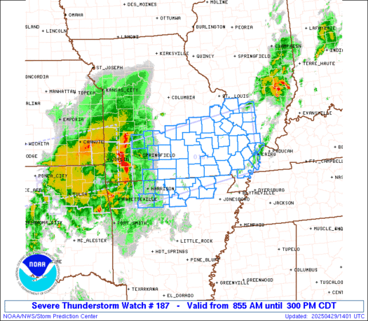
SPC Severe Thunderstorm Watch 188

WW 188 SEVERE TSTM IN KY OH WV 291630Z – 292300Z
WW 0188 Image

 URGENT - IMMEDIATE BROADCAST REQUESTED
Severe Thunderstorm Watch Number 188
NWS Storm Prediction Center Norman OK
1230 PM EDT Tue Apr 29 2025 The NWS Storm Prediction Center has issued a * Severe Thunderstorm Watch for portions of Southeast Indiana Northeast Kentucky Central and Southern Ohio Northern Panhandle of West Virginia * Effective this Tuesday afternoon and evening from 1230 PM until 700 PM EDT. * Primary threats include... Scattered damaging winds likely with isolated significant gusts to 75 mph possible Scattered large hail events to 1.5 inches in diameter possible A tornado or two possible SUMMARY...A fast-moving cluster of thunderstorms over southeast
Indiana is expected to remains intense and track across the watch
area through the afternoon. Locally damaging wind gusts are the
main concern. The severe thunderstorm watch area is approximately along and 55
statute miles north and south of a line from 35 miles west northwest
of Cincinnati OH to 15 miles north northeast of Wheeling WV. For a
complete depiction of the watch see the associated watch outline
update (WOUS64 KWNS WOU8). PRECAUTIONARY/PREPAREDNESS ACTIONS... REMEMBER...A Severe Thunderstorm Watch means conditions are
favorable for severe thunderstorms in and close to the watch area.
Persons in these areas should be on the lookout for threatening
weather conditions and listen for later statements and possible
warnings. Severe thunderstorms can and occasionally do produce
tornadoes. && OTHER WATCH INFORMATION...CONTINUE...WW 187... AVIATION...A few severe thunderstorms with hail surface and aloft to
1.5 inches. Extreme turbulence and surface wind gusts to 65 knots. A
few cumulonimbi with maximum tops to 500. Mean storm motion vector
25035. ...Hart 

Read more

Texas Weather About to Go Off — Days of Severe Storms & Flooding Ahead!

Texas Weather About to Go Off — Days of Severe Storms & Flooding Ahead!

Multiple rounds of flooding rainfall and severe thunderstorms will bring an active end to April across Texas, and the start of May will not be any different. Today’s risk for scattered to numerous severe thunderstorms extends from the Permian Basin in West Texas, through northwestern Texas, and eastward through Texoma and North Texas. Activity is […]

SPC Severe Thunderstorm Watch 187

WW 187 SEVERE TSTM AR IL MO 291355Z – 292000Z
WW 0187 Image

 URGENT - IMMEDIATE BROADCAST REQUESTED
Severe Thunderstorm Watch Number 187
NWS Storm Prediction Center Norman OK
855 AM CDT Tue Apr 29 2025 The NWS Storm Prediction Center has issued a * Severe Thunderstorm Watch for portions of Northern Arkansas Southwest Illinois Southern Missouri * Effective this Tuesday morning and afternoon from 855 AM until 300 PM CDT. * Primary threats include... Scattered damaging winds likely with isolated significant gusts to 75 mph possible Scattered large hail events to 1.5 inches in diameter possible A tornado or two possible SUMMARY...A fast-moving line of thunderstorms over southwest
Missouri and northwest Arkansas will track eastward across the watch
today. Locally damaging wind gusts and hail are possible with this
activity. The severe thunderstorm watch area is approximately along and 65
statute miles north and south of a line from 40 miles northwest of
Harrison AR to 20 miles south of Carbondale IL. For a complete
depiction of the watch see the associated watch outline update
(WOUS64 KWNS WOU7). PRECAUTIONARY/PREPAREDNESS ACTIONS... REMEMBER...A Severe Thunderstorm Watch means conditions are
favorable for severe thunderstorms in and close to the watch area.
Persons in these areas should be on the lookout for threatening
weather conditions and listen for later statements and possible
warnings. Severe thunderstorms can and occasionally do produce
tornadoes. && OTHER WATCH INFORMATION...CONTINUE...WW 186... AVIATION...A few severe thunderstorms with hail surface and aloft to
1.5 inches. Extreme turbulence and surface wind gusts to 65 knots. A
few cumulonimbi with maximum tops to 500. Mean storm motion vector
25035. ...Hart 

Read more