Exclusive video reveals secretive Area 51 military base as seen from space

New 4K satellite imagery has been released that shows one of the most secretive locations in America â Area 51.
24/7 Tornado Newsfeed
New 4K satellite imagery has been released that shows one of the most secretive locations in America â Area 51.

Firefighters in New Jersey are still working to extinguish the largest wildfire the Garden State has seen in years, and a dramatic new video shows just how close the flames and smoke came to homes in Ocean County.

With severe weather season in full swing, thunderstorms continue to pound the Midwest with damaging winds and some substantial hail.

Top weather news for Thursday, April 24, 2025: The Jones Road Wildfire could be one of the largest wildfires that New Jersey has seen in years after it torched more than 10,000 acres in less than a day, officials said, warning that the flames could rage for days.
No watches are valid as of Thu Apr 24 10:02:02 UTC 2025.
Pop-up showers today, with lower rain chances by the weekend.
WW 165 SEVERE TSTM OK TX 240420Z – 241000Z 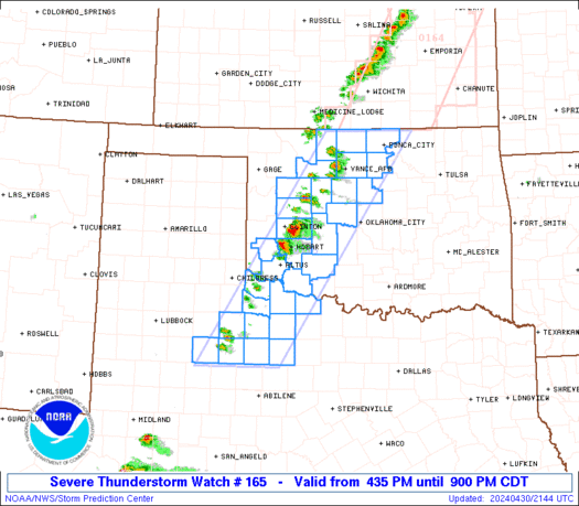
 URGENT - IMMEDIATE BROADCAST REQUESTED
Severe Thunderstorm Watch Number 165
NWS Storm Prediction Center Norman OK
1120 PM CDT Wed Apr 23 2025 The NWS Storm Prediction Center has issued a * Severe Thunderstorm Watch for portions of Southwest Oklahoma Western North Texas * Effective this Wednesday night and Thursday morning from 1120 PM until 500 AM CDT. * Primary threats include... Scattered damaging wind gusts to 70 mph possible Isolated large hail events to 1.5 inches in diameter possible SUMMARY...A cluster of storms should continue east-southeastward
into southwest Oklahoma and western North Texas early in the
overnight, with some continued potential for severe-caliber wind
gusts and sporadic hail. The severe thunderstorm watch area is approximately along and 70
statute miles north and south of a line from 50 miles southwest of
Altus OK to 45 miles south southeast of Altus OK. For a complete
depiction of the watch see the associated watch outline update
(WOUS64 KWNS WOU5). PRECAUTIONARY/PREPAREDNESS ACTIONS... REMEMBER...A Severe Thunderstorm Watch means conditions are
favorable for severe thunderstorms in and close to the watch area.
Persons in these areas should be on the lookout for threatening
weather conditions and listen for later statements and possible
warnings. Severe thunderstorms can and occasionally do produce
tornadoes. && OTHER WATCH INFORMATION...CONTINUE...WW 164... AVIATION...A few severe thunderstorms with hail surface and aloft to
1.5 inches. Extreme turbulence and surface wind gusts to 60 knots. A
few cumulonimbi with maximum tops to 500. Mean storm motion vector
27025. ...Guyer

The past six months have proven to be a tale of two Californias when it comes to atmospheric river events. While Northern California experienced a surge in precipitation and significant impacts, Southern California remained largely dry, raising concerns about the upcoming fire season. The strongest atmospheric river struck in November, bringing widespread flooding, record-breaking rainfall, and hurricane-force winds to the northern part of the Golden State.

Another comet has fascinated skygazers but has already sung its swan song after approaching the Sun.