Eaglets killed when 75-mph windstorm knocks bald eagle nest out of tree

Three baby bald eagles were killed over the weekend when their nest was blown out of a tree during a sudden windstorm.
24/7 Tornado Newsfeed
Three baby bald eagles were killed over the weekend when their nest was blown out of a tree during a sudden windstorm.

A powerful spring storm system is poised to sweep across the heartland next week and produce severe weather from Tulsa and Oklahoma City, northward to Minneapolis and Duluth. The greatest risk area appears to focus on Iowa and nearby Kansas, Minnesota and Wisconsin, where an intensifying low-level jet could enhance the intensity and coverage of storms.
WW 167 TORNADO OK TX 242035Z – 250400Z 
 URGENT - IMMEDIATE BROADCAST REQUESTED
Tornado Watch Number 167
NWS Storm Prediction Center Norman OK
335 PM CDT Thu Apr 24 2025 The NWS Storm Prediction Center has issued a * Tornado Watch for portions of Oklahoma Panhandle Texas Panhandle and South Plains * Effective this Thursday afternoon and evening from 335 PM until 1100 PM CDT. * Primary threats include... A couple tornadoes possible Scattered large hail and isolated very large hail events to 4 inches in diameter likely Isolated damaging wind gusts to 70 mph possible SUMMARY...Widely scattered thunderstorms are forecast to rapidly
develop this afternoon into the early evening. Environmental shear
and buoyancy combinations strongly favor intense, discrete
supercells. Large to giant hail will be probable with any
supercell. The tornado risk will likely focus for a few hours
during the early evening near a residual outflow boundary draped
over parts of the Watch area. The tornado watch area is approximately along and 60 statute miles
east and west of a line from 30 miles northeast of Guymon OK to 60
miles southeast of Lubbock TX. For a complete depiction of the watch
see the associated watch outline update (WOUS64 KWNS WOU7). PRECAUTIONARY/PREPAREDNESS ACTIONS... REMEMBER...A Tornado Watch means conditions are favorable for
tornadoes and severe thunderstorms in and close to the watch
area. Persons in these areas should be on the lookout for
threatening weather conditions and listen for later statements
and possible warnings. && OTHER WATCH INFORMATION...CONTINUE...WW 166... AVIATION...Tornadoes and a few severe thunderstorms with hail
surface and aloft to 4 inches. Extreme turbulence and surface wind
gusts to 60 knots. A few cumulonimbi with maximum tops to 550. Mean
storm motion vector 29015. ...Smith

Multiple zones of severe thunderstorm potential are underway or about to develop across Texas. For simplicity’s sake, I’ll divide them up into regions. Central Texas, Brazos Valley, and Southeast Texas A line of storms is moving southeast into the aforementioned regions. These storms produced 67 MPH winds in Waco, along with flooding from heavy rain […]
WW 166 SEVERE TSTM TX 241955Z – 250100Z 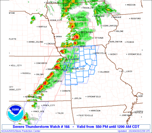
 URGENT - IMMEDIATE BROADCAST REQUESTED
Severe Thunderstorm Watch Number 166
NWS Storm Prediction Center Norman OK
255 PM CDT Thu Apr 24 2025 The NWS Storm Prediction Center has issued a * Severe Thunderstorm Watch for portions of Central into East Texas * Effective this Thursday afternoon and evening from 255 PM until 800 PM CDT. * Primary threats include... Scattered damaging wind gusts to 70 mph possible Isolated large hail events to 1.5 inches in diameter possible SUMMARY...A linear cluster of strong to severe thunderstorms will
likely continue east across much of the Watch area this afternoon
into the early evening. Severe gusts 60-70 mph appear to be the
primary hazard, but large hail may accompany the stronger cells on
the southwestern flank of the thunderstorm band. The severe thunderstorm watch area is approximately along and 50
statute miles north and south of a line from 35 miles west of Temple
TX to 25 miles east of Lufkin TX. For a complete depiction of the
watch see the associated watch outline update (WOUS64 KWNS WOU6). PRECAUTIONARY/PREPAREDNESS ACTIONS... REMEMBER...A Severe Thunderstorm Watch means conditions are
favorable for severe thunderstorms in and close to the watch area.
Persons in these areas should be on the lookout for threatening
weather conditions and listen for later statements and possible
warnings. Severe thunderstorms can and occasionally do produce
tornadoes. && AVIATION...A few severe thunderstorms with hail surface and aloft to
1.5 inches. Extreme turbulence and surface wind gusts to 60 knots. A
few cumulonimbi with maximum tops to 500. Mean storm motion vector
28030. ...Smith

Scientists found that a "cap" of bubbles and magma stands between the magma reservoir underneath Yellowstone National Park and a volcanic eruption.

Katherine Prandi posted a video of a large shark swimming by her while diving near Murrells Inlet.

Scattered thunderstorms reached Texoma and North Texas this morning, somewhat contradicting my forecast video posted yesterday morning. These storms have continued into the late morning, now extending from the eastern Big Country to southern areas of the D/FW Metroplex. It seems likely that storms will continue to develop further south this afternoon into southern North […]