Mother dies in fall while hiking with her children at Massachusetts state park
A 49-year-old mother was killed in a fall while visiting a state park with her children on Wednesday.
24/7 Tornado Newsfeed
A 49-year-old mother was killed in a fall while visiting a state park with her children on Wednesday.

LIVE Texas Severe Weather Coverage {Baldy-in-Chief David Reimer @texasstormchasers} for April 24, 2025. We will focus on the most intense storms to keep you informed, without the hype, and ahead of the storm. Remember, knowledge is power – and with that, you are already in better shape than those who may not know storms are […]

A baby manatee was rescued in southern Florida on Tuesday after it had become separated from its mother.
WW 170 SEVERE TSTM KS OK 242155Z – 250500Z 
 URGENT - IMMEDIATE BROADCAST REQUESTED
Severe Thunderstorm Watch Number 170
NWS Storm Prediction Center Norman OK
455 PM CDT Thu Apr 24 2025 The NWS Storm Prediction Center has issued a * Severe Thunderstorm Watch for portions of Southwest and South-Central Kansas Far Northern Oklahoma * Effective this Thursday afternoon from 455 PM until Midnight CDT. * Primary threats include... Scattered large hail and isolated very large hail events to 2 inches in diameter possible Scattered damaging wind gusts to 70 mph possible A tornado or two possible SUMMARY...Storms will persist with additional development along the
Kansas-Oklahoma border vicinity, as well as other parts of
west-central Kansas through early evening. Additional storms may
eventually move into the region from eastern Colorado, while MCS
development could occur along the Kansas/Oklahoma border vicinity. The severe thunderstorm watch area is approximately along and 50
statute miles north and south of a line from 70 miles west of Garden
City KS to 35 miles northeast of Medicine Lodge KS. For a complete
depiction of the watch see the associated watch outline update
(WOUS64 KWNS WOU0). PRECAUTIONARY/PREPAREDNESS ACTIONS... REMEMBER...A Severe Thunderstorm Watch means conditions are
favorable for severe thunderstorms in and close to the watch area.
Persons in these areas should be on the lookout for threatening
weather conditions and listen for later statements and possible
warnings. Severe thunderstorms can and occasionally do produce
tornadoes. && OTHER WATCH INFORMATION...CONTINUE...WW 166...WW 167...WW
168...WW 169... AVIATION...A few severe thunderstorms with hail surface and aloft to
2 inches. Extreme turbulence and surface wind gusts to 60 knots. A
few cumulonimbi with maximum tops to 500. Mean storm motion vector
25025. ...Guyer
WW 169 SEVERE TSTM CO 242140Z – 250400Z 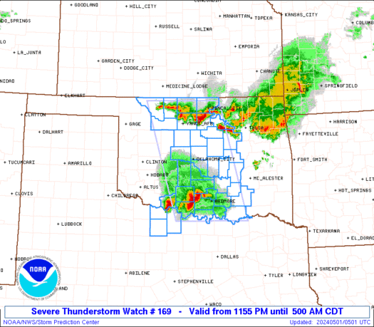
 URGENT - IMMEDIATE BROADCAST REQUESTED
Severe Thunderstorm Watch Number 169
NWS Storm Prediction Center Norman OK
440 PM CDT Thu Apr 24 2025 The NWS Storm Prediction Center has issued a * Severe Thunderstorm Watch for portions of Eastern Colorado * Effective this Thursday afternoon and evening from 440 PM until 1100 PM CDT. * Primary threats include... Scattered large hail likely with isolated very large hail events to 2 inches in diameter possible Isolated damaging wind gusts to 70 mph possible A tornado or two possible SUMMARY...Additional strong/severe storm development is expected to
occur through late afternoon, especially across
east-central/southeast Colorado. This will include a combo of
multicells and a few supercells with large hail expected to be the
most probable severe hazard. The severe thunderstorm watch area is approximately along and 85
statute miles north and south of a line from 10 miles west northwest
of Pueblo CO to 35 miles east of Lamar CO. For a complete depiction
of the watch see the associated watch outline update (WOUS64 KWNS
WOU9). PRECAUTIONARY/PREPAREDNESS ACTIONS... REMEMBER...A Severe Thunderstorm Watch means conditions are
favorable for severe thunderstorms in and close to the watch area.
Persons in these areas should be on the lookout for threatening
weather conditions and listen for later statements and possible
warnings. Severe thunderstorms can and occasionally do produce
tornadoes. && OTHER WATCH INFORMATION...CONTINUE...WW 166...WW 167...WW 168... AVIATION...A few severe thunderstorms with hail surface and aloft to
2 inches. Extreme turbulence and surface wind gusts to 60 knots. A
few cumulonimbi with maximum tops to 500. Mean storm motion vector
29025. ...Guyer
WW 168 SEVERE TSTM NM TX 242100Z – 250300Z 
 URGENT - IMMEDIATE BROADCAST REQUESTED
Severe Thunderstorm Watch Number 168
NWS Storm Prediction Center Norman OK
400 PM CDT Thu Apr 24 2025 The NWS Storm Prediction Center has issued a * Severe Thunderstorm Watch for portions of Far Southeast New Mexico West Texas * Effective this Thursday afternoon and evening from 400 PM until 1000 PM CDT. * Primary threats include... Scattered large hail and isolated very large hail events to 3 inches in diameter possible Scattered damaging wind gusts to 70 mph possible SUMMARY...Isolated thunderstorms are forecast to develop through the
late afternoon and early evening. The stronger storms will likely
become supercellular and pose mainly a threat for large to very
large hail. The severe thunderstorm watch area is approximately along and 70
statute miles east and west of a line from 65 miles north northwest
of Big Spring TX to 25 miles west southwest of Dryden TX. For a
complete depiction of the watch see the associated watch outline
update (WOUS64 KWNS WOU8). PRECAUTIONARY/PREPAREDNESS ACTIONS... REMEMBER...A Severe Thunderstorm Watch means conditions are
favorable for severe thunderstorms in and close to the watch area.
Persons in these areas should be on the lookout for threatening
weather conditions and listen for later statements and possible
warnings. Severe thunderstorms can and occasionally do produce
tornadoes. && OTHER WATCH INFORMATION...CONTINUE...WW 166...WW 167... AVIATION...A few severe thunderstorms with hail surface and aloft to
3 inches. Extreme turbulence and surface wind gusts to 60 knots. A
few cumulonimbi with maximum tops to 500. Mean storm motion vector
31015. ...Smith
")
 Embark on an exhilarating journey with the Texas Storm Chasers as they set out to document the potentially intense and awe-inspiring supercell thunderstorms sweeping through the Texas Panhandle and the expansive region of West Texas. Accomplished storm chasers Adam Lucio and Chelsea Burnett are poised to bring you directly into the heart of the […]