Month: April 2025
SPC Severe Thunderstorm Watch 173
WW 173 SEVERE TSTM NM TX 251940Z – 260300Z 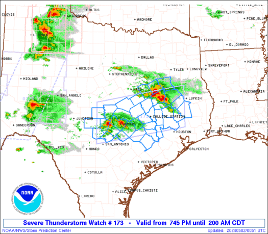
 URGENT - IMMEDIATE BROADCAST REQUESTED
Severe Thunderstorm Watch Number 173
NWS Storm Prediction Center Norman OK
240 PM CDT Fri Apr 25 2025 The NWS Storm Prediction Center has issued a * Severe Thunderstorm Watch for portions of Southeast New Mexico West Texas * Effective this Friday afternoon and evening from 240 PM until 1000 PM CDT. * Primary threats include... Scattered large hail and isolated very large hail events to 3 inches in diameter likely Isolated damaging wind gusts to 70 mph possible A tornado or two possible SUMMARY...Isolated thunderstorms are forecast to develop and
intensify this afternoon into the evening. Initially storms will
likely focus near the higher terrain but will eventually move east
into lower elevations. The stronger storms will likely become
supercells with both left and right splitting supercells possible. Large to very large hail will be the primary risk with these storms. A tornado is possible during the early evening as low-level winds
strengthen. The severe thunderstorm watch area is approximately along and 60
statute miles east and west of a line from 55 miles east northeast
of Carlsbad NM to 45 miles southwest of Fort Stockton TX. For a
complete depiction of the watch see the associated watch outline
update (WOUS64 KWNS WOU3). PRECAUTIONARY/PREPAREDNESS ACTIONS... REMEMBER...A Severe Thunderstorm Watch means conditions are
favorable for severe thunderstorms in and close to the watch area.
Persons in these areas should be on the lookout for threatening
weather conditions and listen for later statements and possible
warnings. Severe thunderstorms can and occasionally do produce
tornadoes. && OTHER WATCH INFORMATION...CONTINUE...WW 172... AVIATION...A few severe thunderstorms with hail surface and aloft to
3 inches. Extreme turbulence and surface wind gusts to 60 knots. A
few cumulonimbi with maximum tops to 500. Mean storm motion vector
27010. ...Smith
SPC Tornado Watch 172
WW 172 TORNADO NM TX 251855Z – 260300Z 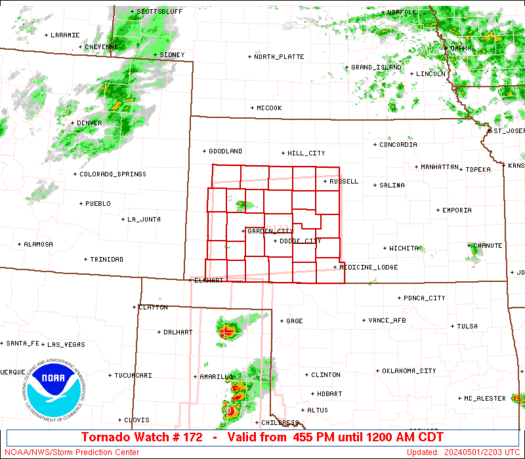
 URGENT - IMMEDIATE BROADCAST REQUESTED
Tornado Watch Number 172
NWS Storm Prediction Center Norman OK
155 PM CDT Fri Apr 25 2025 The NWS Storm Prediction Center has issued a * Tornado Watch for portions of Eastern New Mexico Texas Panhandle and South Plains * Effective this Friday afternoon and evening from 155 PM until 1000 PM CDT. * Primary threats include... A few tornadoes and a couple intense tornadoes possible Scattered large hail and isolated very large hail events to 4 inches in diameter likely Isolated damaging wind gusts to 70 mph possible SUMMARY...Scattered thunderstorms are forecast to develop this
afternoon and evening. Once storms develop, the stronger storms
will likely evolve into intense supercells capable of large to giant
hail. The risk for tornadoes will probably maximize late this
afternoon into the evening as low-level winds strengthen. A strong
tornado is possible. The tornado watch area is approximately along and 85 statute miles
north and south of a line from 55 miles south southwest of Cannon
Afb NM to 25 miles northeast of Childress TX. For a complete
depiction of the watch see the associated watch outline update
(WOUS64 KWNS WOU2). PRECAUTIONARY/PREPAREDNESS ACTIONS... REMEMBER...A Tornado Watch means conditions are favorable for
tornadoes and severe thunderstorms in and close to the watch
area. Persons in these areas should be on the lookout for
threatening weather conditions and listen for later statements
and possible warnings. && AVIATION...Tornadoes and a few severe thunderstorms with hail
surface and aloft to 4 inches. Extreme turbulence and surface wind
gusts to 60 knots. A few cumulonimbi with maximum tops to 550. Mean
storm motion vector 27010. ...Smith
West Texas Braces for More DVD-Size Hail & Tornadoes

Scattered thunderstorms will develop after 4 PM in the Texas Panhandle, West Texas, and the Permian Basin. Like yesterday, we expect the most intense storms to produce giant hail up to or exceeding DVD size (5 inches in diameter), localized damaging wind gusts of 60 to 80 MPH, and an increasing threat of tornadoes closer […]
See it: Rare horseshoe vortex cloud captivates Oklahoma sky

Thunderstorms above Oklahoma sculpted a seldom-seen spectacle in the sky Friday morning.
See it: Fireball lights up Alaskan skies in broad daylight

A meteor was captured on an Alaska State Trooper's dashcam as it hurtled through Earth's atmosphere in broad daylight.
New Jersey fire danger spikes Friday as Jones Road Fire scorches over 15,000 acres

New Jersey faces an increased risk of rapid fire spreading on Friday as firefighters continue battling the 15,000-acre Jones Road fire.
250 pounds of stranded fish rescued from Buffalo Trace Distillery after historic Kentucky flood

The historic flooding in Frankfort, Kentucky, led to an unexpected rescue at Buffalo Trace Distillery.
Iconic ‘Tree of Life’ that defied gravity for years along Washington beach takes last stand

The âTree of Lifeâ in Olympic National Park has become a symbol of resilience over the years, but recent photos show that this bastion of beating the odds may be coming to its end.