SAN ANTONIO’S FORECAST: Muggy and warm weekend, storm chances peak midweek
Near 90° for weekend Fiesta festivities
24/7 Tornado Newsfeed
Near 90° for weekend Fiesta festivities
No watches are valid as of Sat Apr 26 10:02:02 UTC 2025.

NASAâs Mars Reconnaissance Orbiter captured an image of the Curiosity rover driving through the Gale Crater. The spacecraft entered Marsâ orbit in 2006 and could continue to operate through 2029.
WW 174 SEVERE TSTM TX 260300Z – 260900Z 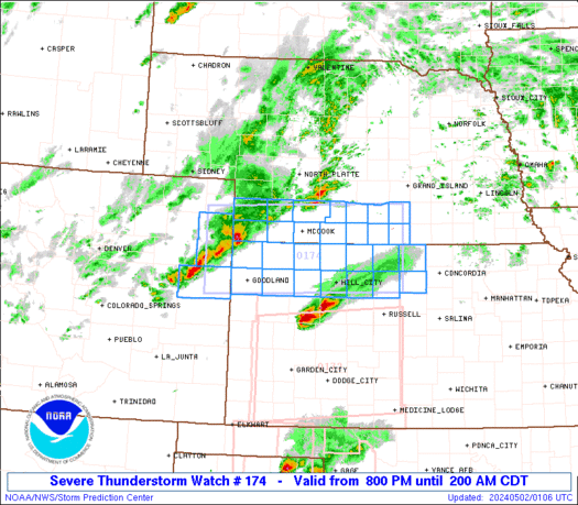
 URGENT - IMMEDIATE BROADCAST REQUESTED
Severe Thunderstorm Watch Number 174
NWS Storm Prediction Center Norman OK
1000 PM CDT Fri Apr 25 2025 The NWS Storm Prediction Center has issued a * Severe Thunderstorm Watch for portions of Texas Panhandle and South Plains * Effective this Friday night and Saturday morning from 1000 PM until 400 AM CDT. * Primary threats include... Scattered damaging wind gusts to 70 mph possible Scattered large hail events to 1.5 inches in diameter possible A tornado or two possible SUMMARY...Clusters of storms will continue through late evening into
the overnight, with some additional organization possible,
potentially including Mesoscale Convective System development.
Periodic large hail will remain possible along with locally damaging
winds as the primary hazards into the overnight, as storms progress
generally eastward. The severe thunderstorm watch area is approximately along and 60
statute miles north and south of a line from 75 miles west of
Plainview TX to 20 miles southeast of Childress TX. For a complete
depiction of the watch see the associated watch outline update
(WOUS64 KWNS WOU4). PRECAUTIONARY/PREPAREDNESS ACTIONS... REMEMBER...A Severe Thunderstorm Watch means conditions are
favorable for severe thunderstorms in and close to the watch area.
Persons in these areas should be on the lookout for threatening
weather conditions and listen for later statements and possible
warnings. Severe thunderstorms can and occasionally do produce
tornadoes. && OTHER WATCH INFORMATION...CONTINUE...WW 172...WW 173... AVIATION...A few severe thunderstorms with hail surface and aloft to
1.5 inches. Extreme turbulence and surface wind gusts to 60 knots. A
few cumulonimbi with maximum tops to 500. Mean storm motion vector
28025. ...Guyer

"We are going to have a pretty good fight with this one," Sgt. Rob Hendrickson with the Manatee County Sheriffâs Office could be heard saying in the video.

Drone video taken on Wednesday showed clumps of seaweed covering parts of South Floridaâs shoreline. A significant easterly flow has not only allowed for the accumulation of seaweed along Floridaâs east coast but also increased the dangers of rip currents.

Captivating LIVE FOOTAGE streaming from the heart of western Texas as Adam Lucio embarks on yet another thrilling pursuit of a #tornado on April 25, 2025. The scene is electrifying, with swirling clouds and darkened skies setting the backdrop for this intense chase. Joining him are the sharp-eyed visual storytellers Jason Cooley and Stephen Jones, […]

LIVE Texas Severe Weather Coverage {Baldy-in-Chief David Reimer @texasstormchasers} for April 25, 2025. We will focus on the most intense storms to keep you informed, without the hype, and ahead of the storm. Remember, knowledge is power – and with that, you are already in better shape than those who may not know storms are […]

Archaeologists in Peru have discovered the remains of a woman from an ancient civilization.