Day: April 29, 2025
SPC Severe Thunderstorm Watch 192
WW 192 SEVERE TSTM IN KY OH 292050Z – 300400Z 
 URGENT - IMMEDIATE BROADCAST REQUESTED
Severe Thunderstorm Watch Number 192
NWS Storm Prediction Center Norman OK
450 PM EDT Tue Apr 29 2025 The NWS Storm Prediction Center has issued a * Severe Thunderstorm Watch for portions of Southeast Indiana Northern Kentucky Southwest Ohio * Effective this Tuesday afternoon from 450 PM until Midnight EDT. * Primary threats include... Widespread damaging wind gusts to 70 mph likely Scattered large hail events to 1.5 inches in diameter possible A tornado or two possible SUMMARY...Clusters of thunderstorms are expected to develop across
southern Indiana and shift east into southwest Ohio through this
evening. Damaging gusts and isolated large hail will accompany this
activity. The severe thunderstorm watch area is approximately along and 65
statute miles east and west of a line from 60 miles north northeast
of Cincinnati OH to 50 miles southeast of Cincinnati OH. For a
complete depiction of the watch see the associated watch outline
update (WOUS64 KWNS WOU2). PRECAUTIONARY/PREPAREDNESS ACTIONS... REMEMBER...A Severe Thunderstorm Watch means conditions are
favorable for severe thunderstorms in and close to the watch area.
Persons in these areas should be on the lookout for threatening
weather conditions and listen for later statements and possible
warnings. Severe thunderstorms can and occasionally do produce
tornadoes. && OTHER WATCH INFORMATION...CONTINUE...WW 188...WW 189...WW
190...WW 191... AVIATION...A few severe thunderstorms with hail surface and aloft to
1.5 inches. Extreme turbulence and surface wind gusts to 60 knots. A
few cumulonimbi with maximum tops to 500. Mean storm motion vector
24035. ...Leitman
SPC Severe Thunderstorm Watch 191
WW 191 SEVERE TSTM NY PA WV LE LO 291930Z – 300200Z 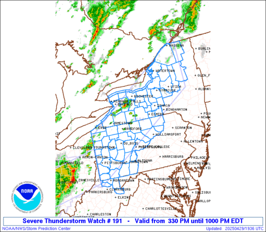
 URGENT - IMMEDIATE BROADCAST REQUESTED
Severe Thunderstorm Watch Number 191
NWS Storm Prediction Center Norman OK
330 PM EDT Tue Apr 29 2025 The NWS Storm Prediction Center has issued a * Severe Thunderstorm Watch for portions of Western and Northern New York Western and Central Pennsylvania Northern West Virginia Lake Erie Lake Ontario * Effective this Tuesday afternoon and evening from 330 PM until 1000 PM EDT. * Primary threats include... Scattered damaging wind gusts to 70 mph likely Scattered large hail events to 1.5 inches in diameter possible A tornado or two possible SUMMARY...Multiple lines and clusters of thunderstorms will traverse
the watch area through the afternoon and early evening. The
strongest storms will pose a risk of damaging winds gusts and some
hail. The severe thunderstorm watch area is approximately along and 80
statute miles north and south of a line from 15 miles west northwest
of Pittsburgh PA to 60 miles south southeast of Massena NY. For a
complete depiction of the watch see the associated watch outline
update (WOUS64 KWNS WOU1). PRECAUTIONARY/PREPAREDNESS ACTIONS... REMEMBER...A Severe Thunderstorm Watch means conditions are
favorable for severe thunderstorms in and close to the watch area.
Persons in these areas should be on the lookout for threatening
weather conditions and listen for later statements and possible
warnings. Severe thunderstorms can and occasionally do produce
tornadoes. && OTHER WATCH INFORMATION...CONTINUE...WW 187...WW 188...WW
189...WW 190... AVIATION...A few severe thunderstorms with hail surface and aloft to
1.5 inches. Extreme turbulence and surface wind gusts to 60 knots. A
few cumulonimbi with maximum tops to 500. Mean storm motion vector
24035. ...Hart
LIVE Now: Severe Thunderstorms and Tornadoes Across Texas | Breaking Weather Updates

LIVE Texas Severe Weather Coverage {Baldy-in-Chief David Reimer @texasstormchasers} for April 29, 2025. We will focus on the most intense storms to keep you informed, without the hype, and ahead of the storm. Remember, knowledge is power – and with that, you are already in better shape than those who may not know storms are […]
SPC Severe Thunderstorm Watch 190
WW 190 SEVERE TSTM OK TX 291900Z – 300200Z 
 URGENT - IMMEDIATE BROADCAST REQUESTED
Severe Thunderstorm Watch Number 190
NWS Storm Prediction Center Norman OK
200 PM CDT Tue Apr 29 2025 The NWS Storm Prediction Center has issued a * Severe Thunderstorm Watch for portions of Southwest Oklahoma West Central Texas * Effective this Tuesday afternoon and evening from 200 PM until 900 PM CDT. * Primary threats include... Scattered large hail and isolated very large hail events to 2.5 inches in diameter likely Scattered damaging wind gusts to 70 mph likely A tornado or two possible SUMMARY...Thunderstorms will increase in coverage and intensity
through the afternoon and early evening. Supercells capable of very
large hail are the main concern. The severe thunderstorm watch area is approximately along and 80
statute miles east and west of a line from 35 miles south southeast
of Midland TX to 40 miles east northeast of Clinton OK. For a
complete depiction of the watch see the associated watch outline
update (WOUS64 KWNS WOU0). PRECAUTIONARY/PREPAREDNESS ACTIONS... REMEMBER...A Severe Thunderstorm Watch means conditions are
favorable for severe thunderstorms in and close to the watch area.
Persons in these areas should be on the lookout for threatening
weather conditions and listen for later statements and possible
warnings. Severe thunderstorms can and occasionally do produce
tornadoes. && OTHER WATCH INFORMATION...CONTINUE...WW 187...WW 188...WW 189... AVIATION...A few severe thunderstorms with hail surface and aloft to
2.5 inches. Extreme turbulence and surface wind gusts to 60 knots. A
few cumulonimbi with maximum tops to 500. Mean storm motion vector
24035. ...Hart
SPC Severe Thunderstorm Watch 189
WW 189 SEVERE TSTM IL IN KY 291830Z – 300100Z 
 URGENT - IMMEDIATE BROADCAST REQUESTED
Severe Thunderstorm Watch Number 189
NWS Storm Prediction Center Norman OK
130 PM CDT Tue Apr 29 2025 The NWS Storm Prediction Center has issued a * Severe Thunderstorm Watch for portions of Southeast Illinois Southern Indiana Northwest Kentucky * Effective this Tuesday afternoon and evening from 130 PM until 800 PM CDT. * Primary threats include... Scattered damaging winds likely with isolated significant gusts to 75 mph possible Scattered large hail events to 1.5 inches in diameter possible A tornado or two possible SUMMARY...A cluster of thunderstorms over southeast Missouri will
track eastward through the afternoon, posing a risk of damaging wind
gusts and some hail. The severe thunderstorm watch area is approximately along and 55
statute miles north and south of a line from 5 miles north of
Carbondale IL to 35 miles north northeast of Louisville KY. For a
complete depiction of the watch see the associated watch outline
update (WOUS64 KWNS WOU9). PRECAUTIONARY/PREPAREDNESS ACTIONS... REMEMBER...A Severe Thunderstorm Watch means conditions are
favorable for severe thunderstorms in and close to the watch area.
Persons in these areas should be on the lookout for threatening
weather conditions and listen for later statements and possible
warnings. Severe thunderstorms can and occasionally do produce
tornadoes. && OTHER WATCH INFORMATION...CONTINUE...WW 187...WW 188... AVIATION...A few severe thunderstorms with hail surface and aloft to
1.5 inches. Extreme turbulence and surface wind gusts to 65 knots. A
few cumulonimbi with maximum tops to 500. Mean storm motion vector
25035. ...Hart
Watch: Barefoot Florida man wrangles alligator from side of busy interstate

Video captured on Sunday in Jacksonville shows a local alligator wrangler barefoot corralling a large gator from the median of Interstate 95.