Day: April 24, 2025
SPC Severe Thunderstorm Watch 166
WW 166 SEVERE TSTM TX 241955Z – 250100Z 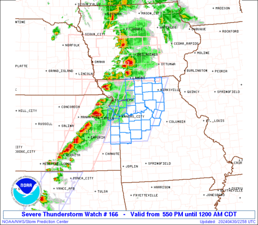
 URGENT - IMMEDIATE BROADCAST REQUESTED
Severe Thunderstorm Watch Number 166
NWS Storm Prediction Center Norman OK
255 PM CDT Thu Apr 24 2025 The NWS Storm Prediction Center has issued a * Severe Thunderstorm Watch for portions of Central into East Texas * Effective this Thursday afternoon and evening from 255 PM until 800 PM CDT. * Primary threats include... Scattered damaging wind gusts to 70 mph possible Isolated large hail events to 1.5 inches in diameter possible SUMMARY...A linear cluster of strong to severe thunderstorms will
likely continue east across much of the Watch area this afternoon
into the early evening. Severe gusts 60-70 mph appear to be the
primary hazard, but large hail may accompany the stronger cells on
the southwestern flank of the thunderstorm band. The severe thunderstorm watch area is approximately along and 50
statute miles north and south of a line from 35 miles west of Temple
TX to 25 miles east of Lufkin TX. For a complete depiction of the
watch see the associated watch outline update (WOUS64 KWNS WOU6). PRECAUTIONARY/PREPAREDNESS ACTIONS... REMEMBER...A Severe Thunderstorm Watch means conditions are
favorable for severe thunderstorms in and close to the watch area.
Persons in these areas should be on the lookout for threatening
weather conditions and listen for later statements and possible
warnings. Severe thunderstorms can and occasionally do produce
tornadoes. && AVIATION...A few severe thunderstorms with hail surface and aloft to
1.5 inches. Extreme turbulence and surface wind gusts to 60 knots. A
few cumulonimbi with maximum tops to 500. Mean storm motion vector
28030. ...Smith
How recently discovered giant magma ‘cap’ helps prevent eruption at Yellowstone National Park

Scientists found that a "cap" of bubbles and magma stands between the magma reservoir underneath Yellowstone National Park and a volcanic eruption.
Watch: Diving instructor spots large shark while swimming off South Carolina coast

Katherine Prandi posted a video of a large shark swimming by her while diving near Murrells Inlet.
Texas Braces for Severe Weather: Storm Timeline

Scattered thunderstorms reached Texoma and North Texas this morning, somewhat contradicting my forecast video posted yesterday morning. These storms have continued into the late morning, now extending from the eastern Big Country to southern areas of the D/FW Metroplex. It seems likely that storms will continue to develop further south this afternoon into southern North […]
Exclusive video reveals secretive Area 51 military base as seen from space

New 4K satellite imagery has been released that shows one of the most secretive locations in America â Area 51.
Watch: Flames from New Jersey wildfire inch dangerously close to homes

Firefighters in New Jersey are still working to extinguish the largest wildfire the Garden State has seen in years, and a dramatic new video shows just how close the flames and smoke came to homes in Ocean County.
Woman’s car left shattered after softball-sized hailstorm in Nebraska: ‘Don’t break my windshield, please!’

With severe weather season in full swing, thunderstorms continue to pound the Midwest with damaging winds and some substantial hail.
Daily Weather Update from FOX Weather: Threatening New Jersey wildfire smoke could choke NYC, Northeast

Top weather news for Thursday, April 24, 2025: The Jones Road Wildfire could be one of the largest wildfires that New Jersey has seen in years after it torched more than 10,000 acres in less than a day, officials said, warning that the flames could rage for days.
SPC – No watches are valid as of Thu Apr 24 10:02:02 UTC 2025
No watches are valid as of Thu Apr 24 10:02:02 UTC 2025.