Day: April 23, 2025
SPC Severe Thunderstorm Watch 165
WW 165 SEVERE TSTM OK TX 240420Z – 241000Z 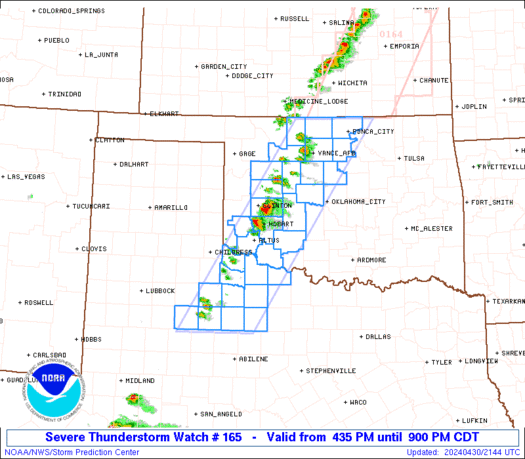
 URGENT - IMMEDIATE BROADCAST REQUESTED
Severe Thunderstorm Watch Number 165
NWS Storm Prediction Center Norman OK
1120 PM CDT Wed Apr 23 2025 The NWS Storm Prediction Center has issued a * Severe Thunderstorm Watch for portions of Southwest Oklahoma Western North Texas * Effective this Wednesday night and Thursday morning from 1120 PM until 500 AM CDT. * Primary threats include... Scattered damaging wind gusts to 70 mph possible Isolated large hail events to 1.5 inches in diameter possible SUMMARY...A cluster of storms should continue east-southeastward
into southwest Oklahoma and western North Texas early in the
overnight, with some continued potential for severe-caliber wind
gusts and sporadic hail. The severe thunderstorm watch area is approximately along and 70
statute miles north and south of a line from 50 miles southwest of
Altus OK to 45 miles south southeast of Altus OK. For a complete
depiction of the watch see the associated watch outline update
(WOUS64 KWNS WOU5). PRECAUTIONARY/PREPAREDNESS ACTIONS... REMEMBER...A Severe Thunderstorm Watch means conditions are
favorable for severe thunderstorms in and close to the watch area.
Persons in these areas should be on the lookout for threatening
weather conditions and listen for later statements and possible
warnings. Severe thunderstorms can and occasionally do produce
tornadoes. && OTHER WATCH INFORMATION...CONTINUE...WW 164... AVIATION...A few severe thunderstorms with hail surface and aloft to
1.5 inches. Extreme turbulence and surface wind gusts to 60 knots. A
few cumulonimbi with maximum tops to 500. Mean storm motion vector
27025. ...Guyer
Mapped: What a barrage of 56 West Coast atmospheric river events looks like

The past six months have proven to be a tale of two Californias when it comes to atmospheric river events. While Northern California experienced a surge in precipitation and significant impacts, Southern California remained largely dry, raising concerns about the upcoming fire season. The strongest atmospheric river struck in November, bringing widespread flooding, record-breaking rainfall, and hurricane-force winds to the northern part of the Golden State.
Bright green Comet SWAN falls apart after once-in-a-lifetime appearance in our night sky

Another comet has fascinated skygazers but has already sung its swan song after approaching the Sun.
SPC Severe Thunderstorm Watch 164
WW 164 SEVERE TSTM OK TX 232230Z – 240500Z 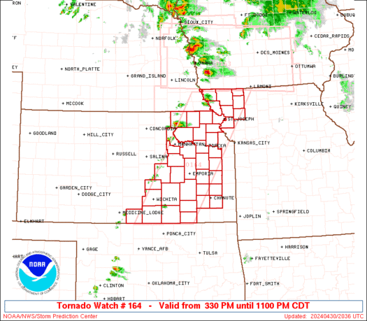
 URGENT - IMMEDIATE BROADCAST REQUESTED
Severe Thunderstorm Watch Number 164
NWS Storm Prediction Center Norman OK
530 PM CDT Wed Apr 23 2025 The NWS Storm Prediction Center has issued a * Severe Thunderstorm Watch for portions of Far Western Oklahoma Texas Panhandle and South Plains * Effective this Wednesday afternoon from 530 PM until Midnight CDT. * Primary threats include... Scattered large hail and isolated very large hail events to 2 inches in diameter possible Isolated damaging wind gusts to 70 mph possible A tornado or two possible SUMMARY...Relatively isolated severe storms should develop through
early/mid-evening, particularly across the Texas and Oklahoma
Panhandles, but potentially also across the Texas South Plains.
These storms may reach other parts of western Oklahoma later this
evening. The severe thunderstorm watch area is approximately along and 70
statute miles east and west of a line from 45 miles east northeast
of Guymon OK to 55 miles south southeast of Lubbock TX. For a
complete depiction of the watch see the associated watch outline
update (WOUS64 KWNS WOU4). PRECAUTIONARY/PREPAREDNESS ACTIONS... REMEMBER...A Severe Thunderstorm Watch means conditions are
favorable for severe thunderstorms in and close to the watch area.
Persons in these areas should be on the lookout for threatening
weather conditions and listen for later statements and possible
warnings. Severe thunderstorms can and occasionally do produce
tornadoes. && OTHER WATCH INFORMATION...CONTINUE...WW 162...WW 163... AVIATION...A few severe thunderstorms with hail surface and aloft to
2 inches. Extreme turbulence and surface wind gusts to 60 knots. A
few cumulonimbi with maximum tops to 500. Mean storm motion vector
24020. ...Guyer
NOAA mission finds unexpected discovery at site of sunken USS Yorktown

During a 28-day deep-sea expedition of the PapahÄnaumokuÄkea region, a camera aboard a remotely operated vehicle spotted a vintage automobile resting inside the wreckage USS Yorktown. The wreckage of the Yorktown was first documented in 1998, but there were no indications of any automobiles being on board. According to the U.S. Navy the ship sank after being hit by Japanese torpedoes during the Battle of Midway on June 7, 1942.
SPC Severe Thunderstorm Watch 163
WW 163 SEVERE TSTM CO KS 232050Z – 240400Z 
 URGENT - IMMEDIATE BROADCAST REQUESTED
Severe Thunderstorm Watch Number 163
NWS Storm Prediction Center Norman OK
350 PM CDT Wed Apr 23 2025 The NWS Storm Prediction Center has issued a * Severe Thunderstorm Watch for portions of Eastern Colorado Western Kansas * Effective this Wednesday afternoon and evening from 350 PM until 1100 PM CDT. * Primary threats include... Scattered large hail likely with isolated very large hail events to 2.5 inches in diameter possible Scattered damaging wind gusts to 70 mph possible A tornado or two possible SUMMARY...Thunderstorms will increase in coverage through the late
afternoon and evening across the watch area, with a few supercells
possible. Large hail is the primary concern, however a tornado or
two could occur later this evening as well. The severe thunderstorm watch area is approximately along and 70
statute miles east and west of a line from 55 miles northeast of
Goodland KS to 5 miles east of Elkhart KS. For a complete depiction
of the watch see the associated watch outline update (WOUS64 KWNS
WOU3). PRECAUTIONARY/PREPAREDNESS ACTIONS... REMEMBER...A Severe Thunderstorm Watch means conditions are
favorable for severe thunderstorms in and close to the watch area.
Persons in these areas should be on the lookout for threatening
weather conditions and listen for later statements and possible
warnings. Severe thunderstorms can and occasionally do produce
tornadoes. && OTHER WATCH INFORMATION...CONTINUE...WW 162... AVIATION...A few severe thunderstorms with hail surface and aloft to
2.5 inches. Extreme turbulence and surface wind gusts to 60 knots. A
few cumulonimbi with maximum tops to 500. Mean storm motion vector
26030. ...Hart
