Day: April 19, 2025
SPC Tornado Watch 152
WW 152 TORNADO AR OK TX 200430Z – 201200Z 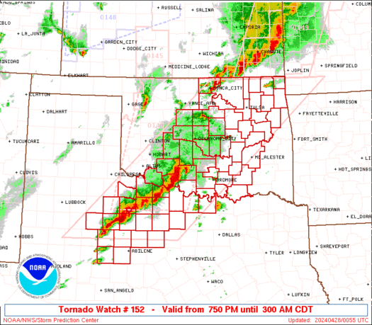
 URGENT - IMMEDIATE BROADCAST REQUESTED
Tornado Watch Number 152
NWS Storm Prediction Center Norman OK
1130 PM CDT Sat Apr 19 2025 The NWS Storm Prediction Center has issued a * Tornado Watch for portions of West-Central and Northwest Arkansas Eastern and Southeast Oklahoma Central and North Texas * Effective this Saturday night and Sunday morning from 1130 PM until 700 AM CDT. * Primary threats include... A few tornadoes and a couple intense tornadoes possible Scattered damaging wind gusts to 70 mph likely Scattered large hail events to 1.5 inches in diameter possible SUMMARY...A broken band of strong to severe thunderstorms will
continue to progress east-northeast across the Watch area tonight. The severe risk, including the potential for a few tornadoes, will
likely focus with supercells and bowing line segments. A strong
tornado or two remains possible due to a moist and strongly sheared
environment expected to persist through tonight. The tornado watch area is approximately along and 60 statute miles
east and west of a line from 35 miles west northwest of Harrison AR
to 25 miles east southeast of Brownwood TX. For a complete depiction
of the watch see the associated watch outline update (WOUS64 KWNS
WOU2). PRECAUTIONARY/PREPAREDNESS ACTIONS... REMEMBER...A Tornado Watch means conditions are favorable for
tornadoes and severe thunderstorms in and close to the watch
area. Persons in these areas should be on the lookout for
threatening weather conditions and listen for later statements
and possible warnings. && OTHER WATCH INFORMATION...CONTINUE...WW 149...WW 150...WW 151... AVIATION...Tornadoes and a few severe thunderstorms with hail
surface and aloft to 1.5 inches. Extreme turbulence and surface wind
gusts to 60 knots. A few cumulonimbi with maximum tops to 500. Mean
storm motion vector 24035. ...Smith
SPC Tornado Watch 151
WW 151 TORNADO TX 200300Z – 201000Z 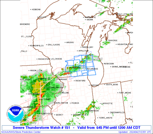
 URGENT - IMMEDIATE BROADCAST REQUESTED
Tornado Watch Number 151
NWS Storm Prediction Center Norman OK
1000 PM CDT Sat Apr 19 2025 The NWS Storm Prediction Center has issued a * Tornado Watch for portions of Southwest into Central Texas * Effective this Saturday night and Sunday morning from 1000 PM until 500 AM CDT. * Primary threats include... A couple tornadoes possible Scattered large hail and isolated very large hail events to 2 inches in diameter possible Scattered damaging wind gusts to 70 mph possible SUMMARY...A band of thunderstorms is forecast to intensify and move
from west to east across the Watch area tonight. The warm sector
environment will support the possibility for a couple of tornadoes,
in addition to large hail and severe gusts with the stronger storms. The tornado watch area is approximately along and 60 statute miles
north and south of a line from 95 miles southwest of San Angelo TX
to 80 miles east northeast of Junction TX. For a complete depiction
of the watch see the associated watch outline update (WOUS64 KWNS
WOU1). PRECAUTIONARY/PREPAREDNESS ACTIONS... REMEMBER...A Tornado Watch means conditions are favorable for
tornadoes and severe thunderstorms in and close to the watch
area. Persons in these areas should be on the lookout for
threatening weather conditions and listen for later statements
and possible warnings. && OTHER WATCH INFORMATION...CONTINUE...WW 147...WW 148...WW
149...WW 150... AVIATION...Tornadoes and a few severe thunderstorms with hail
surface and aloft to 2 inches. Extreme turbulence and surface wind
gusts to 60 knots. A few cumulonimbi with maximum tops to 500. Mean
storm motion vector 26035. ...Smith
SPC Severe Thunderstorm Watch 150
WW 150 SEVERE TSTM TX 200250Z – 201000Z 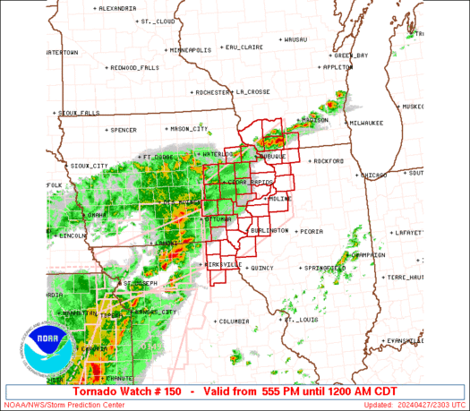
 URGENT - IMMEDIATE BROADCAST REQUESTED
Severe Thunderstorm Watch Number 150
NWS Storm Prediction Center Norman OK
950 PM CDT Sat Apr 19 2025 The NWS Storm Prediction Center has issued a * Severe Thunderstorm Watch for portions of West into Northwest Texas * Effective this Saturday night and Sunday morning from 950 PM until 500 AM CDT. * Primary threats include... Scattered damaging wind gusts to 70 mph likely Scattered large hail and isolated very large hail events to 2 inches in diameter possible SUMMARY...A intensifying band of thunderstorms is forecast to move
from west to east across the Watch area tonight. Large hail and
severe gusts are possible with the more intense thunderstorms. The severe thunderstorm watch area is approximately along and 75
statute miles north and south of a line from 80 miles northeast of
Abilene TX to 15 miles northwest of Midland TX. For a complete
depiction of the watch see the associated watch outline update
(WOUS64 KWNS WOU0). PRECAUTIONARY/PREPAREDNESS ACTIONS... REMEMBER...A Severe Thunderstorm Watch means conditions are
favorable for severe thunderstorms in and close to the watch area.
Persons in these areas should be on the lookout for threatening
weather conditions and listen for later statements and possible
warnings. Severe thunderstorms can and occasionally do produce
tornadoes. && OTHER WATCH INFORMATION...CONTINUE...WW 147...WW 148...WW 149... AVIATION...A few severe thunderstorms with hail surface and aloft to
2 inches. Extreme turbulence and surface wind gusts to 60 knots. A
few cumulonimbi with maximum tops to 500. Mean storm motion vector
26035. ...Smith
SPC Tornado Watch 149
WW 149 TORNADO OK TX 192345Z – 200500Z 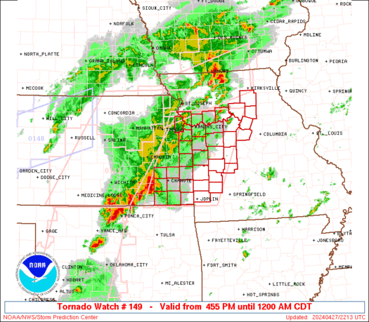
 URGENT - IMMEDIATE BROADCAST REQUESTED
Tornado Watch Number 149
NWS Storm Prediction Center Norman OK
645 PM CDT Sat Apr 19 2025 The NWS Storm Prediction Center has issued a * Tornado Watch for portions of Southern and Southeast Oklahoma North Texas * Effective this Saturday night from 645 PM until Midnight CDT. * Primary threats include... A couple tornadoes possible Scattered large hail and isolated very large hail events to 2.5 inches in diameter possible Scattered damaging wind gusts to 70 mph possible SUMMARY...Scattered to numerous thunderstorms are forecast to
develop and intensify over the Watch area this evening. A few
supercells are likely to develop as the low-level jet strengthens
this evening, while conditions remains moist and adequately unstable
for surface-based storms. A couple of tornadoes are possible with
the stronger storms, in addition to the risk for large hail and
severe gusts. The tornado watch area is approximately along and 50 statute miles
east and west of a line from 15 miles northwest of Mcalester OK to
10 miles southeast of Mineral Wells TX. For a complete depiction of
the watch see the associated watch outline update (WOUS64 KWNS
WOU9). PRECAUTIONARY/PREPAREDNESS ACTIONS... REMEMBER...A Tornado Watch means conditions are favorable for
tornadoes and severe thunderstorms in and close to the watch
area. Persons in these areas should be on the lookout for
threatening weather conditions and listen for later statements
and possible warnings. && OTHER WATCH INFORMATION...CONTINUE...WW 147...WW 148... AVIATION...Tornadoes and a few severe thunderstorms with hail
surface and aloft to 2.5 inches. Extreme turbulence and surface wind
gusts to 60 knots. A few cumulonimbi with maximum tops to 500. Mean
storm motion vector 21030. ...Smith
Boston Marathon to somehow escape heat, rain during 129th race

Temperatures are expected to start out in the 40s for the marathonâs military march at 6 a.m. A group of professional men and women is slated to start between 9 a.m. and 10 a.m., with all participating categories underway by around 11:15 a.m. on Monday, April 21, 2025. Monday also marks Patriots' Day, which commemorates the start of the American Revolution.
April 19, 2025 Texas Severe Weather Coverage

LIVE Texas Severe Weather Coverage {Baldy-in-Chief David Reimer @texasstormchasers} for April 19, 2025. We will focus on the most intense storms to keep you informed, without the hype, and ahead of the storm. Remember, knowledge is power – and with that, you are already in better shape than those who may not know storms are […]