Easter weekend storms: What you need to know
Weather updates for Easter weekend. Learn about the storm chances and severe weather threats from KSAT 12’s meteorologist.
24/7 Tornado Newsfeed
Weather updates for Easter weekend. Learn about the storm chances and severe weather threats from KSAT 12’s meteorologist.
WW 141 TORNADO IA NE 172145Z – 180500Z 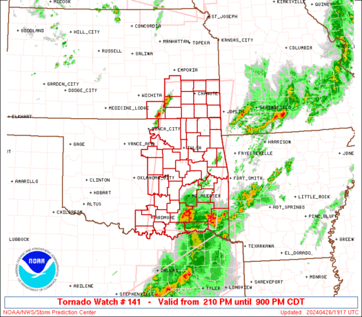
 URGENT - IMMEDIATE BROADCAST REQUESTED
Tornado Watch Number 141
NWS Storm Prediction Center Norman OK
445 PM CDT Thu Apr 17 2025 The NWS Storm Prediction Center has issued a * Tornado Watch for portions of Western Iowa Eastern Nebraska * Effective this Thursday afternoon from 445 PM until Midnight CDT. * Primary threats include... A couple tornadoes possible Scattered large hail likely with isolated very large hail events to 3 inches in diameter possible Scattered damaging wind gusts to 70 mph possible SUMMARY...Severe storms are expected to increase from west to east
near a boundary that extends across the region. Large hail will be
the most common risk, but damaging winds are also expected, and a
risk for tornadoes will increase through early evening. The tornado watch area is approximately along and 60 statute miles
north and south of a line from 55 miles southeast of Denison IA to
60 miles southwest of Columbus NE. For a complete depiction of the
watch see the associated watch outline update (WOUS64 KWNS WOU1). PRECAUTIONARY/PREPAREDNESS ACTIONS... REMEMBER...A Tornado Watch means conditions are favorable for
tornadoes and severe thunderstorms in and close to the watch
area. Persons in these areas should be on the lookout for
threatening weather conditions and listen for later statements
and possible warnings. && OTHER WATCH INFORMATION...CONTINUE...WW 140... AVIATION...Tornadoes and a few severe thunderstorms with hail
surface and aloft to 3 inches. Extreme turbulence and surface wind
gusts to 60 knots. A few cumulonimbi with maximum tops to 550. Mean
storm motion vector 24025. ...Guyer

The arrival of warm spring temperatures also means the arrival of cicadas, which are expected to start filling the air with their iconic buzzing sounds as soon as next week in some parts of the U.S.
WW 140 SEVERE TSTM IA MN NE WI 172045Z – 180300Z 
 URGENT - IMMEDIATE BROADCAST REQUESTED
Severe Thunderstorm Watch Number 140
NWS Storm Prediction Center Norman OK
345 PM CDT Thu Apr 17 2025 The NWS Storm Prediction Center has issued a * Severe Thunderstorm Watch for portions of Northwest and Northern Iowa Southern and Southeast Minnesota Far Northeast Nebraska West-Central Wisconsin * Effective this Thursday afternoon and evening from 345 PM until 1000 PM CDT. * Primary threats include... Scattered large hail and isolated very large hail events to 2 inches in diameter possible Scattered damaging wind gusts to 70 mph possible SUMMARY...Scattered thunderstorms are forecast to develop and
intensify through the early evening across the Watch area. The
stronger storms will be capable of a threat for large to very large
hail (1 to 2 inches in diameter) and damaging gusts. Upscale growth
into a linear cluster is possible this evening across southern
Minnesota as this activity moves east towards the Mississippi River. The severe thunderstorm watch area is approximately along and 65
statute miles east and west of a line from 25 miles northeast of
Minneapolis MN to 30 miles south southwest of Storm Lake IA. For a
complete depiction of the watch see the associated watch outline
update (WOUS64 KWNS WOU0). PRECAUTIONARY/PREPAREDNESS ACTIONS... REMEMBER...A Severe Thunderstorm Watch means conditions are
favorable for severe thunderstorms in and close to the watch area.
Persons in these areas should be on the lookout for threatening
weather conditions and listen for later statements and possible
warnings. Severe thunderstorms can and occasionally do produce
tornadoes. && AVIATION...A few severe thunderstorms with hail surface and aloft to
2 inches. Extreme turbulence and surface wind gusts to 60 knots. A
few cumulonimbi with maximum tops to 450. Mean storm motion vector
25030. ...Smith

Scientists provided an update Thursday on the chances of an eruption of the Mount Spurr volcano in Alaska, a situation being closely monitored by officials in Anchorage, the state's largest city.

What began as a typical training day Sunday for climbers practicing a rescue course along Peru's Vallunaraju Mountain turned into a terrifying scene when a giant glacier suddenly broke apart right behind them.

Turns out, the real catch of the day wasn't waiting for bride Miccala Toms at the altar but lurking beneath the waves with a toothy grin.

A family of some of the littlest foxes in North America was caught on camera running through the California desert.