SPC – No watches are valid as of Tue Apr 15 03:13:02 UTC 2025
No watches are valid as of Tue Apr 15 03:13:02 UTC 2025.
24/7 Tornado Newsfeed
No watches are valid as of Tue Apr 15 03:13:02 UTC 2025.
WW 139 SEVERE TSTM VA WV 142250Z – 150500Z 
 URGENT - IMMEDIATE BROADCAST REQUESTED
Severe Thunderstorm Watch Number 139
NWS Storm Prediction Center Norman OK
650 PM EDT Mon Apr 14 2025 The NWS Storm Prediction Center has issued a * Severe Thunderstorm Watch for portions of Northern and Central Virginia Eastern West Virginia * Effective this Monday night and Tuesday morning from 650 PM until 100 AM EDT. * Primary threats include... Scattered damaging wind gusts to 70 mph likely Scattered large hail and isolated very large hail events to 2 inches in diameter possible SUMMARY...Supercells will continue to move eastward this evening
while posing a threat for large to very large hail up to 1-2 inches
in diameter. Scattered damaging winds with peak gusts of 60-70 mph
will also be likely with any clusters that can form while also
spreading quickly eastward. The severe thunderstorm watch area is approximately along and 55
statute miles north and south of a line from 35 miles northwest of
Staunton VA to 35 miles north of Richmond VA. For a complete
depiction of the watch see the associated watch outline update
(WOUS64 KWNS WOU9). PRECAUTIONARY/PREPAREDNESS ACTIONS... REMEMBER...A Severe Thunderstorm Watch means conditions are
favorable for severe thunderstorms in and close to the watch area.
Persons in these areas should be on the lookout for threatening
weather conditions and listen for later statements and possible
warnings. Severe thunderstorms can and occasionally do produce
tornadoes. && OTHER WATCH INFORMATION...CONTINUE...WW 138... AVIATION...A few severe thunderstorms with hail surface and aloft to
2 inches. Extreme turbulence and surface wind gusts to 60 knots. A
few cumulonimbi with maximum tops to 500. Mean storm motion vector
28045. ...Gleason

An astonishing discovery has been unearthed by paleontologists in Argentina.

A newly discovered comet is fascinating astronomers and amateur stargazers alike as it remains a brightening feature in the northeast night sky.
WW 138 SEVERE TSTM KY OH PA VA WV 141925Z – 150300Z 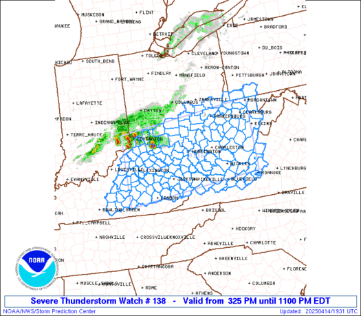
 URGENT - IMMEDIATE BROADCAST REQUESTED
Severe Thunderstorm Watch Number 138
NWS Storm Prediction Center Norman OK
325 PM EDT Mon Apr 14 2025 The NWS Storm Prediction Center has issued a * Severe Thunderstorm Watch for portions of Central and Eastern Kentucky Southern Ohio Far Southwestern Pennsylvania Southwestern Virginia West Virginia * Effective this Monday afternoon and evening from 325 PM until 1100 PM EDT. * Primary threats include... Scattered damaging wind gusts to 70 mph likely Scattered large hail and isolated very large hail events to 2 inches in diameter possible A tornado or two possible SUMMARY...Thunderstorms coverage is expected to increase over the
next few hours along and ahead of a cold front pushing eastward
across the region. Environmental conditions support strong to severe
storms. An initially cellular mode will favor large hail and
damaging gusts before a transition to a more linear storm mode
favors primarily damaging gusts. The severe thunderstorm watch area is approximately along and 80
statute miles north and south of a line from 30 miles west of
Lexington KY to 60 miles north northeast of White Sulphur Springs
WV. For a complete depiction of the watch see the associated watch
outline update (WOUS64 KWNS WOU8). PRECAUTIONARY/PREPAREDNESS ACTIONS... REMEMBER...A Severe Thunderstorm Watch means conditions are
favorable for severe thunderstorms in and close to the watch area.
Persons in these areas should be on the lookout for threatening
weather conditions and listen for later statements and possible
warnings. Severe thunderstorms can and occasionally do produce
tornadoes. && AVIATION...A few severe thunderstorms with hail surface and aloft to
2 inches. Extreme turbulence and surface wind gusts to 60 knots. A
few cumulonimbi with maximum tops to 500. Mean storm motion vector
24040. ...Mosier

Cameras across Southern California captured a startling scene on Monday that shook residents and their pets as a magnitude 5.2 earthquake struck east of San Diego.

Residents in Southern California were rattled by an earthquake on Monday.

A Florida man stepped outside his home last week and was met with a strange sight — a massive dust devil.