WW 106 SEVERE TSTM TX 030625Z – 031300Z
URGENT - IMMEDIATE BROADCAST REQUESTED
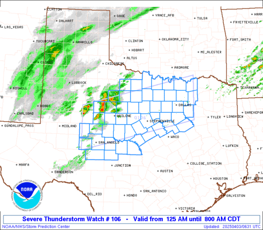
Severe Thunderstorm Watch Number 106
NWS Storm Prediction Center Norman OK
125 AM CDT Thu Apr 3 2025 The NWS Storm Prediction Center has issued a * Severe Thunderstorm Watch for portions of Western into North-Central Texas * Effective this Thursday morning from 125 AM until 800 AM CDT. * Primary threats include... Scattered large hail and isolated very large hail events to 2.5 inches in diameter likely Isolated damaging wind gusts to 60 mph possible SUMMARY...Elevated supercells should pose a threat for mainly large
to very large hail this morning as they move quickly northeastward.
Some of the hail could reach up to 2-2.5 inches in diameter. The severe thunderstorm watch area is approximately along and 60
statute miles north and south of a line from 55 miles northwest of
San Angelo TX to 50 miles east northeast of Dallas TX. For a
complete depiction of the watch see the associated watch outline
update (WOUS64 KWNS WOU6). PRECAUTIONARY/PREPAREDNESS ACTIONS... REMEMBER...A Severe Thunderstorm Watch means conditions are
favorable for severe thunderstorms in and close to the watch area.
Persons in these areas should be on the lookout for threatening
weather conditions and listen for later statements and possible
warnings. Severe thunderstorms can and occasionally do produce
tornadoes. && OTHER WATCH INFORMATION...CONTINUE...WW 103...WW 104...WW 105... AVIATION...A few severe thunderstorms with hail surface and aloft to
2.5 inches. Extreme turbulence and surface wind gusts to 50 knots. A
few cumulonimbi with maximum tops to 500. Mean storm motion vector
23040. ...Gleason
Read more

