Day: April 2, 2025
SPC PDS Tornado Watch 98
WW 98 TORNADO AR IL IN KY MO MS TN 021950Z – 030500Z 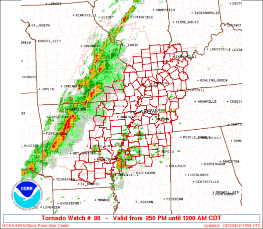
 URGENT - IMMEDIATE BROADCAST REQUESTED
Tornado Watch Number 98
NWS Storm Prediction Center Norman OK
250 PM CDT Wed Apr 2 2025 The NWS Storm Prediction Center has issued a * Tornado Watch for portions of Eastern and South-Central Arkansas Southern Illinois Southwest Indiana Western Kentucky Southeast Missouri Northern Mississippi Western Tennessee * Effective this Wednesday afternoon from 250 PM until Midnight CDT. ...THIS IS A PARTICULARLY DANGEROUS SITUATION... * Primary threats include... Several tornadoes and a few intense tornadoes likely Widespread damaging winds and isolated significant gusts to 80 mph likely Scattered large hail and isolated very large hail events to 2 inches in diameter possible SUMMARY...Storms are expected to develop this afternoon initially
across the ArkLaMiss and Mid-South, with the overall environment
becoming increasingly favorable for tornadoes through late afternoon
into early/mid-evening. Some of these tornadoes may be strong or
intense (EF3+), with widespread damaging winds also likely across
the region by evening. This is a Particularly Dangerous Situation
with intense storms expected over a relatively broad regional area,
with multiple rounds of severe storms possible in some areas. The tornado watch area is approximately along and 90 statute miles
east and west of a line from 55 miles southeast of Pine Bluff AR to
30 miles northwest of Evansville IN. For a complete depiction of the
watch see the associated watch outline update (WOUS64 KWNS WOU8). PRECAUTIONARY/PREPAREDNESS ACTIONS... REMEMBER...A Tornado Watch means conditions are favorable for
tornadoes and severe thunderstorms in and close to the watch
area. Persons in these areas should be on the lookout for
threatening weather conditions and listen for later statements
and possible warnings. && OTHER WATCH INFORMATION...CONTINUE...WW 97... AVIATION...Tornadoes and a few severe thunderstorms with hail
surface and aloft to 2 inches. Extreme turbulence and surface wind
gusts to 70 knots. A few cumulonimbi with maximum tops to 550. Mean
storm motion vector 24035. ...Guyer
Beryl, Helene, Milton retired from Atlantic hurricane naming list after their historic impacts

About 100 names of tropical storms and hurricanes have been retired from future use in the Atlantic Ocean, and now Beryl, Helene and Milton join them.
TEXAS: Two Rounds of Severe Storms Possible Today & Tonight

Two rounds of potentially severe storms could impact the Big Country, North Texas, Texoma, Northeast Texas, and the Ark-La-Tex this afternoon and again after midnight into Thursday morning. This afternoon’s storms may intensify in Northeast Texas and eastern North Texas. Some data suggests that these storms could produce large hail and localized damaging wind […]
See it: Suspected Oklahoma tornado tears roofs off buildings as severe weather threat marches across US

A likely tornado barreled through the northeastern Oklahoma town of Owasso on Wednesday morning, leaving behind a trail of destruction.
SPC Tornado Watch 97
WW 97 TORNADO AR IL MO 021345Z – 022100Z 
 URGENT - IMMEDIATE BROADCAST REQUESTED
Tornado Watch Number 97
NWS Storm Prediction Center Norman OK
845 AM CDT Wed Apr 2 2025 The NWS Storm Prediction Center has issued a * Tornado Watch for portions of Northern and Central Arkansas Southern Illinois Southern and Eastern Missouri * Effective this Wednesday morning and afternoon from 845 AM until 400 PM CDT. * Primary threats include... A few tornadoes likely with a couple intense tornadoes possible Scattered damaging wind gusts to 70 mph likely Scattered large hail events to 1.5 inches in diameter possible SUMMARY...Broken clusters of storms and some embedded/semi-discrete
supercells will spread east-northeastward across the region through
early/mid-afternoon, with an increasing tornado risk aside from
widespread damaging winds and hail. The tornado watch area is approximately along and 60 statute miles
east and west of a line from 50 miles north northwest of Alton IL to
30 miles west southwest of Hot Springs AR. For a complete depiction
of the watch see the associated watch outline update (WOUS64 KWNS
WOU7). PRECAUTIONARY/PREPAREDNESS ACTIONS... REMEMBER...A Tornado Watch means conditions are favorable for
tornadoes and severe thunderstorms in and close to the watch
area. Persons in these areas should be on the lookout for
threatening weather conditions and listen for later statements
and possible warnings. && OTHER WATCH INFORMATION...CONTINUE...WW 94...WW 95...WW 96... AVIATION...Tornadoes and a few severe thunderstorms with hail
surface and aloft to 1.5 inches. Extreme turbulence and surface wind
gusts to 60 knots. A few cumulonimbi with maximum tops to 500. Mean
storm motion vector 25040. ...Guyer
Historic flash flooding worries grow in mid-South with over a foot of rain possible through weekend

With the potential for once-in-a-lifetime rainfall and widespread impacts, historic flash flooding is increasingly likely across parts of the nation through Saturday, fueled by repeated rounds of storms accompanying a rare high-level severe weather threat, forecasters warn.
Life-threatening tornado outbreak expected Wednesday amid rare high-risk severe weather threat

A tornado outbreak is expected Wednesday and Wednesday night from parts of the mid-Mississippi and lower Ohio valleys westward into the eastern Ozarks, including the threat of multiple long-track EF-3 or stronger tornadoes.
Daily Weather Update from FOX Weather: Expected tornado outbreak prompts rare ‘high risk’ of severe weather

Top weather news for April 2, 2025: A tornado outbreak is expected Wednesday and Wednesday night from parts of the mid-Mississippi and lower Ohio valleys westward into the eastern Ozarks, prompting a rare Level 5 out of 5 "high risk" of severe weather.