Month: March 2025
SPC Severe Thunderstorm Watch 25
WW 25 SEVERE TSTM FL GA SC CW 050815Z – 051500Z 
 URGENT - IMMEDIATE BROADCAST REQUESTED
Severe Thunderstorm Watch Number 25
NWS Storm Prediction Center Norman OK
315 AM EST Wed Mar 5 2025 The NWS Storm Prediction Center has issued a * Severe Thunderstorm Watch for portions of North Florida Southern into Southeast Georgia Southern South Carolina Coastal Waters * Effective this Wednesday morning from 315 AM until 1000 AM EST. * Primary threats include... Scattered damaging wind gusts to 70 mph possible A tornado or two possible SUMMARY...A squall line will move eastward across the Watch area
overnight into the morning. Damaging gusts ranging 55-70 mph are
possible with the stronger inflections and bowing segments within
the convective line. A brief tornado is also possible. The severe thunderstorm watch area is approximately along and 90
statute miles east and west of a line from 55 miles north northeast
of Vidalia GA to 55 miles south of Valdosta GA. For a complete
depiction of the watch see the associated watch outline update
(WOUS64 KWNS WOU5). PRECAUTIONARY/PREPAREDNESS ACTIONS... REMEMBER...A Severe Thunderstorm Watch means conditions are
favorable for severe thunderstorms in and close to the watch area.
Persons in these areas should be on the lookout for threatening
weather conditions and listen for later statements and possible
warnings. Severe thunderstorms can and occasionally do produce
tornadoes. && OTHER WATCH INFORMATION...CONTINUE...WW 23...WW 24... AVIATION...A few severe thunderstorms with hail surface and aloft to
0.5 inches. Extreme turbulence and surface wind gusts to 60 knots. A
few cumulonimbi with maximum tops to 350. Mean storm motion vector
26035. ...Smith
SPC Tornado Watch 24
WW 24 TORNADO AL FL GA CW 050450Z – 051200Z 
 URGENT - IMMEDIATE BROADCAST REQUESTED
Tornado Watch Number 24
NWS Storm Prediction Center Norman OK
1050 PM CST Tue Mar 4 2025 The NWS Storm Prediction Center has issued a * Tornado Watch for portions of Southeast Alabama Florida Panhandle Southwest Georgia Coastal Waters * Effective this Tuesday night and Wednesday morning from 1050 PM until 600 AM CST. * Primary threats include... A couple tornadoes possible Scattered damaging wind gusts to 70 mph likely SUMMARY...A band of storms will continue to progress eastward across
the region through late evening and overnight, with tornado and
damaging wind risks. The tornado watch area is approximately along and 75 statute miles
north and south of a line from 45 miles northwest of Panama City FL
to 20 miles north northeast of Tallahassee FL. For a complete
depiction of the watch see the associated watch outline update
(WOUS64 KWNS WOU4). PRECAUTIONARY/PREPAREDNESS ACTIONS... REMEMBER...A Tornado Watch means conditions are favorable for
tornadoes and severe thunderstorms in and close to the watch
area. Persons in these areas should be on the lookout for
threatening weather conditions and listen for later statements
and possible warnings. && OTHER WATCH INFORMATION...CONTINUE...WW 22...WW 23... AVIATION...Tornadoes and a few severe thunderstorms with hail
surface and aloft to 0.5 inches. Extreme turbulence and surface wind
gusts to 60 knots. A few cumulonimbi with maximum tops to 450. Mean
storm motion vector 25030. ...Guyer
SPC Severe Thunderstorm Watch 23
WW 23 SEVERE TSTM AL GA 050325Z – 050900Z 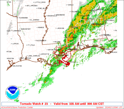
 URGENT - IMMEDIATE BROADCAST REQUESTED
Severe Thunderstorm Watch Number 23
NWS Storm Prediction Center Norman OK
925 PM CST Tue Mar 4 2025 The NWS Storm Prediction Center has issued a * Severe Thunderstorm Watch for portions of Eastern Alabama Western Georgia * Effective this Tuesday night and Wednesday morning from 925 PM until 300 AM CST. * Primary threats include... Scattered damaging wind gusts to 70 mph likely A tornado or two possible SUMMARY...A line of storms will continue to pose a risk for wind
damage, and possibly a brief tornado risk, from eastern Alabama into
western Georgia. The severe thunderstorm watch area is approximately along and 45
statute miles east and west of a line from 50 miles northwest of
Rome GA to 20 miles east southeast of Troy AL. For a complete
depiction of the watch see the associated watch outline update
(WOUS64 KWNS WOU3). PRECAUTIONARY/PREPAREDNESS ACTIONS... REMEMBER...A Severe Thunderstorm Watch means conditions are
favorable for severe thunderstorms in and close to the watch area.
Persons in these areas should be on the lookout for threatening
weather conditions and listen for later statements and possible
warnings. Severe thunderstorms can and occasionally do produce
tornadoes. && OTHER WATCH INFORMATION...CONTINUE...WW 22... AVIATION...A few severe thunderstorms with hail surface and aloft to
0.5 inches. Extreme turbulence and surface wind gusts to 60 knots. A
few cumulonimbi with maximum tops to 450. Mean storm motion vector
24040. ...Guyer
Tornado leaves path of destruction in Oklahoma amid widespread severe weather outbreak

A tornado punctuated a severe thunderstorm that blew through Ada, Oklahoma early Tuesday morning.
Tornado strikes Dallas suburb as severe weather outbreak sweeps South

An EF-1 tornado struck the Dallas suburb of Irving, Texas, on Tuesday morning as a line of severe weather swept through the Deep South.
SPC Tornado Watch 22
WW 22 TORNADO AL FL CW 042340Z – 050700Z 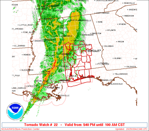
 URGENT - IMMEDIATE BROADCAST REQUESTED
Tornado Watch Number 22
NWS Storm Prediction Center Norman OK
540 PM CST Tue Mar 4 2025 The NWS Storm Prediction Center has issued a * Tornado Watch for portions of Southern and South-Central Alabama Western Florida Panhandle Coastal Waters * Effective this Tuesday afternoon and Wednesday morning from 540 PM until 100 AM CST. * Primary threats include... A few tornadoes likely with a couple intense tornadoes possible Scattered damaging winds likely with isolated significant gusts to 80 mph possible Isolated large hail events to 1 inch in diameter possible SUMMARY...Severe storm potential including the risk for tornadoes
will increase through early/mid-evening especially across southwest
Alabama, and eventually parts of the western Florida Panhandle and
south-central Alabama. The tornado watch area is approximately along and 95 statute miles
north and south of a line from 60 miles north of Mobile AL to 45
miles north northeast of Crestview FL. For a complete depiction of
the watch see the associated watch outline update (WOUS64 KWNS
WOU2). PRECAUTIONARY/PREPAREDNESS ACTIONS... REMEMBER...A Tornado Watch means conditions are favorable for
tornadoes and severe thunderstorms in and close to the watch
area. Persons in these areas should be on the lookout for
threatening weather conditions and listen for later statements
and possible warnings. && OTHER WATCH INFORMATION...CONTINUE...WW 21... AVIATION...Tornadoes and a few severe thunderstorms with hail
surface and aloft to 1 inch. Extreme turbulence and surface wind
gusts to 70 knots. A few cumulonimbi with maximum tops to 500. Mean
storm motion vector 23035. ...Guyer