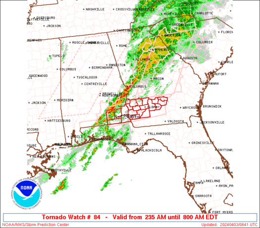
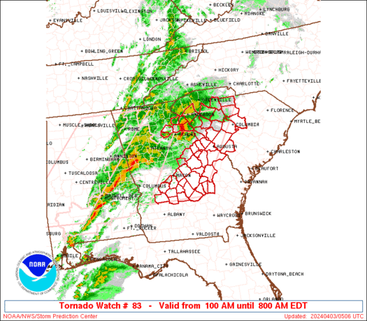
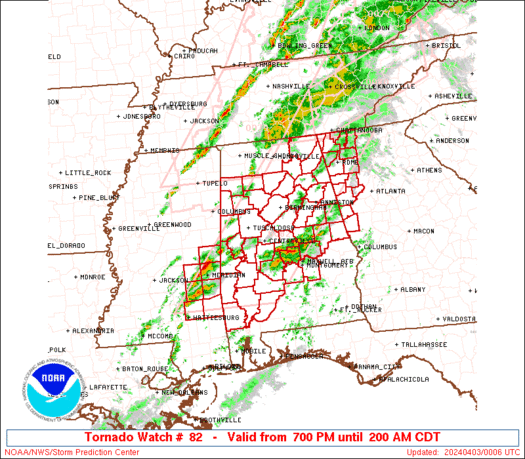
SPC Severe Thunderstorm Watch 85

WW 85 SEVERE TSTM AL GA MS 310945Z – 311700Z
WW 0085 Image

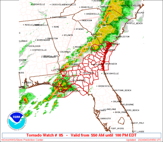
 URGENT - IMMEDIATE BROADCAST REQUESTED
Severe Thunderstorm Watch Number 85
NWS Storm Prediction Center Norman OK
445 AM CDT Mon Mar 31 2025 The NWS Storm Prediction Center has issued a * Severe Thunderstorm Watch for portions of Northern and Central Alabama Far Northwest Georgia Northeast Mississippi * Effective this Monday morning from 445 AM until NOON CDT. * Primary threats include... Scattered damaging wind gusts to 70 mph likely Isolated large hail events to 1.5 inches in diameter possible A tornado or two possible SUMMARY...Multiple lines and clusters of thunderstorms are expected
to spread eastward this morning across much of northern/central
Alabama and into far northwest Georgia. Scattered severe/damaging
winds should be the main threat with this activity, although
isolated hail and perhaps a tornado or two may also occur. The severe thunderstorm watch area is approximately along and 75
statute miles east and west of a line from 25 miles northeast of
Huntsville AL to 20 miles south southwest of Selma AL. For a
complete depiction of the watch see the associated watch outline
update (WOUS64 KWNS WOU5). PRECAUTIONARY/PREPAREDNESS ACTIONS... REMEMBER...A Severe Thunderstorm Watch means conditions are
favorable for severe thunderstorms in and close to the watch area.
Persons in these areas should be on the lookout for threatening
weather conditions and listen for later statements and possible
warnings. Severe thunderstorms can and occasionally do produce
tornadoes. && OTHER WATCH INFORMATION...CONTINUE...WW 81...WW 82...WW 83...WW
84... AVIATION...A few severe thunderstorms with hail surface and aloft to
1.5 inches. Extreme turbulence and surface wind gusts to 60 knots. A
few cumulonimbi with maximum tops to 500. Mean storm motion vector
27035. ...Gleason 

Read more

SPC Severe Thunderstorm Watch 84

WW 84 SEVERE TSTM LA MS CW 310845Z – 311600Z
WW 0084 Image

 URGENT - IMMEDIATE BROADCAST REQUESTED
Severe Thunderstorm Watch Number 84
NWS Storm Prediction Center Norman OK
345 AM CDT Mon Mar 31 2025 The NWS Storm Prediction Center has issued a * Severe Thunderstorm Watch for portions of Southeast Louisiana Southern Mississippi Coastal Waters * Effective this Monday morning from 345 AM until 1100 AM CDT. * Primary threats include... Scattered damaging wind gusts to 70 mph likely Isolated very large hail events to 2 inches in diameter possible A tornado or two possible SUMMARY...Thunderstorms are expected to consolidate into a line as
they move east-southeastward this morning. Scattered damaging winds
should be the main threat, with peak gusts potentially up to 60-70
mph. Isolated large hail around 1-2 inches in diameter and a tornado
or two may also occur. The severe thunderstorm watch area is approximately along and 85
statute miles north and south of a line from 55 miles northwest of
Houma LA to 20 miles south southeast of Slidell LA. For a complete
depiction of the watch see the associated watch outline update
(WOUS64 KWNS WOU4). PRECAUTIONARY/PREPAREDNESS ACTIONS... REMEMBER...A Severe Thunderstorm Watch means conditions are
favorable for severe thunderstorms in and close to the watch area.
Persons in these areas should be on the lookout for threatening
weather conditions and listen for later statements and possible
warnings. Severe thunderstorms can and occasionally do produce
tornadoes. && OTHER WATCH INFORMATION...CONTINUE...WW 80...WW 81...WW 82...WW
83... AVIATION...A few severe thunderstorms with hail surface and aloft to
2 inches. Extreme turbulence and surface wind gusts to 60 knots. A
few cumulonimbi with maximum tops to 500. Mean storm motion vector
28035. ...Gleason 

Read more

SPC Severe Thunderstorm Watch 83 Status Reports

WW 0083 Status Updates
WW 0083 Status Image

 STATUS REPORT ON WW 64 SEVERE WEATHER THREAT CONTINUES RIGHT OF A LINE FROM 30 ESE LFT
TO 35 E LFT TO 40 ENE LFT TO 40 NE LFT. ..BENTLEY..03/24/25 ATTN...WFO...LIX... STATUS REPORT FOR WS 64 SEVERE WEATHER THREAT CONTINUES FOR THE FOLLOWING AREAS LAC005-007-033-037-047-051-057-063-071-075-077-087-089-091-093-
095-103-105-109-117-121-125-241340- LA . LOUISIANA PARISHES INCLUDED ARE ASCENSION ASSUMPTION EAST BATON ROUGE EAST FELICIANA IBERVILLE JEFFERSON LAFOURCHE LIVINGSTON ORLEANS PLAQUEMINES POINTE COUPEE ST. BERNARD ST. CHARLES ST. HELENA ST. JAMES ST. JOHN THE BAPTIST ST. TAMMANY TANGIPAHOA TERREBONNE WASHINGTON WEST BATON ROUGE WEST FELICIANA MSC045-047-109-241340- MS . MISSISSIPPI COUNTIES INCLUDED ARE HANCOCK HARRISON PEARL RIVER GMZ530-532-534-536-538-241340-

Read more

SPC Severe Thunderstorm Watch 83

WW 83 SEVERE TSTM AR LA MS TX 310635Z – 311300Z
WW 0083 Image

 URGENT - IMMEDIATE BROADCAST REQUESTED
Severe Thunderstorm Watch Number 83
NWS Storm Prediction Center Norman OK
135 AM CDT Mon Mar 31 2025 The NWS Storm Prediction Center has issued a * Severe Thunderstorm Watch for portions of Far Southern Arkansas Louisiana Central Mississippi Far East Texas * Effective this Monday morning from 135 AM until 800 AM CDT. * Primary threats include... Scattered damaging wind gusts to 70 mph likely Scattered large hail and isolated very large hail events to 2 inches in diameter possible A tornado or two possible SUMMARY...Thunderstorms will continue to move east-northeastward
over the next several hours early this morning, while posing a
threat for scattered damaging winds up to 60-70 mph and large hail
around 1-2 inches in diameter. A tornado or two may also occur. The severe thunderstorm watch area is approximately along and 60
statute miles north and south of a line from 45 miles south of
Columbus MS to 75 miles west of Fort Polk LA. For a complete
depiction of the watch see the associated watch outline update
(WOUS64 KWNS WOU3). PRECAUTIONARY/PREPAREDNESS ACTIONS... REMEMBER...A Severe Thunderstorm Watch means conditions are
favorable for severe thunderstorms in and close to the watch area.
Persons in these areas should be on the lookout for threatening
weather conditions and listen for later statements and possible
warnings. Severe thunderstorms can and occasionally do produce
tornadoes. && OTHER WATCH INFORMATION...CONTINUE...WW 77...WW 78...WW 79...WW
80...WW 81...WW 82... AVIATION...A few severe thunderstorms with hail surface and aloft to
2 inches. Extreme turbulence and surface wind gusts to 60 knots. A
few cumulonimbi with maximum tops to 500. Mean storm motion vector
26035. ...Gleason 

Read more

SPC Tornado Watch 82 Status Reports

WW 0082 Status Updates
WW 0082 Status Image

 STATUS REPORT ON WW 61 THE SEVERE WEATHER THREAT CONTINUES ACROSS THE ENTIRE WATCH AREA. ..SPC..03/23/25 ATTN...WFO...HUN...BMX...JAN... STATUS REPORT FOR WS 61 SEVERE WEATHER THREAT CONTINUES FOR THE FOLLOWING AREAS ALC033-057-059-075-077-079-083-093-107-127-133-232340- AL . ALABAMA COUNTIES INCLUDED ARE COLBERT FAYETTE FRANKLIN LAMAR LAUDERDALE LAWRENCE LIMESTONE MARION PICKENS WALKER WINSTON ARC003-017-232340- AR . ARKANSAS COUNTIES INCLUDED ARE ASHLEY CHICOT LAC025-029-035-041-065-067-083-107-123-232340- LA . LOUISIANA PARISHES INCLUDED ARE CATAHOULA CONCORDIA EAST CARROLL FRANKLIN MADISON MOREHOUSE 

Read more

SPC Tornado Watch 82

WW 82 TORNADO TN 310540Z – 311200Z
WW 0082 Image

 URGENT - IMMEDIATE BROADCAST REQUESTED
Tornado Watch Number 82
NWS Storm Prediction Center Norman OK
140 AM EDT Mon Mar 31 2025 The NWS Storm Prediction Center has issued a * Tornado Watch for portions of Eastern Tennessee * Effective this Monday morning from 140 AM until 800 AM EDT. * Primary threats include... A couple tornadoes possible Scattered damaging wind gusts to 70 mph possible Isolated large hail events to 1.5 inches in diameter possible SUMMARY...A broken line of thunderstorms will spread eastward
through the early morning hours across eastern Tennessee. A couple
of tornadoes and scattered damaging winds should be the main
threats. The tornado watch area is approximately along and 35 statute miles
east and west of a line from 55 miles north northeast of Knoxville
TN to 10 miles west southwest of Chattanooga TN. For a complete
depiction of the watch see the associated watch outline update
(WOUS64 KWNS WOU2). PRECAUTIONARY/PREPAREDNESS ACTIONS... REMEMBER...A Tornado Watch means conditions are favorable for
tornadoes and severe thunderstorms in and close to the watch
area. Persons in these areas should be on the lookout for
threatening weather conditions and listen for later statements
and possible warnings. && OTHER WATCH INFORMATION...CONTINUE...WW 77...WW 78...WW 79...WW
80...WW 81... AVIATION...Tornadoes and a few severe thunderstorms with hail
surface and aloft to 1.5 inches. Extreme turbulence and surface wind
gusts to 60 knots. A few cumulonimbi with maximum tops to 500. Mean
storm motion vector 27035. ...Gleason 

Read more