SPC Severe Thunderstorm Watch 88

WW 88 SEVERE TSTM AL FL GA CW 311550Z – 312200Z
WW 0088 Image

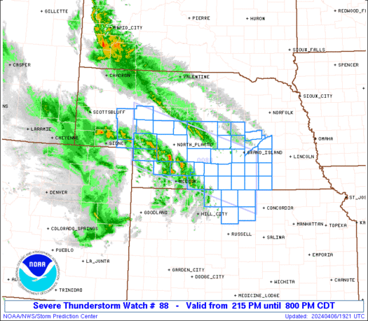
 URGENT - IMMEDIATE BROADCAST REQUESTED
Severe Thunderstorm Watch Number 88
NWS Storm Prediction Center Norman OK
1150 AM EDT Mon Mar 31 2025 The NWS Storm Prediction Center has issued a * Severe Thunderstorm Watch for portions of Far Southeast Alabama Florida Panhandle Southwest Georgia Coastal Waters * Effective this Monday morning and evening from 1150 AM until 600 PM EDT. * Primary threats include... Scattered damaging wind gusts to 65 mph possible A tornado or two possible SUMMARY...A squall line will move into the Watch from the west and a
risk for scattered damaging gusts (55-65 mph) may accompany more
intense portions of the line. The severe thunderstorm watch area is approximately along and 80
statute miles north and south of a line from 60 miles northwest of
Panama City FL to 25 miles south of Moultrie GA. For a complete
depiction of the watch see the associated watch outline update
(WOUS64 KWNS WOU8). PRECAUTIONARY/PREPAREDNESS ACTIONS... REMEMBER...A Severe Thunderstorm Watch means conditions are
favorable for severe thunderstorms in and close to the watch area.
Persons in these areas should be on the lookout for threatening
weather conditions and listen for later statements and possible
warnings. Severe thunderstorms can and occasionally do produce
tornadoes. && OTHER WATCH INFORMATION...CONTINUE...WW 84...WW 85...WW 86...WW
87... AVIATION...A few severe thunderstorms with hail surface and aloft to
1 inch. Extreme turbulence and surface wind gusts to 55 knots. A few
cumulonimbi with maximum tops to 450. Mean storm motion vector
27035. ...Smith 

Read more

SPC Severe Thunderstorm Watch 87 Status Reports

WW 0087 Status Updates
WW 0087 Status Image

 STATUS REPORT ON WW 66 THE SEVERE WEATHER THREAT CONTINUES ACROSS THE ENTIRE WATCH AREA. ..BROYLES..03/28/25 ATTN...WFO...LCH...SHV...HGX... STATUS REPORT FOR WT 66 SEVERE WEATHER THREAT CONTINUES FOR THE FOLLOWING AREAS LAC011-019-023-031-069-081-085-115-290040- LA . LOUISIANA PARISHES INCLUDED ARE BEAUREGARD CALCASIEU CAMERON DE SOTO NATCHITOCHES RED RIVER SABINE VERNON TXC005-199-241-245-291-347-351-361-373-403-405-419-457-290040- TX . TEXAS COUNTIES INCLUDED ARE ANGELINA HARDIN JASPER JEFFERSON LIBERTY NACOGDOCHES NEWTON ORANGE POLK SABINE SAN AUGUSTINE SHELBY TYLER GMZ430-432-290040- CW 

Read more

SPC Severe Thunderstorm Watch 87

WW 87 SEVERE TSTM GA NC SC 311530Z – 312300Z
WW 0087 Image

 URGENT - IMMEDIATE BROADCAST REQUESTED
Severe Thunderstorm Watch Number 87
NWS Storm Prediction Center Norman OK
1130 AM EDT Mon Mar 31 2025 The NWS Storm Prediction Center has issued a * Severe Thunderstorm Watch for portions of Central and Northern Georgia Western North Carolina Western and Central South Carolina * Effective this Monday morning and evening from 1130 AM until 700 PM EDT. * Primary threats include... Scattered damaging wind gusts to 70 mph likely Isolated large hail events to 1 inch in diameter possible A tornado or two possible SUMMARY...A squall line will move into the Watch area with the
primary hazard being damaging straight-line winds within bowing
portions of the line. A brief tornado is also possible if a
stronger embedded circulation in the squall line can develop. The severe thunderstorm watch area is approximately along and 115
statute miles east and west of a line from 35 miles north of
Greenville SC to 55 miles south southwest of Macon GA. For a
complete depiction of the watch see the associated watch outline
update (WOUS64 KWNS WOU7). PRECAUTIONARY/PREPAREDNESS ACTIONS... REMEMBER...A Severe Thunderstorm Watch means conditions are
favorable for severe thunderstorms in and close to the watch area.
Persons in these areas should be on the lookout for threatening
weather conditions and listen for later statements and possible
warnings. Severe thunderstorms can and occasionally do produce
tornadoes. && OTHER WATCH INFORMATION...CONTINUE...WW 84...WW 85...WW 86... AVIATION...A few severe thunderstorms with hail surface and aloft to
1 inch. Extreme turbulence and surface wind gusts to 60 knots. A few
cumulonimbi with maximum tops to 450. Mean storm motion vector
27045. ...Smith 

Read more

SPC Severe Thunderstorm Watch 86 Status Reports

WW 0086 Status Updates
WW 0086 Status Image

 STATUS REPORT ON WW 65 SEVERE WEATHER THREAT CONTINUES RIGHT OF A LINE FROM 15 SE AST TO
5 W SLE TO 45 ESE EUG. ..LYONS..03/27/25 ATTN...WFO...PQR...SEW... STATUS REPORT FOR WS 65 SEVERE WEATHER THREAT CONTINUES FOR THE FOLLOWING AREAS ORC005-009-027-043-047-051-067-071-270440- OR . OREGON COUNTIES INCLUDED ARE CLACKAMAS COLUMBIA HOOD RIVER LINN MARION MULTNOMAH WASHINGTON YAMHILL WAC011-015-033-041-053-059-067-270440- WA . WASHINGTON COUNTIES INCLUDED ARE CLARK COWLITZ KING LEWIS PIERCE SKAMANIA THURSTON THE WATCH STATUS MESSAGE IS FOR GUIDANCE PURPOSES ONLY. PLEASE
REFER TO WATCH COUNTY NOTIFICATION STATEMENTS FOR OFFICIAL
INFORMATION ON COUNTIES...INDEPENDENT CITIES AND MARINE ZONES
CLEARED FROM SEVERE THUNDERSTORM AND TORNADO WATCHES. 

Read more

SPC Severe Thunderstorm Watch 86

WW 86 SEVERE TSTM AL FL MS CW 311105Z – 311800Z
WW 0086 Image

 URGENT - IMMEDIATE BROADCAST REQUESTED
Severe Thunderstorm Watch Number 86
NWS Storm Prediction Center Norman OK
605 AM CDT Mon Mar 31 2025 The NWS Storm Prediction Center has issued a * Severe Thunderstorm Watch for portions of Southern Alabama The Western Florida Panhandle Southeast Mississippi Coastal Waters * Effective this Monday morning and afternoon from 605 AM until 100 PM CDT. * Primary threats include... Scattered damaging wind gusts to 70 mph likely Isolated large hail events to 1.5 inches in diameter possible A tornado or two possible SUMMARY...A line of thunderstorms will move eastward over the next
several hours. Scattered severe/damaging winds with peak gusts up to
60-70 mph should be the main threat, although a tornado or two may
also occur. The severe thunderstorm watch area is approximately along and 75
statute miles east and west of a line from 45 miles north northwest
of Evergreen AL to 30 miles southeast of Mobile AL. For a complete
depiction of the watch see the associated watch outline update
(WOUS64 KWNS WOU6). PRECAUTIONARY/PREPAREDNESS ACTIONS... REMEMBER...A Severe Thunderstorm Watch means conditions are
favorable for severe thunderstorms in and close to the watch area.
Persons in these areas should be on the lookout for threatening
weather conditions and listen for later statements and possible
warnings. Severe thunderstorms can and occasionally do produce
tornadoes. && OTHER WATCH INFORMATION...CONTINUE...WW 83...WW 84...WW 85... AVIATION...A few severe thunderstorms with hail surface and aloft to
1.5 inches. Extreme turbulence and surface wind gusts to 60 knots. A
few cumulonimbi with maximum tops to 500. Mean storm motion vector
27035. ...Gleason 

Read more

SPC Severe Thunderstorm Watch 85 Status Reports

WW 0085 Status Updates
WW 0085 Status Image

 STATUS REPORT ON WW 65 THE SEVERE WEATHER THREAT CONTINUES ACROSS THE ENTIRE WATCH AREA. ..LYONS..03/26/25 ATTN...WFO...PQR...SEW... STATUS REPORT FOR WS 65 SEVERE WEATHER THREAT CONTINUES FOR THE FOLLOWING AREAS ORC003-005-009-027-043-047-051-053-067-071-270040- OR . OREGON COUNTIES INCLUDED ARE BENTON CLACKAMAS COLUMBIA HOOD RIVER LINN MARION MULTNOMAH POLK WASHINGTON YAMHILL WAC011-015-033-041-053-059-067-270040- WA . WASHINGTON COUNTIES INCLUDED ARE CLARK COWLITZ KING LEWIS PIERCE SKAMANIA THURSTON THE WATCH STATUS MESSAGE IS FOR GUIDANCE PURPOSES ONLY. PLEASE
REFER TO WATCH COUNTY NOTIFICATION STATEMENTS FOR OFFICIAL
INFORMATION ON COUNTIES...INDEPENDENT CITIES AND MARINE ZONES
CLEARED FROM SEVERE THUNDERSTORM AND TORNADO WATCHES. 

Read more