Day: March 30, 2025
SPC Tornado Watch 81
WW 81 TORNADO AL AR MS TN 310355Z – 311000Z 
 URGENT - IMMEDIATE BROADCAST REQUESTED
Tornado Watch Number 81
NWS Storm Prediction Center Norman OK
1055 PM CDT Sun Mar 30 2025 The NWS Storm Prediction Center has issued a * Tornado Watch for portions of Northwest Alabama Far East-Central Arkansas Northern Mississippi Far Southern Middle Tennessee * Effective this Sunday night and Monday morning from 1055 PM until 500 AM CDT. * Primary threats include... A few tornadoes and a couple intense tornadoes possible Scattered damaging wind gusts to 70 mph likely Scattered large hail and isolated very large hail events to 2 inches in diameter possible SUMMARY...Strong to severe thunderstorms are expected to continue
eastward/southeastward into the region tonight. Environmental
conditions support the potential strong wind gusts and large hail
with storms embedded within the approaching convective line. Some
line-embedded tornadoes could occur as well. Additionally, a few
supercells are also possible, particularly over northern MS. These
supercells would be capable of all severe hazards, including very
large hail and tornadoes. The tornado watch area is approximately along and 110 statute miles
east and west of a line from 45 miles west northwest of Muscle
Shoals AL to 55 miles south of Oxford MS. For a complete depiction
of the watch see the associated watch outline update (WOUS64 KWNS
WOU1). PRECAUTIONARY/PREPAREDNESS ACTIONS... REMEMBER...A Tornado Watch means conditions are favorable for
tornadoes and severe thunderstorms in and close to the watch
area. Persons in these areas should be on the lookout for
threatening weather conditions and listen for later statements
and possible warnings. && OTHER WATCH INFORMATION...CONTINUE...WW 72...WW 76...WW 77...WW
78...WW 79...WW 80... AVIATION...Tornadoes and a few severe thunderstorms with hail
surface and aloft to 2 inches. Extreme turbulence and surface wind
gusts to 60 knots. A few cumulonimbi with maximum tops to 500. Mean
storm motion vector 34035. ...Mosier
SPC Severe Thunderstorm Watch 80
WW 80 SEVERE TSTM KY OH VA WV 310255Z – 311000Z 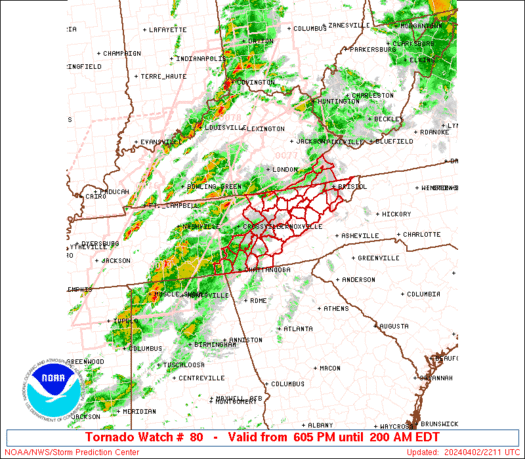
 URGENT - IMMEDIATE BROADCAST REQUESTED
Severe Thunderstorm Watch Number 80
NWS Storm Prediction Center Norman OK
1055 PM EDT Sun Mar 30 2025 The NWS Storm Prediction Center has issued a * Severe Thunderstorm Watch for portions of Eastern Kentucky Far Southern Ohio Far Western Virginia Western West Virginia * Effective this Sunday night and Monday morning from 1055 PM until 600 AM EDT. * Primary threats include... Scattered damaging wind gusts to 70 mph likely Isolated large hail events to 1 inch in diameter possible A tornado or two possible SUMMARY...The threat for damaging wind gusts will continue into the
region as the ongoing convective line progresses eastward. The severe thunderstorm watch area is approximately along and 60
statute miles east and west of a line from 40 miles north of
Charleston WV to 30 miles southeast of London KY. For a complete
depiction of the watch see the associated watch outline update
(WOUS64 KWNS WOU0). PRECAUTIONARY/PREPAREDNESS ACTIONS... REMEMBER...A Severe Thunderstorm Watch means conditions are
favorable for severe thunderstorms in and close to the watch area.
Persons in these areas should be on the lookout for threatening
weather conditions and listen for later statements and possible
warnings. Severe thunderstorms can and occasionally do produce
tornadoes. && OTHER WATCH INFORMATION...CONTINUE...WW 72...WW 74...WW 76...WW
77...WW 78...WW 79... AVIATION...A few severe thunderstorms with hail surface and aloft to
1 inch. Extreme turbulence and surface wind gusts to 60 knots. A few
cumulonimbi with maximum tops to 500. Mean storm motion vector
27040. ...Mosier
Severe Storm Threat in East Texas Overnight

Scattered strong to severe thunderstorms have erupted across parts of East Texas this evening, after hours of waiting for things to begin. I wasn’t entirely sure they would start, but they finally did. We have heavy storms with hail and heavy rain on Highway 79 from Jacksonville up to Henderson. Another small cluster of severe […]
SPC Severe Thunderstorm Watch 79 Status Reports
WW 0079 Status Updates 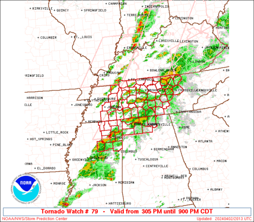
 STATUS REPORT ON WW 59 SEVERE WEATHER THREAT CONTINUES RIGHT OF A LINE FROM 40 ESE BMG
TO 20 SW FWA TO 30 NW FWA TO 20 SSW JXN. ..HART..03/20/25 ATTN...WFO...IWX...IND...ILN...GRR... STATUS REPORT FOR WS 59 SEVERE WEATHER THREAT CONTINUES FOR THE FOLLOWING AREAS INC001-003-009-029-031-033-035-041-047-053-059-065-069-075-095-
113-115-135-137-139-151-155-161-177-179-183-200340- IN . INDIANA COUNTIES INCLUDED ARE ADAMS ALLEN BLACKFORD DEARBORN DECATUR DE KALB DELAWARE FAYETTE FRANKLIN GRANT HANCOCK HENRY HUNTINGTON JAY MADISON NOBLE OHIO RANDOLPH RIPLEY RUSH STEUBEN SWITZERLAND UNION WAYNE WELLS WHITLEY KYC015-037-041-077-081-117-187-191-200340- KY . KENTUCKY COUNTIES INCLUDED ARE BOONE CAMPBELL CARROLL GALLATIN GRANT KENTON OWEN PENDLETON
SPC Severe Thunderstorm Watch 79
WW 79 SEVERE TSTM OH PA WV 310210Z – 310700Z
 URGENT - IMMEDIATE BROADCAST REQUESTED
Severe Thunderstorm Watch Number 79
NWS Storm Prediction Center Norman OK
1010 PM EDT Sun Mar 30 2025 The NWS Storm Prediction Center has issued a * Severe Thunderstorm Watch for portions of Eastern Ohio Far Southwestern Pennsylvania Northwestern West Virginia * Effective this Sunday night and Monday morning from 1010 PM until 300 AM EDT. * Primary threats include... Scattered damaging wind gusts to 70 mph likely Isolated large hail events to 1 inch in diameter possible A tornado or two possible SUMMARY...Ongoing convective line is expected to continue quickly
eastward over the next few hours. Some strong to occasionally severe
gusts are possible within this line. The severe thunderstorm watch area is approximately along and 60
statute miles east and west of a line from 30 miles north of Akron
OH to 25 miles south southwest of Parkersburg WV. For a complete
depiction of the watch see the associated watch outline update
(WOUS64 KWNS WOU9). PRECAUTIONARY/PREPAREDNESS ACTIONS... REMEMBER...A Severe Thunderstorm Watch means conditions are
favorable for severe thunderstorms in and close to the watch area.
Persons in these areas should be on the lookout for threatening
weather conditions and listen for later statements and possible
warnings. Severe thunderstorms can and occasionally do produce
tornadoes. && OTHER WATCH INFORMATION...CONTINUE...WW 72...WW 74...WW 76...WW
77...WW 78... AVIATION...A few severe thunderstorms with hail surface and aloft to
1 inch. Extreme turbulence and surface wind gusts to 60 knots. A few
cumulonimbi with maximum tops to 500. Mean storm motion vector
26045. ...Mosier
Final Four forecast: Unexpected weather in San Antonio adds to the chaos of March Madness
March is a month known for its unpredictability, from the weather to your odds of filling out a perfect March Madness bracket.
SPC Tornado Watch 78 Status Reports
WW 0078 Status Updates 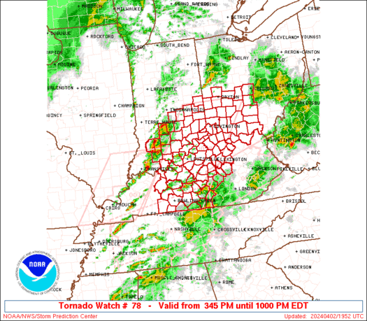
 STATUS REPORT ON WW 58 SEVERE WEATHER THREAT CONTINUES RIGHT OF A LINE FROM 40 ENE DYR
TO 25 NNE SLO. FOR ADDITIONAL INFORMATION SEE MESOSCALE DISCUSSION 0248 ..MOORE..03/19/25 ATTN...WFO...PAH...LMK... STATUS REPORT FOR WT 58 SEVERE WEATHER THREAT CONTINUES FOR THE FOLLOWING AREAS ILC047-059-065-069-151-165-185-191-193-200040- IL . ILLINOIS COUNTIES INCLUDED ARE EDWARDS GALLATIN HAMILTON HARDIN POPE SALINE WABASH WAYNE WHITE INC019-025-037-043-051-061-077-117-123-125-129-143-147-163-173-
175-200040- IN . INDIANA COUNTIES INCLUDED ARE CLARK CRAWFORD DUBOIS FLOYD GIBSON HARRISON JEFFERSON ORANGE PERRY PIKE POSEY SCOTT SPENCER VANDERBURGH WARRICK WASHINGTON
SPC Tornado Watch 78
WW 78 TORNADO KY TN 310125Z – 310800Z
 URGENT - IMMEDIATE BROADCAST REQUESTED
Tornado Watch Number 78
NWS Storm Prediction Center Norman OK
825 PM CDT Sun Mar 30 2025 The NWS Storm Prediction Center has issued a * Tornado Watch for portions of Central Kentucky Western and Middle Tennessee * Effective this Sunday night and Monday morning from 825 PM until 300 AM CDT. * Primary threats include... A few tornadoes likely with a couple intense tornadoes possible Scattered damaging wind gusts to 70 mph likely Scattered large hail and isolated very large hail events to 2 inches in diameter possible SUMMARY...Strong to severe thunderstorms are ongoing within a
convective line that extends from southern IN through western KY
into western TN. This line is expected to continue eastward into the
moist and moderately unstable airmass downstream across central KY
and western/middle TN. The environment supports a continuation of
the ongoing strong to severe storms. Persistent moderate to strong
low-level shear will support the potential for tornadoes embedded
within this line. Large hail and strong gusts are possible as well. The tornado watch area is approximately along and 60 statute miles
east and west of a line from 45 miles northeast of Bowling Green KY
to 105 miles southwest of Nashville TN. For a complete depiction of
the watch see the associated watch outline update (WOUS64 KWNS
WOU8). PRECAUTIONARY/PREPAREDNESS ACTIONS... REMEMBER...A Tornado Watch means conditions are favorable for
tornadoes and severe thunderstorms in and close to the watch
area. Persons in these areas should be on the lookout for
threatening weather conditions and listen for later statements
and possible warnings. && OTHER WATCH INFORMATION...CONTINUE...WW 72...WW 74...WW 75...WW
76...WW 77... AVIATION...Tornadoes and a few severe thunderstorms with hail
surface and aloft to 2 inches. Extreme turbulence and surface wind
gusts to 60 knots. A few cumulonimbi with maximum tops to 500. Mean
storm motion vector 27040. ...Mosier