Earth dodges massive solar storm, with space experts watching for more activity

Earth dodges massive solar storm, with space experts watching for more activity

Space experts are watching a sunspot region known as AR4046 which recently produced a significant solar flare and coronal mass ejection that had the potential to be as significant as the solar storm of Halloween 2003 or the one that occurred in May 2024. In 2003, NASA said at the time the event affected orbiting spacecrafts, disrupted satellite TV and radio services and disrupted some airline flight communications.

SPC Tornado Watch 68

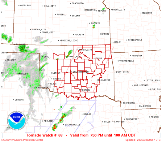
WW 68 TORNADO OK 300050Z – 300600Z
WW 0068 Image

 URGENT - IMMEDIATE BROADCAST REQUESTED
Tornado Watch Number 68
NWS Storm Prediction Center Norman OK
750 PM CDT Sat Mar 29 2025 The NWS Storm Prediction Center has issued a * Tornado Watch for portions of Central and Eastern/Northeastern Oklahoma * Effective this Saturday night and Sunday morning from 750 PM until 100 AM CDT. * Primary threats include... A couple tornadoes possible Scattered damaging winds and isolated significant gusts to 80 mph possible Scattered large hail and isolated very large hail events to 2.5 inches in diameter possible SUMMARY...Thunderstorms are expected to develop across the region as
a cold front moves eastward through central OK. Environmental
conditions support the development of strong to severe
thunderstorms, including the potential for a few supercells. All
severe hazards are possible, including very large hail, strong wind
gusts over 70 mph, and tornadoes. The tornado watch area is approximately along and 75 statute miles
east and west of a line from 20 miles west southwest of Ardmore OK
to 15 miles east northeast of Bartlesville OK. For a complete
depiction of the watch see the associated watch outline update
(WOUS64 KWNS WOU8). PRECAUTIONARY/PREPAREDNESS ACTIONS... REMEMBER...A Tornado Watch means conditions are favorable for
tornadoes and severe thunderstorms in and close to the watch
area. Persons in these areas should be on the lookout for
threatening weather conditions and listen for later statements
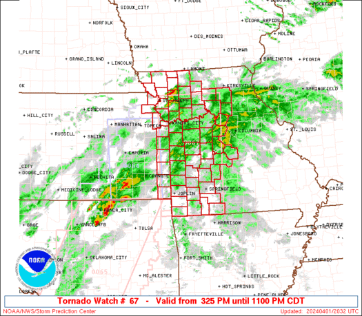
and possible warnings. && OTHER WATCH INFORMATION...CONTINUE...WW 67... AVIATION...Tornadoes and a few severe thunderstorms with hail
surface and aloft to 2.5 inches. Extreme turbulence and surface wind
gusts to 70 knots. A few cumulonimbi with maximum tops to 500. Mean
storm motion vector 24035. ...Mosier 

Read more

SPC Severe Thunderstorm Watch 67

WW 67 SEVERE TSTM TX 300015Z – 300700Z
WW 0067 Image

 URGENT - IMMEDIATE BROADCAST REQUESTED
Severe Thunderstorm Watch Number 67
NWS Storm Prediction Center Norman OK
715 PM CDT Sat Mar 29 2025 The NWS Storm Prediction Center has issued a * Severe Thunderstorm Watch for portions of Central and North Texas * Effective this Saturday night and Sunday morning from 715 PM until 200 AM CDT. * Primary threats include... Scattered large hail and isolated very large hail events to 2.5 inches in diameter possible Isolated damaging wind gusts to 70 mph possible SUMMARY...Thunderstorm coverage is expected to increase over the
next few hours as a shortwave trough moves eastward into the region.
Steep mid-level lapse rates will help support moderate to strong
buoyancy in the presence of moderate deep-layer vertical shear.
These environmental conditions could support severe thunderstorms
capable of large to very large hail and strong wind gusts this
evening. The severe thunderstorm watch area is approximately along and 60
statute miles east and west of a line from 50 miles south of
Brownwood TX to 55 miles north of Dallas TX. For a complete
depiction of the watch see the associated watch outline update
(WOUS64 KWNS WOU7). PRECAUTIONARY/PREPAREDNESS ACTIONS... REMEMBER...A Severe Thunderstorm Watch means conditions are
favorable for severe thunderstorms in and close to the watch area.
Persons in these areas should be on the lookout for threatening
weather conditions and listen for later statements and possible
warnings. Severe thunderstorms can and occasionally do produce
tornadoes. && AVIATION...A few severe thunderstorms with hail surface and aloft to
2.5 inches. Extreme turbulence and surface wind gusts to 60 knots. A
few cumulonimbi with maximum tops to 500. Mean storm motion vector
24030. ...Mosier 

Read more

Satellite images reveal scope of destruction from Myanmar’s devasting earthquake

Satellite images reveal scope of destruction from Myanmar’s devasting earthquake

The most destructive earthquake in more than 100 years to strike Myanmar occurred on March 28, 2025. Government estimates indicate that thousands of people could be dead following the 7.7 magnitude event. Satellite imagery from Maxar showed before and after images of damaged homes and neighborhoods in what is considered to be one of the poorest countries in Southeast Asia.