SPC – No watches are valid as of Thu Mar 27 04:02:02 UTC 2025
No watches are valid as of Thu Mar 27 04:02:02 UTC 2025.
24/7 Tornado Newsfeed
No watches are valid as of Thu Mar 27 04:02:02 UTC 2025.

NASAâs James Webb Space Telescope has captured the first-ever clear images of auroral activity on Neptune, the 8th planet from the Sun. For years, scientists had only speculated about the presence of auroras on Neptune. The planet now joins half a dozen others in our solar system where auroras have been observed.
![Texas Severe Thunderstorm & Flooding Evening Nowcast [3/26/25]](https://i0.wp.com/texasstormchasers.com/wp-content/uploads/2025/03/Texas-Severe-Thunderstorm-Flooding-Evening-Nowcast-32625.jpg?w=1920&resize=1920,0&ssl=1 "Texas Severe Thunderstorm & Flooding Evening Nowcast [3/26/25]")
Numerous showers and heavy thunderstorms will continue overnight across the Rio Grande Plains, South Texas, Rio Grande Valley, and Coastal Bend. While a few storms may become severe, we expect heavy rain and localized flooding to be a more significant concern in the aforementioned regions into Thursday. There will still be some risk of severe […]

The Florida Fish and Wildlife Conservation Commission announced on Wednesday that it has closed the Unusual Mortality Event case involving dead manatees along the Florida coastline. The agency said manatees in the affected area are no longer starving and that mortality numbers have dropped significantly enough to warrant the closure of the investigation.
WW 65 SEVERE TSTM OR WA 262210Z – 270400Z 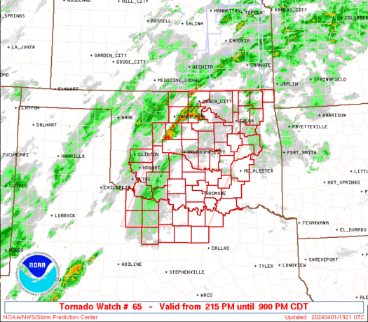
 URGENT - IMMEDIATE BROADCAST REQUESTED
Severe Thunderstorm Watch Number 65
NWS Storm Prediction Center Norman OK
310 PM PDT Wed Mar 26 2025 The NWS Storm Prediction Center has issued a * Severe Thunderstorm Watch for portions of Northwest Oregon Western Washington * Effective this Wednesday afternoon and evening from 310 PM until 900 PM PDT. * Primary threats include... Scattered large hail and isolated very large hail events to 2 inches in diameter likely Scattered damaging wind gusts to 70 mph possible A tornado or two possible SUMMARY...Thunderstorms are expected to develop this afternoon over
parts of northwest Oregon and track north-northeastward across the
watch area through early evening. Large hail and damaging wind
gusts are possible in the strongest cells. The severe thunderstorm watch area is approximately along and 45
statute miles east and west of a line from 45 miles south of Salem
OR to 5 miles north northwest of Seattle WA. For a complete
depiction of the watch see the associated watch outline update
(WOUS64 KWNS WOU5). PRECAUTIONARY/PREPAREDNESS ACTIONS... REMEMBER...A Severe Thunderstorm Watch means conditions are
favorable for severe thunderstorms in and close to the watch area.
Persons in these areas should be on the lookout for threatening
weather conditions and listen for later statements and possible
warnings. Severe thunderstorms can and occasionally do produce
tornadoes. && AVIATION...A few severe thunderstorms with hail surface and aloft to
2 inches. Extreme turbulence and surface wind gusts to 60 knots. A
few cumulonimbi with maximum tops to 500. Mean storm motion vector
22030. ...Hart

If you missed your chance earlier this week to see the Northern Lights, the geomagnetic storm continues on Wednesday to increase the likelihood of aurora lights along the northern U.S.

Hail comes in a variety of sizes, and most people don't look forward to hearing large hail is a possibility during severe weather, fearing damage to their cars or homes.

Orange juice, once a staple in American kitchens and known for its vitamin C, has seen a dramatic decline in popularity, which comes at a tumultuous time for the industry facing headwinds from trade wars, climate change and citrus greening.
 Science with Sarah: Carbon Sugar Snakes

Are you looking for something fun to do at home that has a little bit of science behind it? This carbon sugar snake is a great way to show chemical reactions.