Teen dies after Alaska avalanche buries him in nearly 15 feet of snow

A devastating death has occurred in Alaska following an avalanche.
24/7 Tornado Newsfeed
A devastating death has occurred in Alaska following an avalanche.

Beachgoers in North Carolina were recently met by a big surprise guest.

The famous Washington, D.C., cherry blossoms have entered the fifth stage of the blooming process, one step closer to peak bloom.

Night owls could see dashes of glowing color in the sky early Tuesday morning with a Geomagnetic Storm Watch in place, signaling the possible arrival of the Northern Lights.

A pair of North American river otters have apparently decided one Wisconsin zoo isn't cutting it for winter fun.

The FOX Forecast Center is continuing to track a line of powerful thunderstorms sweeping across the Deep South and Gulf Coast one day after storms left trails of damage from Texas to Kentucky.

A stark temperature divide splits the U.S. this week with record-breaking heat and dryness scorching the West while the East grapples with cold and unsettled conditions.
WW 0064 Status Updates 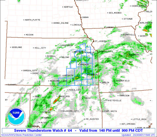
 STATUS REPORT ON WW 28 SEVERE WEATHER THREAT CONTINUES RIGHT OF A LINE FROM 40 ESE EWN
TO 30 N ORF. ..SPC..03/05/25 ATTN...WFO...MHX...AKQ...RAH... STATUS REPORT FOR WT 28 SEVERE WEATHER THREAT CONTINUES FOR THE FOLLOWING AREAS NCC053-055-095-139-177-052340- NC . NORTH CAROLINA COUNTIES INCLUDED ARE CURRITUCK DARE HYDE PASQUOTANK TYRRELL VAC710-810-052340- VA . VIRGINIA COUNTIES INCLUDED ARE VIRGINIA INDEPENDENT CITIES INCLUDED ARE NORFOLK VIRGINIA BEACH AMZ131-135-150-152-154-156-230-231-ANZ632-633-634-656-658-
052340-
WW 64 SEVERE TSTM LA MS CW 241125Z – 241600Z
 URGENT - IMMEDIATE BROADCAST REQUESTED
Severe Thunderstorm Watch Number 64
NWS Storm Prediction Center Norman OK
625 AM CDT Mon Mar 24 2025 The NWS Storm Prediction Center has issued a * Severe Thunderstorm Watch for portions of Southern Louisiana Far Southeast Mississippi Coastal Waters * Effective this Monday morning from 625 AM until 1100 AM CDT. * Primary threats include... Scattered damaging winds likely with isolated significant gusts to 75 mph possible A tornado or two possible SUMMARY...A well-organized bowing line of storms will continue
steadily east-northeastward this morning with wind damage as the
primary hazard. The severe thunderstorm watch area is approximately along and 50
statute miles north and south of a line from 65 miles northwest of
Houma LA to 35 miles east southeast of Slidell LA. For a complete
depiction of the watch see the associated watch outline update
(WOUS64 KWNS WOU4). PRECAUTIONARY/PREPAREDNESS ACTIONS... REMEMBER...A Severe Thunderstorm Watch means conditions are
favorable for severe thunderstorms in and close to the watch area.
Persons in these areas should be on the lookout for threatening
weather conditions and listen for later statements and possible
warnings. Severe thunderstorms can and occasionally do produce
tornadoes. && AVIATION...A few severe thunderstorms with hail surface and aloft to
1 inch. Extreme turbulence and surface wind gusts to 65 knots. A few
cumulonimbi with maximum tops to 500. Mean storm motion vector
25045. ...Guyer

Top weather news for Monday, March 24, 2025: The central and eastern Gulf Coast, including New Orleans, will be bracing for severe weather on Monday one day after tornado-ravaged communities in the South were slammed by powerful thunderstorms.