Fishermen reel in massive great white shark catch on Outer Banks beach

A team of North Carolina fishermen had the catch of a lifetime this month when they reeled in a 12-foot great white shark from the surf of the Atlantic Ocean.
24/7 Tornado Newsfeed
A team of North Carolina fishermen had the catch of a lifetime this month when they reeled in a 12-foot great white shark from the surf of the Atlantic Ocean.
WW 0061 Status Updates 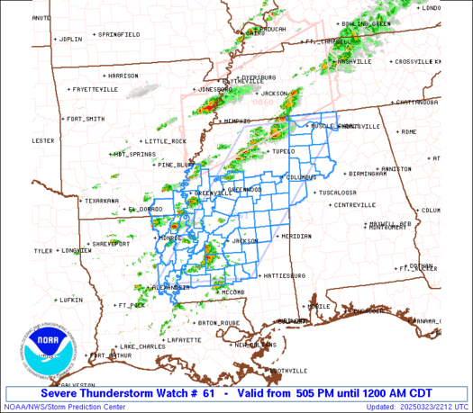
 STATUS REPORT ON WW 15 SEVERE WEATHER THREAT CONTINUES RIGHT OF A LINE FROM 40 NNW MWL
TO 15 ESE LTS TO 20 NW CSM. ..LEITMAN..03/02/25 ATTN...WFO...OUN... STATUS REPORT FOR WS 15 SEVERE WEATHER THREAT CONTINUES FOR THE FOLLOWING AREAS OKC031-033-075-141-149-030040- OK . OKLAHOMA COUNTIES INCLUDED ARE COMANCHE COTTON KIOWA TILLMAN WASHITA TXC077-485-030040- TX . TEXAS COUNTIES INCLUDED ARE CLAY WICHITA THE WATCH STATUS MESSAGE IS FOR GUIDANCE PURPOSES ONLY. PLEASE
REFER TO WATCH COUNTY NOTIFICATION STATEMENTS FOR OFFICIAL
INFORMATION ON COUNTIES...INDEPENDENT CITIES AND MARINE ZONES
CLEARED FROM SEVERE THUNDERSTORM AND TORNADO WATCHES.
WW 61 SEVERE TSTM AL AR LA MS 232205Z – 240500Z
 URGENT - IMMEDIATE BROADCAST REQUESTED
Severe Thunderstorm Watch Number 61
NWS Storm Prediction Center Norman OK
505 PM CDT Sun Mar 23 2025 The NWS Storm Prediction Center has issued a * Severe Thunderstorm Watch for portions of Northwest Alabama Southeast Arkansas Northeast Louisiana Central Mississippi * Effective this Sunday afternoon from 505 PM until Midnight CDT. * Primary threats include... Scattered large hail likely with isolated very large hail events to 2.5 inches in diameter possible Scattered damaging wind gusts to 70 mph possible A tornado or two possible SUMMARY...Scattered severe thunderstorms capable of producing large
to very large hail around 1.5-2.5 inches in diameter are expected to
develop and spread eastward through the evening. Damaging winds up
to 60-70 mph may also occur, especially if convection can develop
into a line. A tornado or two also appears possible. The severe thunderstorm watch area is approximately along and 75
statute miles east and west of a line from 25 miles west northwest
of Muscle Shoals AL to 30 miles east southeast of Natchez MS. For a
complete depiction of the watch see the associated watch outline
update (WOUS64 KWNS WOU1). PRECAUTIONARY/PREPAREDNESS ACTIONS... REMEMBER...A Severe Thunderstorm Watch means conditions are
favorable for severe thunderstorms in and close to the watch area.
Persons in these areas should be on the lookout for threatening
weather conditions and listen for later statements and possible
warnings. Severe thunderstorms can and occasionally do produce
tornadoes. && OTHER WATCH INFORMATION...CONTINUE...WW 60... AVIATION...A few severe thunderstorms with hail surface and aloft to
2.5 inches. Extreme turbulence and surface wind gusts to 60 knots. A
few cumulonimbi with maximum tops to 500. Mean storm motion vector
26035. ...Gleason
WW 60 TORNADO AR KY MO MS TN 232015Z – 240400Z 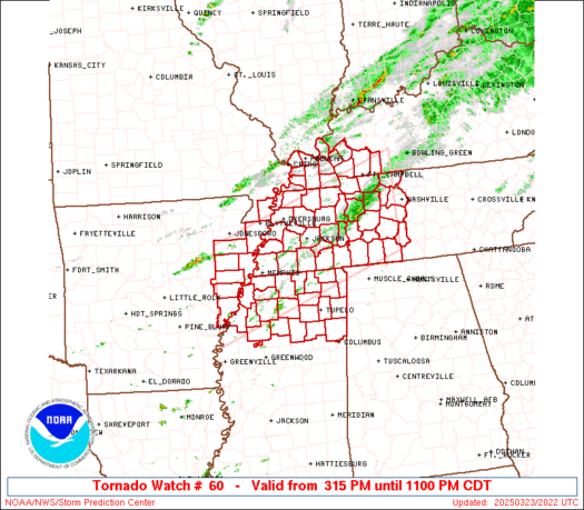
 URGENT - IMMEDIATE BROADCAST REQUESTED
Tornado Watch Number 60
NWS Storm Prediction Center Norman OK
315 PM CDT Sun Mar 23 2025 The NWS Storm Prediction Center has issued a * Tornado Watch for portions of Eastern Arkansas Southwest Kentucky Missouri Bootheel Northern Mississippi Western and Middle Tennessee * Effective this Sunday afternoon and evening from 315 PM until 1100 PM CDT. * Primary threats include... A few tornadoes possible Scattered large hail and isolated very large hail events to 2 inches in diameter possible Scattered damaging wind gusts to 70 mph possible SUMMARY...Thunderstorms are expected to intensify this afternoon
over eastern Arkansas and spread eastward across the watch area
through the evening. Large hail and damaging winds will be the main
concern with these storms. However, sufficient low level shear will
pose some risk of a few tornadoes. The tornado watch area is approximately along and 65 statute miles
north and south of a line from 65 miles west southwest of Memphis TN
to 45 miles southeast of Clarksville TN. For a complete depiction of
the watch see the associated watch outline update (WOUS64 KWNS
WOU0). PRECAUTIONARY/PREPAREDNESS ACTIONS... REMEMBER...A Tornado Watch means conditions are favorable for
tornadoes and severe thunderstorms in and close to the watch
area. Persons in these areas should be on the lookout for
threatening weather conditions and listen for later statements
and possible warnings. && AVIATION...Tornadoes and a few severe thunderstorms with hail
surface and aloft to 2 inches. Extreme turbulence and surface wind
gusts to 60 knots. A few cumulonimbi with maximum tops to 500. Mean
storm motion vector 25030. ...Hart

Three deer in Wisconsin found themselves in a rescue operation after plunging into freezing waters.

With the new season, The Old Farmerâs Almanac and the Farmersâ Almanac have both released their spring weather outlooks to help planters and families plan their calendars in the months ahead.

Three wildfires in western North Carolina are proving challenging for firefighters to beat because of rough terrain and debris left behind by Hurricane Helene.

Alaskaâs Mount Spurr volcano continues to show signs of unrest, and that has led to an alert level increase in the city of Anchorage as fears of an impending eruption grow.

A cool front moving south across Texas today will trigger isolated to scattered severe storms this evening in Central Texas, the Brazos Valley, Northeast Texas, and East Texas. We are not expecting a solid line of storms, which means not everyone will receive rain this evening. The best chance for scattered storms will be in […]