Texas Severe Thunderstorm Update [10 PM 3/23/25]

Texas Severe Thunderstorm Update [10 PM 3/23/25]

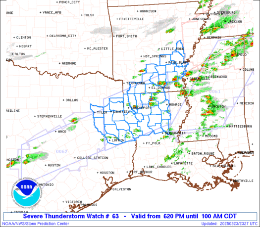
Two lines of thunderstorms are making their way south and southeast across the beautiful Hill Country, Central Texas, Brazos Valley, and East Texas! One line is currently affecting the vibrant San Antonio and Austin regions, while a second line is forming along the cool front stretching from Jarrell to Rosebud to Kosse to Buffalo. Both […]

Texas Severe Weather Update [7 PM 3/23/25]

Texas Severe Weather Update [7 PM 3/23/25]

Severe storms are developing near and ahead of a cool front extending from the Hill Country and Central Texas, across the Brazos Valley, into southeastern North Texas and East Texas. These storms are generally moving east at 20-25 MPH, with some heading southeast and others northeast. The most intense storms may produce hail ranging from […]

SPC Severe Thunderstorm Watch 63 Status Reports

WW 0063 Status Updates
WW 0063 Status Image

 STATUS REPORT ON WW 21 SEVERE WEATHER THREAT CONTINUES RIGHT OF A LINE FROM 30 WNW HEZ
TO 50 S GLH TO 25 NE GLH. ..SUPINIE..03/04/25 ATTN...WFO...LIX...LCH...JAN...MOB... STATUS REPORT FOR WT 21 SEVERE WEATHER THREAT CONTINUES FOR THE FOLLOWING AREAS LAC005-007-009-025-029-033-037-045-047-051-055-057-063-065-071-
075-077-087-089-091-093-095-097-099-101-103-105-107-109-117-121-
125-042140- LA . LOUISIANA PARISHES INCLUDED ARE ASCENSION ASSUMPTION AVOYELLES CATAHOULA CONCORDIA EAST BATON ROUGE EAST FELICIANA IBERIA IBERVILLE JEFFERSON LAFAYETTE LAFOURCHE LIVINGSTON MADISON ORLEANS PLAQUEMINES POINTE COUPEE ST. BERNARD ST. CHARLES ST. HELENA ST. JAMES ST. JOHN THE BAPTIST ST. LANDRY ST. MARTIN ST. MARY ST. TAMMANY TANGIPAHOA TENSAS TERREBONNE WASHINGTON WEST BATON ROUGE WEST FELICIANA MSC001-005-007-015-019-021-023-025-029-031-035-037-039-041-043-
045-047-049-051-053-055-059-061-063-065-067-069-073-075-077-079-
083-085-087-089-091-097-099-101-103-105-109-111-113-121-123-125-
127-129-131-133-147-149-153-155-157-159-163-042140- 

Read more

SPC Severe Thunderstorm Watch 63

WW 63 SEVERE TSTM AR LA TX 232320Z – 240600Z
WW 0063 Image

 URGENT - IMMEDIATE BROADCAST REQUESTED
Severe Thunderstorm Watch Number 63
NWS Storm Prediction Center Norman OK
620 PM CDT Sun Mar 23 2025 The NWS Storm Prediction Center has issued a * Severe Thunderstorm Watch for portions of Southen and East-Central Arkansas Northern Louisiana East Texas * Effective this Sunday night and Monday morning from 620 PM until 100 AM CDT. * Primary threats include... Scattered large hail likely with isolated very large hail events to 2.5 inches in diameter possible Scattered damaging wind gusts to 70 mph possible A tornado or two possible SUMMARY...Thunderstorms will continue to develop along and ahead of
a cold front this evening. Supercells will be capable of producing
scattered large hail, with the largest stones potentially reaching
up to 1.5-2.5 inches in diameter. Damaging winds may also occur with
any clusters that form later this evening. The severe thunderstorm watch area is approximately along and 70
statute miles north and south of a line from 20 miles north
northeast of Monroe LA to 40 miles south southwest of Longview TX.
For a complete depiction of the watch see the associated watch
outline update (WOUS64 KWNS WOU3). PRECAUTIONARY/PREPAREDNESS ACTIONS... REMEMBER...A Severe Thunderstorm Watch means conditions are
favorable for severe thunderstorms in and close to the watch area.
Persons in these areas should be on the lookout for threatening
weather conditions and listen for later statements and possible
warnings. Severe thunderstorms can and occasionally do produce
tornadoes. && OTHER WATCH INFORMATION...CONTINUE...WW 60...WW 61...WW 62... AVIATION...A few severe thunderstorms with hail surface and aloft to
2.5 inches. Extreme turbulence and surface wind gusts to 60 knots. A
few cumulonimbi with maximum tops to 500. Mean storm motion vector
26030. ...Gleason 

Read more

Severe Storm Watch until 1 AM Monday for Hill Country, Central Texas, Brazos Valley

Severe Storm Watch until 1 AM Monday for Hill Country, Central Texas, Brazos Valley

A severe thunderstorm watch is in effect until 1 AM Monday for the Hill Country, Central Texas, and Brazos Valley. This watch covers Fredericksburg, Kingsland, San Marcos, Austin, Killeen, Waco, College Station, Brenham, Palestine, and Gun Barrel City. We anticipate scattered severe storms developing over the next few hours near a slow-moving cool front. The […]

SPC Severe Thunderstorm Watch 62

WW 62 SEVERE TSTM TX 232250Z – 240600Z
WW 0062 Image

 URGENT - IMMEDIATE BROADCAST REQUESTED
Severe Thunderstorm Watch Number 62
NWS Storm Prediction Center Norman OK
550 PM CDT Sun Mar 23 2025 The NWS Storm Prediction Center has issued a * Severe Thunderstorm Watch for portions of Central Texas * Effective this Sunday afternoon and Monday morning from 550 PM until 100 AM CDT. * Primary threats include... Scattered large hail likely with isolated very large hail events to 2.5 inches in diameter possible Scattered damaging wind gusts to 70 mph possible SUMMARY...Thunderstorms are expected to continue developing along a
cold front through the evening, while posing a threat for mainly
scattered large hail up to 1.5-2.5 inches in diameter. Some risk for
strong to severe winds, potentially up to 60-70 mph, will also exist
if small clusters can form. The severe thunderstorm watch area is approximately along and 55
statute miles north and south of a line from 65 miles west of Austin
TX to 70 miles north northeast of Huntsville TX. For a complete
depiction of the watch see the associated watch outline update
(WOUS64 KWNS WOU2). PRECAUTIONARY/PREPAREDNESS ACTIONS... REMEMBER...A Severe Thunderstorm Watch means conditions are
favorable for severe thunderstorms in and close to the watch area.
Persons in these areas should be on the lookout for threatening
weather conditions and listen for later statements and possible
warnings. Severe thunderstorms can and occasionally do produce
tornadoes. && OTHER WATCH INFORMATION...CONTINUE...WW 60...WW 61... AVIATION...A few severe thunderstorms with hail surface and aloft to
2.5 inches. Extreme turbulence and surface wind gusts to 60 knots. A
few cumulonimbi with maximum tops to 500. Mean storm motion vector
27030. ...Gleason 

Read more