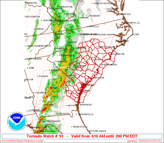
SPC Tornado Watch 53

WW 53 TORNADO OH PA WV 161430Z – 162000Z
WW 0053 Image

 URGENT - IMMEDIATE BROADCAST REQUESTED
Tornado Watch Number 53
NWS Storm Prediction Center Norman OK
1030 AM EDT Sun Mar 16 2025 The NWS Storm Prediction Center has issued a * Tornado Watch for portions of Eastern Ohio Western Pennsylvania West Virginia * Effective this Sunday morning and afternoon from 1030 AM until 400 PM EDT. * Primary threats include... A few tornadoes possible Scattered damaging wind gusts to 70 mph likely SUMMARY...Multiple lines and clusters of thunderstorms will continue
to develop and intensify as they move quickly northeastward late
this morning and into the afternoon. Scattered damaging winds will
likely be the main threat with this activity, with peak gusts
perhaps reaching up to 60-70 mph. But, the environment will also
support some threat for a few line-embedded tornadoes as well. The tornado watch area is approximately along and 60 statute miles
east and west of a line from 30 miles northwest of Franklin PA to 40
miles south southeast of Charleston WV. For a complete depiction of
the watch see the associated watch outline update (WOUS64 KWNS
WOU3). PRECAUTIONARY/PREPAREDNESS ACTIONS... REMEMBER...A Tornado Watch means conditions are favorable for
tornadoes and severe thunderstorms in and close to the watch
area. Persons in these areas should be on the lookout for
threatening weather conditions and listen for later statements
and possible warnings. && OTHER WATCH INFORMATION...CONTINUE...WW 51...WW 52... AVIATION...Tornadoes and a few severe thunderstorms with hail
surface and aloft to 1 inch. Extreme turbulence and surface wind
gusts to 60 knots. A few cumulonimbi with maximum tops to 350. Mean
storm motion vector 22045. ...Gleason 

Read more

SPC Tornado Watch 52

WW 52 TORNADO FL GA CW 161205Z – 161900Z
WW 0052 Image

 URGENT - IMMEDIATE BROADCAST REQUESTED
Tornado Watch Number 52
NWS Storm Prediction Center Norman OK
805 AM EDT Sun Mar 16 2025 The NWS Storm Prediction Center has issued a * Tornado Watch for portions of North-Central and North Florida Southeast Georgia Coastal Waters * Effective this Sunday morning and afternoon from 805 AM until 300 PM EDT. * Primary threats include... A couple tornadoes possible Scattered damaging wind gusts to 70 mph possible Isolated large hail events to 1.5 inches in diameter possible SUMMARY...A broken band of primarily cellular storms will continue
east into the Watch area this morning and afternoon. Relatively
moist low levels and strongly sheared wind profiles will support
organized storms, including supercells and small linear segments. A
couple of tornadoes are possible, as well as damaging gusts with the
stronger storms. The tornado watch area is approximately along and 55 statute miles
east and west of a line from 40 miles northeast of Waycross GA to 50
miles southwest of Ocala FL. For a complete depiction of the watch
see the associated watch outline update (WOUS64 KWNS WOU2). PRECAUTIONARY/PREPAREDNESS ACTIONS... REMEMBER...A Tornado Watch means conditions are favorable for
tornadoes and severe thunderstorms in and close to the watch
area. Persons in these areas should be on the lookout for
threatening weather conditions and listen for later statements
and possible warnings. && OTHER WATCH INFORMATION...CONTINUE...WW 50...WW 51... AVIATION...Tornadoes and a few severe thunderstorms with hail
surface and aloft to 1.5 inches. Extreme turbulence and surface wind
gusts to 60 knots. A few cumulonimbi with maximum tops to 500. Mean
storm motion vector 25035. ...Smith 

Read more

SPC Tornado Watch 51

WW 51 TORNADO GA NC SC CW 161010Z – 161800Z
WW 0051 Image

 URGENT - IMMEDIATE BROADCAST REQUESTED
Tornado Watch Number 51
NWS Storm Prediction Center Norman OK
610 AM EDT Sun Mar 16 2025 The NWS Storm Prediction Center has issued a * Tornado Watch for portions of Southeast Georgia Southern North Carolina Central and Eastern South Carolina Coastal Waters * Effective this Sunday morning and afternoon from 610 AM until 200 PM EDT. * Primary threats include... A couple tornadoes possible Scattered damaging wind gusts to 70 mph possible Isolated large hail events to 0.5 inches in diameter possible SUMMARY...A broken band of thunderstorms will continue east into the
Watch area this morning within a weakly unstable airmass with very
strong flow aloft. A greater risk for wind damage along with a
threat for a couple of tornadoes, will seemingly focus with
organized bowing segments and perhaps a few embedded circulations
within the band of thunderstorms. The tornado watch area is approximately along and 80 statute miles
east and west of a line from 35 miles north northeast of
Fayetteville NC to 45 miles southwest of Savannah GA. For a complete
depiction of the watch see the associated watch outline update
(WOUS64 KWNS WOU1). PRECAUTIONARY/PREPAREDNESS ACTIONS... REMEMBER...A Tornado Watch means conditions are favorable for
tornadoes and severe thunderstorms in and close to the watch
area. Persons in these areas should be on the lookout for
threatening weather conditions and listen for later statements
and possible warnings. && OTHER WATCH INFORMATION...CONTINUE...WW 50... AVIATION...Tornadoes and a few severe thunderstorms with hail
surface and aloft to 0.5 inches. Extreme turbulence and surface wind
gusts to 60 knots. A few cumulonimbi with maximum tops to 450. Mean
storm motion vector 25040. ...Smith 

Read more

SPC Tornado Watch 50

WW 50 TORNADO FL GA SC CW 160615Z – 161400Z
WW 0050 Image

 URGENT - IMMEDIATE BROADCAST REQUESTED
Tornado Watch Number 50
NWS Storm Prediction Center Norman OK
215 AM EDT Sun Mar 16 2025 The NWS Storm Prediction Center has issued a * Tornado Watch for portions of Eastern Florida Panhandle Southern into Central and Eastern Georgia West-Central South Carolina Coastal Waters * Effective this Sunday morning from 215 AM until 1000 AM EDT. * Primary threats include... A few tornadoes likely with a couple intense tornadoes possible Scattered damaging winds and isolated significant gusts to 75 mph likely Isolated large hail events to 1.5 inches in diameter possible SUMMARY...A band of severe thunderstorms with embedded supercells
and line segments will move east across much of the Watch area
tonight into the early morning. The more intense storms will be
potentially capable of tornadoes, possibly including a strong
tornado or two, and damaging gusts. The tornado watch area is approximately along and 65 statute miles
east and west of a line from 60 miles northwest of Augusta GA to 40
miles south southwest of Tallahassee FL. For a complete depiction of
the watch see the associated watch outline update (WOUS64 KWNS
WOU0). PRECAUTIONARY/PREPAREDNESS ACTIONS... REMEMBER...A Tornado Watch means conditions are favorable for
tornadoes and severe thunderstorms in and close to the watch
area. Persons in these areas should be on the lookout for
threatening weather conditions and listen for later statements
and possible warnings. && OTHER WATCH INFORMATION...CONTINUE...WW 49... AVIATION...Tornadoes and a few severe thunderstorms with hail
surface and aloft to 1.5 inches. Extreme turbulence and surface wind
gusts to 65 knots. A few cumulonimbi with maximum tops to 450. Mean
storm motion vector 22055. ...Smith 

Read more