Texas faces increased wildfire risk as strong winds fuel multiple active fires
Wildfires are nothing new to South Texans. With rising temperatures and ongoing dry conditions, Texas faces an increased risk of wildfires.
24/7 Tornado Newsfeed
Wildfires are nothing new to South Texans. With rising temperatures and ongoing dry conditions, Texas faces an increased risk of wildfires.

Communities across the Southern Plains are working to pick up the pieces after a powerful storm system spawned dust storms and brush fires, leading to the deaths of more than a dozen people.
WW 49 TORNADO AL FL GA CW 160045Z – 160800Z 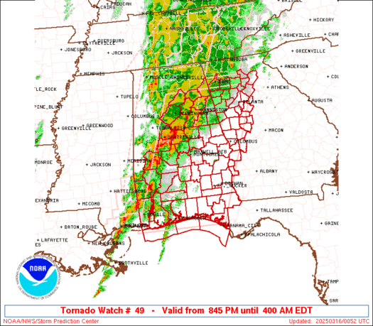
 URGENT - IMMEDIATE BROADCAST REQUESTED
Tornado Watch Number 49
NWS Storm Prediction Center Norman OK
845 PM EDT Sat Mar 15 2025 The NWS Storm Prediction Center has issued a * Tornado Watch for portions of Eastern and Southern Alabama Western Florida Panhandle Western and Central Georgia Coastal Waters * Effective this Saturday night and Sunday morning from 845 PM until 400 AM EDT. * Primary threats include... Several tornadoes and a couple intense tornadoes likely Scattered large hail and isolated very large hail events to 2 inches in diameter likely Scattered damaging wind gusts to 70 mph likely SUMMARY...Severe thunderstorms will move northeast across the watch
area through early Sunday morning. The primary risks will be
tornadoes, a couple of which may be strong, damaging thunderstorm
winds, and large hail. The tornado watch area is approximately along and 90 statute miles
east and west of a line from 40 miles east northeast of Gadsden AL
to 25 miles south southeast of Pensacola FL. For a complete
depiction of the watch see the associated watch outline update
(WOUS64 KWNS WOU9). PRECAUTIONARY/PREPAREDNESS ACTIONS... REMEMBER...A Tornado Watch means conditions are favorable for
tornadoes and severe thunderstorms in and close to the watch
area. Persons in these areas should be on the lookout for
threatening weather conditions and listen for later statements
and possible warnings. && OTHER WATCH INFORMATION...CONTINUE...WW 46...WW 47...WW 48... AVIATION...Tornadoes and a few severe thunderstorms with hail
surface and aloft to 2 inches. Extreme turbulence and surface wind
gusts to 60 knots. A few cumulonimbi with maximum tops to 500. Mean
storm motion vector 23040. ...Bunting

Tornadoes have ravaged several states since Friday, decimating homes, snapping trees and leaving towns like Tylertown, Mississippi, leveled.

A family was recording video as a violent tornado ripped through Tylertown, Mississippi, on Saturday afternoon.
WW 48 TORNADO GA NC TN 152155Z – 160500Z 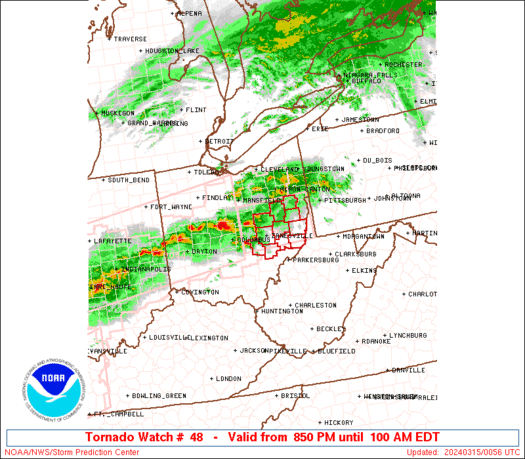
 URGENT - IMMEDIATE BROADCAST REQUESTED
Tornado Watch Number 48
NWS Storm Prediction Center Norman OK
555 PM EDT Sat Mar 15 2025 The NWS Storm Prediction Center has issued a * Tornado Watch for portions of Northwest Georgia Far Western North Carolina Eastern Tennessee * Effective this Saturday afternoon and Sunday morning from 555 PM until 100 AM EDT. * Primary threats include... A few tornadoes likely with a couple intense tornadoes possible Widespread damaging winds and isolated significant gusts to 75 mph likely Scattered large hail and isolated very large hail events to 2 inches in diameter possible SUMMARY...Severe thunderstorms will move northeast across the watch
area through this evening, with a risk for tornadoes, a couple
potentially strong, damaging wind gusts and large hail. The tornado watch area is approximately along and 35 statute miles
east and west of a line from 50 miles north of Knoxville TN to 40
miles south southeast of Chattanooga TN. For a complete depiction of
the watch see the associated watch outline update (WOUS64 KWNS
WOU8). PRECAUTIONARY/PREPAREDNESS ACTIONS... REMEMBER...A Tornado Watch means conditions are favorable for
tornadoes and severe thunderstorms in and close to the watch
area. Persons in these areas should be on the lookout for
threatening weather conditions and listen for later statements
and possible warnings. && OTHER WATCH INFORMATION...CONTINUE...WW 45...WW 46...WW 47... AVIATION...Tornadoes and a few severe thunderstorms with hail
surface and aloft to 2 inches. Extreme turbulence and surface wind
gusts to 65 knots. A few cumulonimbi with maximum tops to 450. Mean
storm motion vector 25040. ...Bunting

An earthquake rattled parts of central Mississippi on Saturday as the state endured an outbreak of tornadoes.

Tornadoes wreaked havoc across the nationâs heartland late Friday night, including parts of the St. Louis area. Video from the airport shows an airplane taking off as the area was under a Tornado Warning.