Watch: Tornado lashes truck as men ride out storm at Rolla, Missouri gas station

Strong storms erupted in the Midwest on Friday evening, including a likely tornado that hit Rolla, Missouri.
24/7 Tornado Newsfeed
Strong storms erupted in the Midwest on Friday evening, including a likely tornado that hit Rolla, Missouri.
WW 39 SEVERE TSTM WI 150305Z – 150900Z 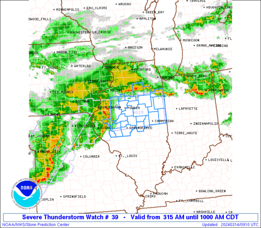
 URGENT - IMMEDIATE BROADCAST REQUESTED
Severe Thunderstorm Watch Number 39
NWS Storm Prediction Center Norman OK
1005 PM CDT Fri Mar 14 2025 The NWS Storm Prediction Center has issued a * Severe Thunderstorm Watch for portions of Southern Wisconsin * Effective this Friday night and Saturday morning from 1005 PM until 400 AM CDT. * Primary threats include... Scattered damaging wind gusts to 70 mph possible Isolated large hail events to 1.5 inches in diameter possible SUMMARY...Potential for damaging wind gusts is expected to continue
tonight across southern Wisconsin. The severe thunderstorm watch area is approximately along and 40
statute miles north and south of a line from 35 miles west southwest
of Madison WI to 50 miles east northeast of Janesville WI. For a
complete depiction of the watch see the associated watch outline
update (WOUS64 KWNS WOU9). PRECAUTIONARY/PREPAREDNESS ACTIONS... REMEMBER...A Severe Thunderstorm Watch means conditions are
favorable for severe thunderstorms in and close to the watch area.
Persons in these areas should be on the lookout for threatening
weather conditions and listen for later statements and possible
warnings. Severe thunderstorms can and occasionally do produce
tornadoes. && OTHER WATCH INFORMATION...CONTINUE...WW 32...WW 33...WW 34...WW
35...WW 36...WW 37...WW 38... AVIATION...A few severe thunderstorms with hail surface and aloft to
1.5 inches. Extreme turbulence and surface wind gusts to 60 knots. A
few cumulonimbi with maximum tops to 500. Mean storm motion vector
24040. ...Mosier
WW 0038 Status Updates 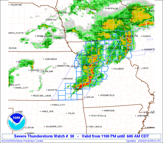
 STATUS REPORT ON WW 4 SEVERE WEATHER THREAT CONTINUES RIGHT OF A LINE FROM 20 SSW TYS
TO 15 NE TYS TO 30 NE TYS TO 35 WNW HSS TO 25 NNE TRI. WW 4 WILL BE ALLOWED TO EXPIRE AT 070500Z. ..HART..02/07/25 ATTN...WFO...JKL...MRX... STATUS REPORT FOR WS 4 SEVERE WEATHER THREAT CONTINUES FOR THE FOLLOWING AREAS TNC009-029-059-089-155-163-179-070500- TN . TENNESSEE COUNTIES INCLUDED ARE BLOUNT COCKE GREENE JEFFERSON SEVIER SULLIVAN WASHINGTON THE WATCH STATUS MESSAGE IS FOR GUIDANCE PURPOSES ONLY. PLEASE
REFER TO WATCH COUNTY NOTIFICATION STATEMENTS FOR OFFICIAL
INFORMATION ON COUNTIES...INDEPENDENT CITIES AND MARINE ZONES
CLEARED FROM SEVERE THUNDERSTORM AND TORNADO WATCHES.
WW 38 TORNADO AR LA MS 150245Z – 151000Z
 URGENT - IMMEDIATE BROADCAST REQUESTED
Tornado Watch Number 38
NWS Storm Prediction Center Norman OK
945 PM CDT Fri Mar 14 2025 The NWS Storm Prediction Center has issued a * Tornado Watch for portions of Southern Arkansas Northeast Louisiana Western Mississippi * Effective this Friday night and Saturday morning from 945 PM until 500 AM CDT. * Primary threats include... A few tornadoes likely with a couple intense tornadoes possible Scattered large hail and isolated very large hail events to 2.5 inches in diameter possible Scattered damaging wind gusts to 70 mph possible SUMMARY...The moist, unstable, and moderately to strongly sheared
airmass that exists over the region will remain supportive of
thunderstorms capable of all severe hazards, including a strong
(EF2+) tornado, for the next several hours. The tornado watch area is approximately along and 75 statute miles
east and west of a line from 75 miles southeast of Monroe LA to 35
miles north northwest of Monticello AR. For a complete depiction of
the watch see the associated watch outline update (WOUS64 KWNS
WOU8). PRECAUTIONARY/PREPAREDNESS ACTIONS... REMEMBER...A Tornado Watch means conditions are favorable for
tornadoes and severe thunderstorms in and close to the watch
area. Persons in these areas should be on the lookout for
threatening weather conditions and listen for later statements
and possible warnings. && OTHER WATCH INFORMATION...CONTINUE...WW 32...WW 33...WW 34...WW
35...WW 36...WW 37... AVIATION...Tornadoes and a few severe thunderstorms with hail
surface and aloft to 2.5 inches. Extreme turbulence and surface wind
gusts to 60 knots. A few cumulonimbi with maximum tops to 500. Mean
storm motion vector 24035. ...Mosier
WW 0037 Status Updates 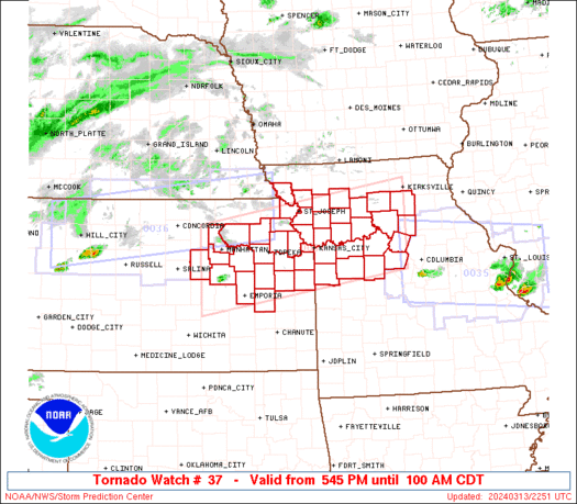
 STATUS REPORT ON WW 3 SEVERE WEATHER THREAT CONTINUES RIGHT OF A LINE FROM 45 NNW CSV
TO 10 WNW LOZ TO 50 ESE JKL TO 45 WNW BLF. FOR ADDITIONAL INFORMATION SEE MESOSCALE DISCUSSION 0069 ..DEAN..02/06/25 ATTN...WFO...LMK...JKL... STATUS REPORT FOR WT 3 SEVERE WEATHER THREAT CONTINUES FOR THE FOLLOWING AREAS KYC013-051-071-095-119-121-125-133-147-193-195-199-231-235-
061640- KY . KENTUCKY COUNTIES INCLUDED ARE BELL CLAY FLOYD HARLAN KNOTT KNOX LAUREL LETCHER MCCREARY PERRY PIKE PULASKI WAYNE WHITLEY THE WATCH STATUS MESSAGE IS FOR GUIDANCE PURPOSES ONLY. PLEASE
REFER TO WATCH COUNTY NOTIFICATION STATEMENTS FOR OFFICIAL
INFORMATION ON COUNTIES...INDEPENDENT CITIES AND MARINE ZONES
CLEARED FROM SEVERE THUNDERSTORM AND TORNADO WATCHES.
WW 37 TORNADO IL IN 150100Z – 150800Z
 URGENT - IMMEDIATE BROADCAST REQUESTED
Tornado Watch Number 37
NWS Storm Prediction Center Norman OK
800 PM CDT Fri Mar 14 2025 The NWS Storm Prediction Center has issued a * Tornado Watch for portions of Central Illinois West-Central Indiana * Effective this Friday night and Saturday morning from 800 PM until 300 AM CDT. * Primary threats include... A few tornadoes likely with a couple intense tornadoes possible Widespread damaging winds and isolated significant gusts to 80 mph likely Scattered large hail and isolated very large hail events to 2.5 inches in diameter likely SUMMARY...Ongoing storms across Missouri have intensified over the
past hour or so. These storms are expected to continue moving
northeastward into central IL and west-central IN over the next few
hours. The environment over this region will remain supportive of
severe thunderstorm capable of all severe hazards, including strong
wind gusts up to 80 mph, large hail over up to 2-2.5", and
tornadoes. Given the environmental conditions, a few strong (EF2+)
tornadoes are possible. The tornado watch area is approximately along and 75 statute miles
east and west of a line from 35 miles north of Bloomington IL to 60
miles south southeast of Mattoon IL. For a complete depiction of the
watch see the associated watch outline update (WOUS64 KWNS WOU7). PRECAUTIONARY/PREPAREDNESS ACTIONS... REMEMBER...A Tornado Watch means conditions are favorable for
tornadoes and severe thunderstorms in and close to the watch
area. Persons in these areas should be on the lookout for
threatening weather conditions and listen for later statements
and possible warnings. && OTHER WATCH INFORMATION...CONTINUE...WW 31...WW 32...WW 33...WW
34...WW 35...WW 36... AVIATION...Tornadoes and a few severe thunderstorms with hail
surface and aloft to 2.5 inches. Extreme turbulence and surface wind
gusts to 70 knots. A few cumulonimbi with maximum tops to 500. Mean
storm motion vector 24040. ...Mosier
WW 36 TORNADO AR IL IN KY MO MS TN 150030Z – 150800Z 
 URGENT - IMMEDIATE BROADCAST REQUESTED
Tornado Watch Number 36
NWS Storm Prediction Center Norman OK
730 PM CDT Fri Mar 14 2025 The NWS Storm Prediction Center has issued a * Tornado Watch for portions of Northeast Arkansas Southern Illinois Far Southwest Indiana Western Kentucky Southeast Missouri Northern Mississippi Western Tennessee * Effective this Friday night and Saturday morning from 730 PM until 300 AM CDT. ...THIS IS A PARTICULARLY DANGEROUS SITUATION... * Primary threats include... Several tornadoes and a few intense tornadoes likely Widespread damaging winds and scattered significant gusts to 80 mph likely Scattered large hail and isolated very large hail events to 2.5 inches in diameter likely SUMMARY...Severe thunderstorms are expected to develop across the
watch area over the next several hours. Environmental conditions are
very favorable for supercells capable of all severe hazards,
including very large hail (i.e. greater than 2" in diameter) and
strong (EF2+) tornadoes. If storms can remain discrete, potential
exists for a few long-track tornadoes. The tornado watch area is approximately along and 75 statute miles
east and west of a line from 40 miles west northwest of Evansville
IN to 25 miles southwest of Oxford MS. For a complete depiction of
the watch see the associated watch outline update (WOUS64 KWNS
WOU6). PRECAUTIONARY/PREPAREDNESS ACTIONS... REMEMBER...A Tornado Watch means conditions are favorable for
tornadoes and severe thunderstorms in and close to the watch
area. Persons in these areas should be on the lookout for
threatening weather conditions and listen for later statements
and possible warnings. && OTHER WATCH INFORMATION...CONTINUE...WW 31...WW 32...WW 33...WW
34...WW 35... AVIATION...Tornadoes and a few severe thunderstorms with hail
surface and aloft to 2.5 inches. Extreme turbulence and surface wind
gusts to 70 knots. A few cumulonimbi with maximum tops to 500. Mean
storm motion vector 24035. ...Mosier
