SPC – No watches are valid as of Thu Mar 13 04:02:02 UTC 2025
No watches are valid as of Thu Mar 13 04:02:02 UTC 2025.
24/7 Tornado Newsfeed
No watches are valid as of Thu Mar 13 04:02:02 UTC 2025.

NASAâs Spectro-Photometer for the History of the Universe, Epoch of Reionization, and Ices Explorer (SPHEREx) lifted off on March 11 aboard a SpaceX Falcon 9 rocket from the Vandenberg Space Force Base in California. The space agency says alongside the SPHEREx mission, four small satellites from the Polarimeter to Unify the Corona and Heliosphere mission also launched. PUNCH is slated to study the Sunâs outer atmosphere and how it contributes to solar wind.

As of 8 PM, storms are lining up near Giddings, Bryan, Crockett, Reklaw, and Henderson, moving east/southeast at 30 mph. Expect gusty winds up to 45 MPH and some pocket-change size hail! A severe storm watch is in effect until 11 PM for these areas. So far, no storms have formed north of Interstate 20 […]

The crew of NASAâs SpaceX Crew-10 mission was expected to launch from the Kennedy Space Center around 7:48 p.m. local time on Wednesday. NASA astronauts Anne McClain and Nichole Ayers, JAXA (Japan Aerospace Exploration Agency) astronaut Takuya Onishi and Roscosmos cosmonaut Kirill Peskov will replace the previous crew, including Suni Williams and Butch Wilmore. Williams and Wilmore were part of the Boeing Starliner crew, which was slated to return to Earth in June, but NASA deemed the mission too risky, and the spacecraft returned with a crew onboard.
![Texas Severe Thunderstorm Nowcast [6 PM 3/12/2025]](https://i0.wp.com/texasstormchasers.com/wp-content/uploads/2025/03/Texas-Severe-Thunderstorm-Nowcast-6-PM-3122025.jpg?w=1920&resize=1920,0&ssl=1 "Texas Severe Thunderstorm Nowcast [6 PM 3/12/2025]")
A broken line of thunderstorms extends from Malakoff to Teague, Kosse, Rosebud, and Taylor, just east of Round Rock. Currently, most storms are behaving, but small hail and gusty winds are possible. The storms are moving east at 35 miles per hour. A severe thunderstorm watch is in effect until 11 PM for Northeast Texas, […]
![Texas Severe Weather Update [4:30PM March 12, 2025]](https://i3.wp.com/texasstormchasers.com/wp-content/uploads/2025/03/Texas-Severe-Weather-Update-430PM-March-12-2025.jpg?w=1920&resize=1920,0&ssl=1 "Texas Severe Weather Update [4:30PM March 12, 2025]")
The risk of severe storms is increasing over the next several hours across eastern North Texas, the Brazos Valley, East Texas, and Northeast Texas. Activity is expected to be east of Interstate 35 shortly, which keeps the highest threat of severe storms east of the D/FW Metroplex. Our first storms of the day have developed […]

The PGA Players Championship begins this week as players from all over the association have their hearts set on the $25 million prize.
WW 29 SEVERE TSTM AR LA TX 122110Z – 130400Z 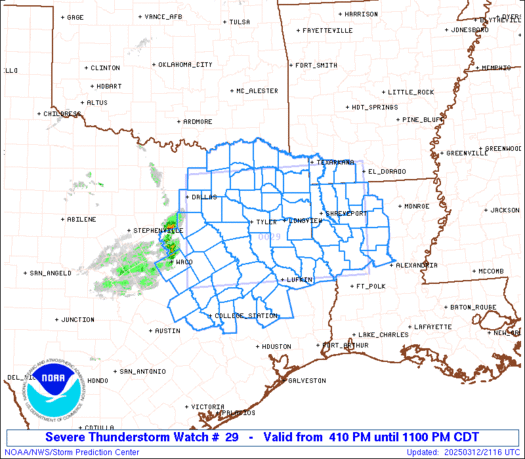
 URGENT - IMMEDIATE BROADCAST REQUESTED
Severe Thunderstorm Watch Number 29
NWS Storm Prediction Center Norman OK
410 PM CDT Wed Mar 12 2025 The NWS Storm Prediction Center has issued a * Severe Thunderstorm Watch for portions of Southwest Arkansas Northwest Louisiana North-central and Northeast Texas * Effective this Wednesday afternoon and evening from 410 PM until 1100 PM CDT. * Primary threats include... Scattered large hail likely with isolated very large hail events to 2.5 inches in diameter possible Scattered damaging wind gusts to 70 mph possible A tornado or two possible SUMMARY...Thunderstorms will continue to increase in coverage and
intensity this afternoon and early evening. Supercells should pose a
threat for large hail around 1.5-2.5 inches in diameter. A small
cluster may eventually develop and pose a threat for severe/damaging
winds of 60-70 mph through this evening. The severe thunderstorm watch area is approximately along and 75
statute miles north and south of a line from 30 miles west northwest
of Corsicana TX to 45 miles north northeast of Natchitoches LA. For
a complete depiction of the watch see the associated watch outline
update (WOUS64 KWNS WOU9). PRECAUTIONARY/PREPAREDNESS ACTIONS... REMEMBER...A Severe Thunderstorm Watch means conditions are
favorable for severe thunderstorms in and close to the watch area.
Persons in these areas should be on the lookout for threatening
weather conditions and listen for later statements and possible
warnings. Severe thunderstorms can and occasionally do produce
tornadoes. && AVIATION...A few severe thunderstorms with hail surface and aloft to
2.5 inches. Extreme turbulence and surface wind gusts to 60 knots. A
few cumulonimbi with maximum tops to 500. Mean storm motion vector
26040. ...Gleason

While thunderstorms are common, particularly in the summer, Disney World is no stranger to more extreme weather events, including hurricanes. While there is not an extensive rain policy, Disney does have an extensive hurricane policy that goes into effect.