Day: March 5, 2025
SPC Tornado Watch 26
WW 26 TORNADO NC SC CW 051245Z – 051800Z 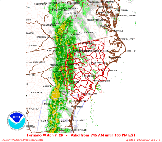
 URGENT - IMMEDIATE BROADCAST REQUESTED
Tornado Watch Number 26
NWS Storm Prediction Center Norman OK
745 AM EST Wed Mar 5 2025 The NWS Storm Prediction Center has issued a * Tornado Watch for portions of Central and Eastern North Carolina Central and Eastern South Carolina Coastal Waters * Effective this Wednesday morning and afternoon from 745 AM until 100 PM EST. * Primary threats include... A couple tornadoes possible Scattered damaging wind gusts to 70 mph likely SUMMARY...A broken squall line will continue east across the Watch
area through the midday into the early afternoon. Very strong wind
fields and a destabilizing airmass will support the potential for
embedded circulations in the squall line to pose a risk for damaging
gusts (55-70 mph) and a threat for tornadoes. The tornado watch area is approximately along and 95 statute miles
east and west of a line from 50 miles north of Raleigh NC to 10
miles south of Charleston SC. For a complete depiction of the watch
see the associated watch outline update (WOUS64 KWNS WOU6). PRECAUTIONARY/PREPAREDNESS ACTIONS... REMEMBER...A Tornado Watch means conditions are favorable for
tornadoes and severe thunderstorms in and close to the watch
area. Persons in these areas should be on the lookout for
threatening weather conditions and listen for later statements
and possible warnings. && OTHER WATCH INFORMATION...CONTINUE...WW 25... AVIATION...Tornadoes and a few severe thunderstorms with hail
surface and aloft to 0.5 inches. Extreme turbulence and surface wind
gusts to 60 knots. A few cumulonimbi with maximum tops to 300. Mean
storm motion vector 24035. ...Smith
Calmer Weather Briefly Returns before Rain/Snow Chances Saturday

After a very active Tuesday regarding weather across Texas, today will be a calmer, though still breezy, day throughout the state. Improved conditions will enable firefighters to enhance containment of ongoing wildfires. We expect the wildfire danger to rise again starting tomorrow in the western half of Texas, accompanied by stronger southerly winds. We do […]
The Daily Weather Update from FOX Weather: Severe storms charge East after leaving deadly destruction in South

Top weather news for Wednesday, March 5, 2025: The severe weather threat spans from New York to Florida after the same system left two dead and thousands without power in the South, while blizzard conditions are lashing the Plains and Midwest.
Air quality remains poor, winds subside this afternoon
Dusty skies will improve as the day wears on, with breezy winds returning this morning.
SPC Severe Thunderstorm Watch 25
WW 25 SEVERE TSTM FL GA SC CW 050815Z – 051500Z 
 URGENT - IMMEDIATE BROADCAST REQUESTED
Severe Thunderstorm Watch Number 25
NWS Storm Prediction Center Norman OK
315 AM EST Wed Mar 5 2025 The NWS Storm Prediction Center has issued a * Severe Thunderstorm Watch for portions of North Florida Southern into Southeast Georgia Southern South Carolina Coastal Waters * Effective this Wednesday morning from 315 AM until 1000 AM EST. * Primary threats include... Scattered damaging wind gusts to 70 mph possible A tornado or two possible SUMMARY...A squall line will move eastward across the Watch area
overnight into the morning. Damaging gusts ranging 55-70 mph are
possible with the stronger inflections and bowing segments within
the convective line. A brief tornado is also possible. The severe thunderstorm watch area is approximately along and 90
statute miles east and west of a line from 55 miles north northeast
of Vidalia GA to 55 miles south of Valdosta GA. For a complete
depiction of the watch see the associated watch outline update
(WOUS64 KWNS WOU5). PRECAUTIONARY/PREPAREDNESS ACTIONS... REMEMBER...A Severe Thunderstorm Watch means conditions are
favorable for severe thunderstorms in and close to the watch area.
Persons in these areas should be on the lookout for threatening
weather conditions and listen for later statements and possible
warnings. Severe thunderstorms can and occasionally do produce
tornadoes. && OTHER WATCH INFORMATION...CONTINUE...WW 23...WW 24... AVIATION...A few severe thunderstorms with hail surface and aloft to
0.5 inches. Extreme turbulence and surface wind gusts to 60 knots. A
few cumulonimbi with maximum tops to 350. Mean storm motion vector
26035. ...Smith