SPC – No watches are valid as of Mon Jan 6 04:48:02 UTC 2025
No watches are valid as of Mon Jan 6 04:48:02 UTC 2025.
24/7 Tornado Newsfeed
No watches are valid as of Mon Jan 6 04:48:02 UTC 2025.
While we don’t often share winter weather forecasts far ahead of time, we’re starting to feel more optimistic about a potential winter storm that could kick off Wednesday evening in the west and carry through Thursday, wrapping up by Friday morning in the east. We may see some notable snow accumulations and a bit of […]
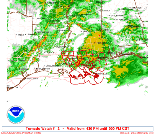
WW 2 TORNADO AR LA MS 051935Z – 060300Z 
 URGENT - IMMEDIATE BROADCAST REQUESTED
Tornado Watch Number 2
NWS Storm Prediction Center Norman OK
135 PM CST Sun Jan 5 2025 The NWS Storm Prediction Center has issued a * Tornado Watch for portions of Far Eastern Arkansas Eastern and Southeast Louisiana Southwest into Central and Northern Mississippi * Effective this Sunday afternoon and evening from 135 PM until 900 PM CST. * Primary threats include... A few tornadoes likely with a couple intense tornadoes possible Scattered damaging winds likely with isolated significant gusts to 75 mph possible Isolated large hail events to 1.5 inches in diameter possible SUMMARY...Isolated to scattered thunderstorms will likely continue
to develop ahead a squall line this afternoon and evening. The more
intense storms will likely be supercellular and pose a risk for
tornadoes, a couple of which may be strong. Scattered damaging
gusts and a risk for a tornado will also accompany the squall line
as it pushes east across the Watch area this afternoon through the
evening. The tornado watch area is approximately along and 75 statute miles
east and west of a line from 5 miles east northeast of Oxford MS to
75 miles south southeast of Alexandria LA. For a complete depiction
of the watch see the associated watch outline update (WOUS64 KWNS
WOU2). PRECAUTIONARY/PREPAREDNESS ACTIONS... REMEMBER...A Tornado Watch means conditions are favorable for
tornadoes and severe thunderstorms in and close to the watch
area. Persons in these areas should be on the lookout for
threatening weather conditions and listen for later statements
and possible warnings. && OTHER WATCH INFORMATION...CONTINUE...WW 1... AVIATION...Tornadoes and a few severe thunderstorms with hail
surface and aloft to 1.5 inches. Extreme turbulence and surface wind
gusts to 65 knots. A few cumulonimbi with maximum tops to 450. Mean
storm motion vector 24040. ...Smith
An avalanche closed a Utah highway outside of Salt Lake City during a winter storm over the weekend that brought nearly 2 feet of snow to some areas.
A powerful winter storm moving across the Midwest and Plains is producing snow and ice, causing dangerous travel conditions, and is expected to impact millions more as it moves across the country toward the East Coast.
Crashy the cold front is roaring south into Texas today with strong north winds and plummeting temperatures. We expect cold, January-like weather to stick around through the next five days across Texas. Severe storms with damaging winds and a couple of tornadoes are possible through mid-afternoon in the Ark-La-Tex, East Texas, Southeast Texas, and the […]
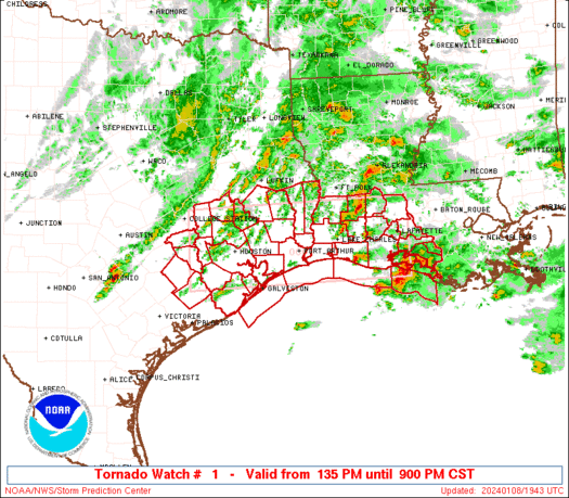
WW 1 TORNADO AR LA TX 051625Z – 060000Z 
 URGENT - IMMEDIATE BROADCAST REQUESTED
Tornado Watch Number 1
NWS Storm Prediction Center Norman OK
1025 AM CST Sun Jan 5 2025 The NWS Storm Prediction Center has issued a * Tornado Watch for portions of Southern Arkansas Western and Northern Louisiana East and Southeast Texas * Effective this Sunday morning and evening from 1025 AM until 600 PM CST. * Primary threats include... A few tornadoes likely with a couple intense tornadoes possible Scattered damaging winds likely with isolated significant gusts to 75 mph possible Isolated large hail events to 1.5 inches in diameter possible SUMMARY...Thunderstorms are forecast to intensify and increase in
coverage across the Watch area. A few semi-discrete storms are
expected to develop ahead of the main band of storms. The storms
developing ahead of the thunderstorm line will pose a risk for a few
tornadoes, including the possibility for a couple of strong
tornadoes. Damaging gusts will also be possible with the more
intense portions of a squall line expected to develop and move east
across the Watch area. The tornado watch area is approximately along and 80 statute miles
east and west of a line from 45 miles northwest of Monticello AR to
70 miles east southeast of Huntsville TX. For a complete depiction
of the watch see the associated watch outline update (WOUS64 KWNS
WOU1). PRECAUTIONARY/PREPAREDNESS ACTIONS... REMEMBER...A Tornado Watch means conditions are favorable for
tornadoes and severe thunderstorms in and close to the watch
area. Persons in these areas should be on the lookout for
threatening weather conditions and listen for later statements
and possible warnings. && AVIATION...Tornadoes and a few severe thunderstorms with hail
surface and aloft to 1.5 inches. Extreme turbulence and surface wind
gusts to 65 knots. A few cumulonimbi with maximum tops to 450. Mean
storm motion vector 23040. ...Smith
Severe #weather and #tornado coverage for #Texas – Jan 5, 2025 Join this channel to get access to perks: https://www.youtube.com/channel/UCoIfgmxArIATc2EpHD3W9EA/join LIVE TEXAS WEATHER COVERAGE brought to you by David Reimer and the @texasstormchasers Special Thanks to Comly Sport Horses! https://www.happycomlysporthorses.com/ Check out our current LIVE STREAM: https://texasweather.video/ Our FREE WEATHER APP: https://texasweather.app/ Our WEBSITE/RADAR: https://www.texasstormchasers.com […]