Severe weather shifts to Northeast midweek with damaging wind threats along I-95 corridor
A severe weather threat shifts to the Northeast on Tuesday where strong storms could cause damaging winds and flooding.
24/7 Tornado Newsfeed
A severe weather threat shifts to the Northeast on Tuesday where strong storms could cause damaging winds and flooding.
Unlike the previous two summers of intense heat, it looks like weâll get a welcome relief later this week into the weekend. A rather pleasant weather pattern change is going to bring cooler weather (for July, come on now) and higher rain chances to Texas. This doesnât look to be a short-duration event, either. We […]
A deadly and destructive derecho blasted across the Midwest on Monday packing hurricane-force wind gusts and likely tornadoes that caused extensive damage to communities along a 480-mile-long path extending from Iowa to Indiana.
Temperatures, like yesterday, will soar to near 100 this afternoon. A weak front and a pattern change will bring rain back into the picture by Thursday.
WW 544 SEVERE TSTM KS 160900Z – 161400Z 
 URGENT - IMMEDIATE BROADCAST REQUESTED
Severe Thunderstorm Watch Number 544
NWS Storm Prediction Center Norman OK
400 AM CDT Tue Jul 16 2024 The NWS Storm Prediction Center has issued a * Severe Thunderstorm Watch for portions of North-central and northeastern Kansas * Effective this Tuesday morning from 400 AM until 900 AM CDT. * Primary threats include... Isolated significant damaging wind gusts to 75 mph possible Isolated very large hail events to 2 inches in diameter possible SUMMARY...A small but severe and growing complex of thunderstorms,
initially straddling the I-70 corridor near RSL, has produced
measured severe gusts at HYS and RSL, and may continue to offer
occasional severe wind as it moves generally eastward to
east-northeastward near an instability axis. The severe thunderstorm watch area is approximately along and 40
statute miles either side of a line from 60 miles west northwest of
Salina KS to 35 miles east northeast of Manhattan KS. For a complete
depiction of the watch see the associated watch outline update
(WOUS64 KWNS WOU4). PRECAUTIONARY/PREPAREDNESS ACTIONS... REMEMBER...A Severe Thunderstorm Watch means conditions are
favorable for severe thunderstorms in and close to the watch area.
Persons in these areas should be on the lookout for threatening
weather conditions and listen for later statements and possible
warnings. Severe thunderstorms can and occasionally do produce
tornadoes. && AVIATION...A few severe thunderstorms with hail surface and aloft to
2 inches. Extreme turbulence and surface wind gusts to 65 knots. A
few cumulonimbi with maximum tops to 550. Mean storm motion vector
26035. ...Edwards
No watches are valid as of Tue Jul 16 08:09:02 UTC 2024.
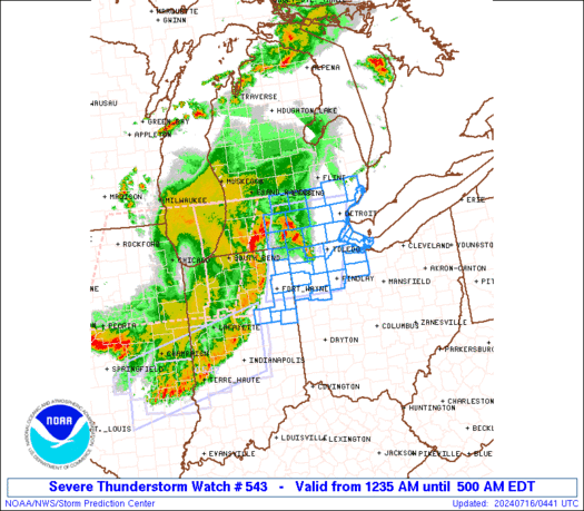
WW 543 SEVERE TSTM IN MI OH LE 160435Z – 160900Z 
 URGENT - IMMEDIATE BROADCAST REQUESTED
Severe Thunderstorm Watch Number 543
NWS Storm Prediction Center Norman OK
1235 AM EDT Tue Jul 16 2024 The NWS Storm Prediction Center has issued a * Severe Thunderstorm Watch for portions of Northeast Indiana Southeast Lower Michigan Northwest Ohio Lake Erie * Effective this Tuesday morning from 1235 AM until 500 AM EDT. * Primary threats include... Scattered damaging wind gusts to 70 mph possible Isolated large hail events to 1 inch in diameter possible A tornado or two possible SUMMARY...A long-lived bowing line of storms will tend to weaken
slowly through the early morning hours, but occasional damaging
gusts up to 60-70 mph, isolated hail up to 1 inch in diameter and a
tornado or two with embedded circulations will remain possible in
the interim. The severe thunderstorm watch area is approximately along and 50
statute miles east and west of a line from 30 miles northeast of
Jackson MI to 35 miles east southeast of Fort Wayne IN. For a
complete depiction of the watch see the associated watch outline
update (WOUS64 KWNS WOU3). PRECAUTIONARY/PREPAREDNESS ACTIONS... REMEMBER...A Severe Thunderstorm Watch means conditions are
favorable for severe thunderstorms in and close to the watch area.
Persons in these areas should be on the lookout for threatening
weather conditions and listen for later statements and possible
warnings. Severe thunderstorms can and occasionally do produce
tornadoes. && OTHER WATCH INFORMATION...CONTINUE...WW 541...WW 542... AVIATION...A few severe thunderstorms with hail surface and aloft to
1 inch. Extreme turbulence and surface wind gusts to 60 knots. A few
cumulonimbi with maximum tops to 500. Mean storm motion vector
27040. ...Thompson