Day: July 29, 2024
SPC Severe Thunderstorm Watch 561
WW 561 SEVERE TSTM ND NE SD 292125Z – 300500Z 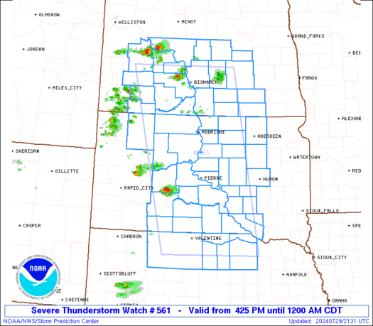
 URGENT - IMMEDIATE BROADCAST REQUESTED
Severe Thunderstorm Watch Number 561
NWS Storm Prediction Center Norman OK
425 PM CDT Mon Jul 29 2024 The NWS Storm Prediction Center has issued a * Severe Thunderstorm Watch for portions of Central North Dakota Northern Nebraska Central South Dakota * Effective this Monday afternoon from 425 PM until Midnight CDT. * Primary threats include... Scattered damaging winds and isolated significant gusts to 75 mph likely Scattered large hail and isolated very large hail events to 2 inches in diameter likely SUMMARY...Thunderstorms will develop and intensify across the watch
area through the late afternoon and evening hours, with initial
cells capable of large hail and locally damaging winds. The
potential exists for more widespread wind damage potential by mid
evening as storm clusters organize. The severe thunderstorm watch area is approximately along and 85
statute miles east and west of a line from 30 miles north northwest
of Bismarck ND to 10 miles south southeast of Ainsworth NE. For a
complete depiction of the watch see the associated watch outline
update (WOUS64 KWNS WOU1). PRECAUTIONARY/PREPAREDNESS ACTIONS... REMEMBER...A Severe Thunderstorm Watch means conditions are
favorable for severe thunderstorms in and close to the watch area.
Persons in these areas should be on the lookout for threatening
weather conditions and listen for later statements and possible
warnings. Severe thunderstorms can and occasionally do produce
tornadoes. && AVIATION...A few severe thunderstorms with hail surface and aloft to
2 inches. Extreme turbulence and surface wind gusts to 65 knots. A
few cumulonimbi with maximum tops to 500. Mean storm motion vector
28030. ...Hart
Double meteor shower peaks to end summer skygazing season

If you didnât have any luck spotting a shooting star this summer, this week might be your last chance of the skygazing season with three ongoing meteor showers, including a double meteor shower peak.
Strong geomagnetic storm could produce Northern Lights displays across northern US this week

Another Northern Lights show could be coming to parts of the northern U.S. and Midwest this week after the Sun released multiple rounds of energized particles now racing toward Earth.
Bryan Norcross: Watching for possible tropical development that could impact Florida or the Southeast

The National Hurricane Center has the odds at 50% that at least a tropical depression will develop somewhere in a large zone from near Puerto Rico across the Bahamas and curving north, including both sides of the Florida Peninsula.
Odds increase for tropical depression or storm to form and track toward Florida, Southeast US this week

A tropical disturbance is being tracked in the Atlantic Ocean for the first time since Hurricane Beryl's assault on Texas three weeks ago.
Tennessee’s Dollywood hit by flash flooding leaving 1 injured on Sunday

One person was injured at Tennessee's famous Dollywood amusement park on Sunday after a powerful thunderstorm moved across the area and produced torrential rain that caused flash flooding.
The Daily Weather Update from FOX Weather: Tropical depression could form this week with eyes on Florida
Start your day with the latest weather news: All eyes are on the Atlantic, where forecasters are watching for the possibility of tropical formation. Plus, the historic Park Fire continues to threaten Northern California.
Rain comes to an end. Next up: Saharan dust
After a few showers this morning, we’ll head into a drier, hotter pattern. We’ll also see hazy skies, as a plume of Saharan dust heads in our direction.