WW 545 SEVERE TSTM KS MO 161210Z – 161800Z
URGENT - IMMEDIATE BROADCAST REQUESTED
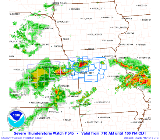
Severe Thunderstorm Watch Number 545
NWS Storm Prediction Center Norman OK
710 AM CDT Tue Jul 16 2024 The NWS Storm Prediction Center has issued a * Severe Thunderstorm Watch for portions of Extreme northeastern Kansas Northwestern and north-central Missouri * Effective this Tuesday morning and afternoon from 710 AM until 100 PM CDT. * Primary threats include... Scattered damaging winds and isolated significant gusts to 75 mph possible Isolated very large hail events to 2 inches in diameter possible SUMMARY...Clusters of strong-severe thunderstorms are expected to
move across the watch area through the remainder of the morning and
into midday, with severe gusts and isolated large hail as the
threats. The severe thunderstorm watch area is approximately along and 45
statute miles north and south of a line from 25 miles west northwest
of Leavenworth KS to 55 miles southeast of Chillicothe MO. For a
complete depiction of the watch see the associated watch outline
update (WOUS64 KWNS WOU5). PRECAUTIONARY/PREPAREDNESS ACTIONS... REMEMBER...A Severe Thunderstorm Watch means conditions are
favorable for severe thunderstorms in and close to the watch area.
Persons in these areas should be on the lookout for threatening
weather conditions and listen for later statements and possible
warnings. Severe thunderstorms can and occasionally do produce
tornadoes. && OTHER WATCH INFORMATION...CONTINUE...WW 544... AVIATION...A few severe thunderstorms with hail surface and aloft to
2 inches. Extreme turbulence and surface wind gusts to 65 knots. A
few cumulonimbi with maximum tops to 550. Mean storm motion vector
27035. ...Edwards
Read more


