Severe winds, hail forecast to strike I-95 corridor including Boston, NYC, Philadelphia

Thunderstorms will likely erupt across the Northeast later Friday as a strong cold front plows through the region.
24/7 Tornado Newsfeed
Thunderstorms will likely erupt across the Northeast later Friday as a strong cold front plows through the region.

It may not officially be summer, but that doesn’t change the fact it might as well be. Summer weather will continue across Texas over the next seven days. We’ll have isolated to scattered storms in the western third of Texas daily through the weekend during the afternoon and evening hours. Stronger storms may produce damaging […]

Start your day with the latest weather news. The dayslong streak of heavy rain in Florida continues Friday, but the risk of flooding is beginning to lower. Meanwhile, attention is turning to the tropics, where forecasters are monitoring two systems.
No watches are valid as of Fri Jun 14 06:02:02 UTC 2024.

As an atmospheric river reduces its grasp over Sunshine State, a more common weather pattern will evolve, leading to daily chances of showers and thunderstorms. Due to the heavy rainfall, the threshold for how much rain is needed to create additional flooding is lower.
WW 412 SEVERE TSTM IL MO 140110Z – 140600Z 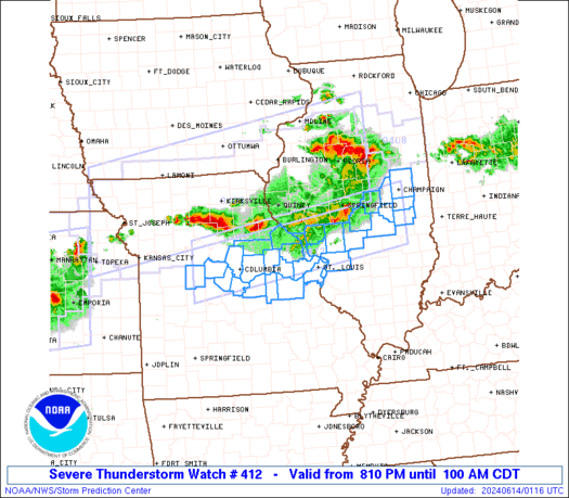
 URGENT - IMMEDIATE BROADCAST REQUESTED
Severe Thunderstorm Watch Number 412
NWS Storm Prediction Center Norman OK
810 PM CDT Thu Jun 13 2024 The NWS Storm Prediction Center has issued a * Severe Thunderstorm Watch for portions of Central Illinois Central and Eastern Missouri * Effective this Thursday night and Friday morning from 810 PM until 100 AM CDT. * Primary threats include... Scattered damaging winds likely with isolated significant gusts to 75 mph possible Scattered large hail and isolated very large hail events to 2 inches in diameter possible SUMMARY...A broken linear cluster of thunderstorms will gradually
move into the Watch area this evening. Some of the more intense
thunderstorms will be capable of a risk for large to very large hail
(1-2 inches in diameter) and severe gusts (60-75 mph). The severe
risk may linger into portions of central and east-central Missouri
into the early overnight hours. The severe thunderstorm watch area is approximately along and 40
statute miles north and south of a line from 60 miles west of
Columbia MO to 10 miles north northeast of Mattoon IL. For a
complete depiction of the watch see the associated watch outline
update (WOUS64 KWNS WOU2). PRECAUTIONARY/PREPAREDNESS ACTIONS... REMEMBER...A Severe Thunderstorm Watch means conditions are
favorable for severe thunderstorms in and close to the watch area.
Persons in these areas should be on the lookout for threatening
weather conditions and listen for later statements and possible
warnings. Severe thunderstorms can and occasionally do produce
tornadoes. && OTHER WATCH INFORMATION...CONTINUE...WW 409...WW 410...WW 411... AVIATION...A few severe thunderstorms with hail surface and aloft to
2 inches. Extreme turbulence and surface wind gusts to 65 knots. A
few cumulonimbi with maximum tops to 600. Mean storm motion vector
31025. ...Smith

For over 70 years, the Federal Flag Code has stated the ideal ways to display Old Glory.

The Sun has been active as of late as the giant star is in a period of peak activity known as the solar maximum. In addition to historic auroras seen from Earth, rovers and orbiters on Mars have captured imagery of solar flares and coronal mass ejections.
