Month: June 2024
SPC Severe Thunderstorm Watch 386
WW 386 SEVERE TSTM OK TX 032145Z – 040400Z 
 URGENT - IMMEDIATE BROADCAST REQUESTED
Severe Thunderstorm Watch Number 386
NWS Storm Prediction Center Norman OK
445 PM CDT Mon Jun 3 2024 The NWS Storm Prediction Center has issued a * Severe Thunderstorm Watch for portions of Western Oklahoma Northwest Texas and the Eastern Panhandle * Effective this Monday afternoon and evening from 445 PM until 1100 PM CDT. * Primary threats include... Scattered large hail and isolated very large hail events to 3 inches in diameter likely Scattered damaging wind gusts to 70 mph likely A tornado or two possible SUMMARY...Isolated intense supercell thunderstorms are expected to
develop this afternoon, capable of very large hail and damaging wind
gusts. An tornado or two is also possible. The severe thunderstorm watch area is approximately along and 35
statute miles east and west of a line from 140 miles north northwest
of Altus OK to 85 miles south of Altus OK. For a complete depiction
of the watch see the associated watch outline update (WOUS64 KWNS
WOU6). PRECAUTIONARY/PREPAREDNESS ACTIONS... REMEMBER...A Severe Thunderstorm Watch means conditions are
favorable for severe thunderstorms in and close to the watch area.
Persons in these areas should be on the lookout for threatening
weather conditions and listen for later statements and possible
warnings. Severe thunderstorms can and occasionally do produce
tornadoes. && OTHER WATCH INFORMATION...CONTINUE...WW 385... AVIATION...A few severe thunderstorms with hail surface and aloft to
3 inches. Extreme turbulence and surface wind gusts to 60 knots. A
few cumulonimbi with maximum tops to 500. Mean storm motion vector
29025. ...Hart
Here’s where Americans are headed for summer vacation in 2024

Where are you headed for summer vacation? It depends on where you live and how old you are, research revealed.
Japanese billionaire cancels SpaceX Starship flight around Moon, dashing dreams for selected crew

The hopes of eight artists and creators to orbit the Moon in a SpaceX Starship ended this week after the Japanese billionaire who selected them to fly on the private lunar mission canceled the flight.
Heat index as high as 105° to 110° this week in San Antonio, Texas Hill Country
Feeling much hotter than average to start June
SPC Severe Thunderstorm Watch 385
WW 385 SEVERE TSTM AR LA OK TX 031835Z – 040100Z 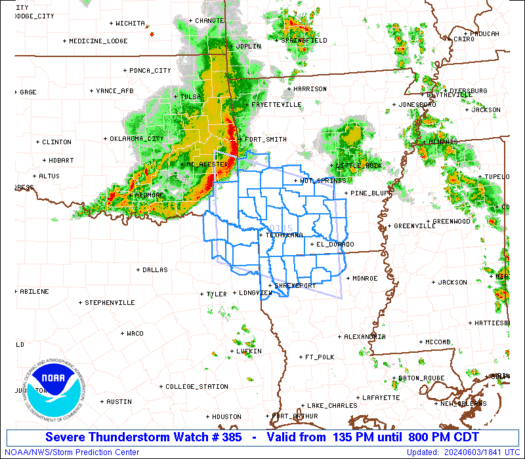
 URGENT - IMMEDIATE BROADCAST REQUESTED
Severe Thunderstorm Watch Number 385
NWS Storm Prediction Center Norman OK
135 PM CDT Mon Jun 3 2024 The NWS Storm Prediction Center has issued a * Severe Thunderstorm Watch for portions of Southwest and Southern Arkansas Northern Louisiana Far Southeast Oklahoma Far Northeast Texas * Effective this Monday afternoon and evening from 135 PM until 800 PM CDT. * Primary threats include... Scattered large hail and isolated very large hail events to 2 inches in diameter possible Scattered damaging wind gusts to 70 mph possible SUMMARY...A squall line will likely continue east-southeast across
the Watch area through the afternoon into the early evening. Strong
to severe gusts (50-70 mph) will be capable of wind damage with the
more intense downdrafts. The severe thunderstorm watch area is approximately along and 75
statute miles north and south of a line from 35 miles west of De
Queen AR to 35 miles east of El Dorado AR. For a complete depiction
of the watch see the associated watch outline update (WOUS64 KWNS
WOU5). PRECAUTIONARY/PREPAREDNESS ACTIONS... REMEMBER...A Severe Thunderstorm Watch means conditions are
favorable for severe thunderstorms in and close to the watch area.
Persons in these areas should be on the lookout for threatening
weather conditions and listen for later statements and possible
warnings. Severe thunderstorms can and occasionally do produce
tornadoes. && AVIATION...A few severe thunderstorms with hail surface and aloft to
2 inches. Extreme turbulence and surface wind gusts to 60 knots. A
few cumulonimbi with maximum tops to 500. Mean storm motion vector
29025. ...Smith
Watch as Coast Guard plucks missing diver from ocean 75 miles off South Carolina coast

The U.S. Coast Guard released a dramatic video showing the rescue of a missing man who drifted away from his vessel while diving about 75 miles off the coast of Myrtle Beach, South Carolina, on Friday.
Amazing video: Octopus changes color as it emerges from rock, scrambles toward ocean

Three coastal crawlers were recently treated to an amazing sight: An octopus crawled out from under a rock and changed color as it scampered toward the ocean.
Boeing, NASA target Wednesday for third launch attempt of NASA astronauts

The third launch attempt of Boeing's Starliner spacecraft with two NASA astronauts to the International Space Station is scheduled for Wednesday morning.