Scorching triple-digit heat escalates to life-threatening situation for 20 million in West
The first major heat wave of the season is about to sweep across the West, and temperatures are expected to climb dangerously high starting on Tuesday.
24/7 Tornado Newsfeed
The first major heat wave of the season is about to sweep across the West, and temperatures are expected to climb dangerously high starting on Tuesday.
Thunderstorms will move south across Northeast Texas and East Texas this morning into the early afternoon hours. After a brief hiatus, another round of thunderstorms is possible tonight into Wednesday morning across North Texas, Texoma, and Northeast Texas as storms move south of Oklahoma. We may also see isolated storms in the Texas Panhandle […]
No watches are valid as of Tue Jun 4 10:02:02 UTC 2024.
Start your day with the latest weather news. Weâre only four days into meteorological summer and a possible record-setting triple-digit heat wave is already impacting the West.
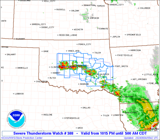
WW 388 SEVERE TSTM OK 040315Z – 041000Z 
 URGENT - IMMEDIATE BROADCAST REQUESTED
Severe Thunderstorm Watch Number 388
NWS Storm Prediction Center Norman OK
1015 PM CDT Mon Jun 3 2024 The NWS Storm Prediction Center has issued a * Severe Thunderstorm Watch for portions of Central and Eastern Oklahoma * Effective this Monday night and Tuesday morning from 1015 PM until 500 AM CDT. * Primary threats include... Scattered large hail likely with isolated very large hail events to 2.5 inches in diameter possible Scattered damaging wind gusts to 70 mph possible SUMMARY...Scattered thunderstorms are expected to form and track
across the watch area through the overnight hours. Large hail is
the primary threat, although damaging winds may also become a
concern later tonight. The severe thunderstorm watch area is approximately along and 45
statute miles north and south of a line from 45 miles northwest of
Chickasha OK to 65 miles east of Mcalester OK. For a complete
depiction of the watch see the associated watch outline update
(WOUS64 KWNS WOU8). PRECAUTIONARY/PREPAREDNESS ACTIONS... REMEMBER...A Severe Thunderstorm Watch means conditions are
favorable for severe thunderstorms in and close to the watch area.
Persons in these areas should be on the lookout for threatening
weather conditions and listen for later statements and possible
warnings. Severe thunderstorms can and occasionally do produce
tornadoes. && OTHER WATCH INFORMATION...CONTINUE...WW 387... AVIATION...A few severe thunderstorms with hail surface and aloft to
2.5 inches. Extreme turbulence and surface wind gusts to 60 knots. A
few cumulonimbi with maximum tops to 500. Mean storm motion vector
27030. ...Hart
June 3, 2024, JASON COOLEY #storm #severe #weather #sky #hail #twister #wind #rain #flood #IRL #LIVE #Txwx #texas
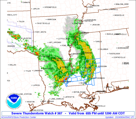
WW 387 SEVERE TSTM AR LA MS 032355Z – 040500Z 
 URGENT - IMMEDIATE BROADCAST REQUESTED
Severe Thunderstorm Watch Number 387
NWS Storm Prediction Center Norman OK
655 PM CDT Mon Jun 3 2024 The NWS Storm Prediction Center has issued a * Severe Thunderstorm Watch for portions of Southeast Arkansas Northeast Louisiana Western Mississippi * Effective this Monday night from 655 PM until Midnight CDT. * Primary threats include... Scattered damaging wind gusts to 70 mph likely Scattered large hail and isolated very large hail events to 2 inches in diameter possible SUMMARY...A line of thunderstorms will spread eastward through the
evening, posing a risk of locally damaging wind gusts across the
watch area. The severe thunderstorm watch area is approximately along and 40
statute miles east and west of a line from 100 miles north northeast
of Greenville MS to 25 miles west southwest of Natchez MS. For a
complete depiction of the watch see the associated watch outline
update (WOUS64 KWNS WOU7). PRECAUTIONARY/PREPAREDNESS ACTIONS... REMEMBER...A Severe Thunderstorm Watch means conditions are
favorable for severe thunderstorms in and close to the watch area.
Persons in these areas should be on the lookout for threatening
weather conditions and listen for later statements and possible
warnings. Severe thunderstorms can and occasionally do produce
tornadoes. && OTHER WATCH INFORMATION...CONTINUE...WW 385...WW 386... AVIATION...A few severe thunderstorms with hail surface and aloft to
2 inches. Extreme turbulence and surface wind gusts to 60 knots. A
few cumulonimbi with maximum tops to 500. Mean storm motion vector
27030. ...Hart
Major coastal cities like New Orleans are preparing for this hurricane season and future storms to come.