‘Monster’-sized hailstone could shatter Texas record, near world record

A hailstone that looks to measure about 7 inches across — longer than a can of a popular energy drink — could shatter the Texas state record for hailstone size.
24/7 Tornado Newsfeed
A hailstone that looks to measure about 7 inches across — longer than a can of a popular energy drink — could shatter the Texas state record for hailstone size.

The Storm Prediction Center issued a Severe Thunderstorm Watch for communities in New Jersey, Pennsylvania, Delaware, Maryland and Virginia on Thursday afternoon. Meteorologists said the worst storms were capable of producing wind damage.
Hail stone, potentially 7.25″ in diameter, may surpass Hondo’s 2021 massive, record-setting stone
WW 394 SEVERE TSTM DC DE MD NJ PA VA CW 061820Z – 070100Z 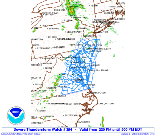
 URGENT - IMMEDIATE BROADCAST REQUESTED
Severe Thunderstorm Watch Number 394
NWS Storm Prediction Center Norman OK
220 PM EDT Thu Jun 6 2024 The NWS Storm Prediction Center has issued a * Severe Thunderstorm Watch for portions of District Of Columbia Delaware Central and Eastern Maryland Southern half of New Jersey Southeast Pennsylvania Eastern and Southern Virginia Coastal Waters * Effective this Thursday afternoon and evening from 220 PM until 900 PM EDT. * Primary threats include... Scattered damaging wind gusts to 65 mph possible SUMMARY...Scattered thunderstorms will likely continue to develop
through the afternoon into several broken bands of strong to severe
thunderstorms. The stronger thunderstorms will be capable of strong
to severe gusts (50-65 mph) capable of wind damage. This activity
will likely push east of the Atlantic Seaboard by mid to late
evening with the severe risk diminishing from west to east across
the Watch area. The severe thunderstorm watch area is approximately along and 65
statute miles east and west of a line from 5 miles northeast of
Trenton NJ to 35 miles east southeast of South Hill VA. For a
complete depiction of the watch see the associated watch outline
update (WOUS64 KWNS WOU4). PRECAUTIONARY/PREPAREDNESS ACTIONS... REMEMBER...A Severe Thunderstorm Watch means conditions are
favorable for severe thunderstorms in and close to the watch area.
Persons in these areas should be on the lookout for threatening
weather conditions and listen for later statements and possible
warnings. Severe thunderstorms can and occasionally do produce
tornadoes. && AVIATION...A few severe thunderstorms with hail surface and aloft to
1 inch. Extreme turbulence and surface wind gusts to 55 knots. A few
cumulonimbi with maximum tops to 400. Mean storm motion vector
27025. ...Smith

In the aftermath of the destructive storm that hit the Houston area on Tuesday, a woman is now caring for both her son and mother, who suffered severe burns and were admitted to intensive care units.

Severe storms early Thursday morning triggered a powerful tornado that damaged the central Ohio town of Frazeysburg.

NASA astronauts encountered problems with Boeing's Starliner spacecraft ahead of docking at the International Space Station on Thursday and continue to troubleshoot issues with thrusters that are delaying their arrival at the orbiting laboratory.

SpaceX achieved its most ambitious goals yet for its Starship spaceship on Thursday when the rocket's Super Heavy booster made a controlled landing in the Gulf of Mexico, and Starship landed in the Indian Ocean.

Record-breaking heat continues to bake Florida after many locations saw their hottest May on record, and now a flood threat is adding insult to injury as tropical downpours are expected to move into the Sunshine State at the start of the new workweek.