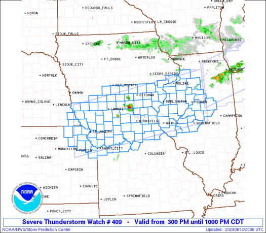
SPC Severe Thunderstorm Watch 410

WW 410 SEVERE TSTM KS 132140Z – 140400Z
WW 0410 Image

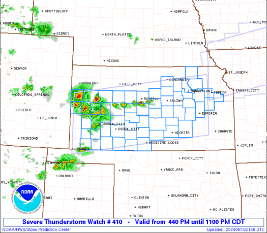
 URGENT - IMMEDIATE BROADCAST REQUESTED
Severe Thunderstorm Watch Number 410
NWS Storm Prediction Center Norman OK
440 PM CDT Thu Jun 13 2024 The NWS Storm Prediction Center has issued a * Severe Thunderstorm Watch for portions of Much of Kansas * Effective this Thursday afternoon and evening from 440 PM until 1100 PM CDT. * Primary threats include... Widespread damaging winds and isolated significant gusts to 85 mph likely Scattered large hail and isolated very large hail events to 3 inches in diameter possible SUMMARY...Scattered thunderstorms are forecast to continue to
develop late this afternoon into the early evening. Several
clusters of severe thunderstorms will likely evolve and pose a risk
for severe gusts potentially ranging between 60-85 mph. Large to
very large hail is possible with the more intense storms mainly from
central parts of Kansas eastward into eastern Kansas. The severe thunderstorm watch area is approximately along and 75
statute miles north and south of a line from 65 miles west of Garden
City KS to 30 miles northeast of Emporia KS. For a complete
depiction of the watch see the associated watch outline update
(WOUS64 KWNS WOU0). PRECAUTIONARY/PREPAREDNESS ACTIONS... REMEMBER...A Severe Thunderstorm Watch means conditions are
favorable for severe thunderstorms in and close to the watch area.
Persons in these areas should be on the lookout for threatening
weather conditions and listen for later statements and possible
warnings. Severe thunderstorms can and occasionally do produce
tornadoes. && OTHER WATCH INFORMATION...CONTINUE...WW 408...WW 409... AVIATION...A few severe thunderstorms with hail surface and aloft to
3 inches. Extreme turbulence and surface wind gusts to 75 knots. A
few cumulonimbi with maximum tops to 500. Mean storm motion vector
29025. ...Smith 

Read more

SPC Severe Thunderstorm Watch 409

WW 409 SEVERE TSTM IA IL KS MO NE 132000Z – 140300Z
WW 0409 Image

 URGENT - IMMEDIATE BROADCAST REQUESTED
Severe Thunderstorm Watch Number 409
NWS Storm Prediction Center Norman OK
300 PM CDT Thu Jun 13 2024 The NWS Storm Prediction Center has issued a * Severe Thunderstorm Watch for portions of Southern Iowa Western and Central Illinois Northeast Kansas Northern Missouri Far Southeast Nebraska * Effective this Thursday afternoon and evening from 300 PM until 1000 PM CDT. * Primary threats include... Scattered large hail and isolated very large hail events to 3 inches in diameter likely Scattered damaging winds likely with isolated significant gusts to 80 mph possible A tornado or two possible SUMMARY...Intense thunderstorms are expected to develop and pose a
threat for very large hail and significant severe/damaging winds
this afternoon and evening. Some of the hail could be 2-3 inches in
diameter, and severe winds may peak in the 70-80 mph range with any
line of thunderstorms that can form and spread east-southeastward. The severe thunderstorm watch area is approximately along and 70
statute miles north and south of a line from 20 miles south
southwest of Falls City NE to 40 miles east northeast of Peoria IL.
For a complete depiction of the watch see the associated watch
outline update (WOUS64 KWNS WOU9). PRECAUTIONARY/PREPAREDNESS ACTIONS... REMEMBER...A Severe Thunderstorm Watch means conditions are
favorable for severe thunderstorms in and close to the watch area.
Persons in these areas should be on the lookout for threatening
weather conditions and listen for later statements and possible
warnings. Severe thunderstorms can and occasionally do produce
tornadoes. && OTHER WATCH INFORMATION...CONTINUE...WW 408... AVIATION...A few severe thunderstorms with hail surface and aloft to
3 inches. Extreme turbulence and surface wind gusts to 70 knots. A
few cumulonimbi with maximum tops to 550. Mean storm motion vector
30030. ...Gleason 

Read more

SPC Severe Thunderstorm Watch 408

WW 408 SEVERE TSTM IL IN MI OH LM 131850Z – 140100Z
WW 0408 Image

 URGENT - IMMEDIATE BROADCAST REQUESTED
Severe Thunderstorm Watch Number 408
NWS Storm Prediction Center Norman OK
150 PM CDT Thu Jun 13 2024 The NWS Storm Prediction Center has issued a * Severe Thunderstorm Watch for portions of Northern Illinois Northern Indiana Southern and Central Lower Michigan Far Northwest Ohio Lake Michigan * Effective this Thursday afternoon and evening from 150 PM until 800 PM CDT. * Primary threats include... Scattered large hail and isolated very large hail events to 2.5 inches in diameter possible Scattered damaging wind gusts to 70 mph possible A tornado or two possible SUMMARY...Thunderstorms are expected to continue increasing in
coverage this afternoon while posing a threat for large hail around
1.5-2.5 inches in diameter. Severe/damaging winds of 60-70 mph may
also occur as convection moves east-southeastward and potentially
grows into one or more small clusters through the afternoon and
early evening. The severe thunderstorm watch area is approximately along and 60
statute miles north and south of a line from 20 miles west southwest
of Marseilles IL to 10 miles north of Jackson MI. For a complete
depiction of the watch see the associated watch outline update
(WOUS64 KWNS WOU8). PRECAUTIONARY/PREPAREDNESS ACTIONS... REMEMBER...A Severe Thunderstorm Watch means conditions are
favorable for severe thunderstorms in and close to the watch area.
Persons in these areas should be on the lookout for threatening
weather conditions and listen for later statements and possible
warnings. Severe thunderstorms can and occasionally do produce
tornadoes. && AVIATION...A few severe thunderstorms with hail surface and aloft to
2.5 inches. Extreme turbulence and surface wind gusts to 60 knots. A
few cumulonimbi with maximum tops to 500. Mean storm motion vector
29030. ...Gleason 

Read more