SPC Tornado Watch 189 Status Reports

SPC Tornado Watch 189 Status Reports

WW 0189 Status Updates
WW 0189 Status Image

 STATUS REPORT ON WW 189 SEVERE WEATHER THREAT CONTINUES RIGHT OF A LINE FROM 35 W SPS TO
15 SW CHK TO 10 NNW CQB TO 20 NNW TUL. ..BROYLES..05/07/24 ATTN...WFO...DDC...ICT...OUN...TSA... STATUS REPORT FOR WT 189 SEVERE WEATHER THREAT CONTINUES FOR THE FOLLOWING AREAS OKC019-027-031-033-037-049-051-067-081-087-099-107-111-123-125-
131-133-137-143-145-070640- OK . OKLAHOMA COUNTIES INCLUDED ARE CARTER CLEVELAND COMANCHE COTTON CREEK GARVIN GRADY JEFFERSON LINCOLN MCCLAIN MURRAY OKFUSKEE OKMULGEE PONTOTOC POTTAWATOMIE ROGERS SEMINOLE STEPHENS TULSA WAGONER TXC077-485-070640- TX . TEXAS COUNTIES INCLUDED ARE CLAY WICHITA THE WATCH STATUS MESSAGE IS FOR GUIDANCE PURPOSES ONLY. PLEASE
REFER TO WATCH COUNTY NOTIFICATION STATEMENTS FOR OFFICIAL

Read more

SPC Tornado Watch 190 Status Reports

SPC Tornado Watch 190 Status Reports

WW 0190 Status Updates
WW 0190 Status Image

 STATUS REPORT ON WW 190 SEVERE WEATHER THREAT CONTINUES RIGHT OF A LINE FROM 40 NE ICT TO
20 W MHK TO 30 SE BIE TO 10 WSW SDA TO 25 NE SDA. ..WENDT..05/07/24 ATTN...WFO...OAX...TOP...EAX... STATUS REPORT FOR WT 190 SEVERE WEATHER THREAT CONTINUES FOR THE FOLLOWING AREAS IAC071-137-145-070440- IA . IOWA COUNTIES INCLUDED ARE FREMONT MONTGOMERY PAGE KSC003-005-013-031-043-045-059-061-085-087-111-117-127-131-139-
149-161-177-197-070440- KS . KANSAS COUNTIES INCLUDED ARE ANDERSON ATCHISON BROWN COFFEY DONIPHAN DOUGLAS FRANKLIN GEARY JACKSON JEFFERSON LYON MARSHALL MORRIS NEMAHA OSAGE POTTAWATOMIE RILEY SHAWNEE WABAUNSEE MOC005-087-070440- 

Read more

LIVE OKLAHOMA CHASE • HIGH RISK of Tornadoes (5/6/24) {S-C-A}

LIVE OKLAHOMA CHASE • HIGH RISK of Tornadoes (5/6/24) {S-C-A}

Join this channel to get access to perks: https://www.youtube.com/channel/UCNPvoDpoOWevcdTHr8GyTyA/join Our chasers Adam and Stephen are covering today’s Slight Severe Risk threat across parts of #Texas (May 2, 2024) #IRL #Tornado #StormChasers NOT for rebroadcast or embedding. Email us at contact@texasstormchasers.com for licensing inquiries. Check out our LIVE STREAM: https://texasweather.video/ Our FREE WEATHER APP: https://texasweather.app/ Our […]

SPC Center Public Severe Weather Outlook (PWO)

SPC Center Public Severe Weather Outlook (PWO)

Public Severe Weather Outlook
PWO Image

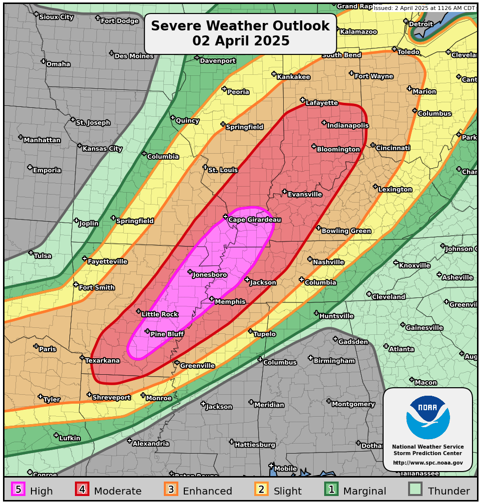
PUBLIC SEVERE WEATHER OUTLOOK NWS STORM PREDICTION CENTER NORMAN OK
0302 PM CDT MON MAY 06 2024 ...Outbreak of tornadoes and severe thunderstorms expected over
parts of the central and southern Plains this afternoon and
tonight... * LOCATIONS... Much of Oklahoma South-Central and Southeast Kansas * HAZARDS... Numerous tornadoes, several intense and long track Widespread damaging winds, some hurricane force Widespread large hail, some baseball size * SUMMARY... A regional outbreak of severe weather with multiple intense (EF3+), long-tracked tornadoes, as well as very large hail and severe thunderstorm gusts, is expected over parts of the south-central Plains from this afternoon through evening. Preparedness actions... Review your severe weather safety procedures for the possibility
of dangerous weather today. Stay tuned to NOAA Weather Radio, weather.gov, or other media for watches and warnings. A tornado
watch means that conditions are favorable for tornadoes to form
during the next several hours. If a tornado warning is issued for
your area, move to a place of safety, ideally in a basement or
interior room on the lowest floor of a sturdy building. && ..Mosier.. 05/06/2024 

Read more

SPC PDS Tornado Watch 189

SPC PDS Tornado Watch 189

WW 189 TORNADO KS OK TX 061900Z – 070400Z
WW 0189 Image

 URGENT - IMMEDIATE BROADCAST REQUESTED
Tornado Watch Number 189
NWS Storm Prediction Center Norman OK
200 PM CDT Mon May 6 2024 The NWS Storm Prediction Center has issued a * Tornado Watch for portions of Southern Kansas Western and Central Oklahoma Western North Texas * Effective this Monday afternoon and evening from 200 PM until 1100 PM CDT. ...THIS IS A PARTICULARLY DANGEROUS SITUATION... * Primary threats include... Numerous tornadoes expected with a few intense tornadoes likely Widespread large hail and scattered very large hail events to 4 inches in diameter likely Scattered damaging winds and isolated significant gusts to 75 mph likely SUMMARY...Explosive thunderstorm development is forecast this
afternoon along and east of a north to south oriented dryline. Given a very favorable environment for severe thunderstorms, intense
supercells are expected to evolve. These storms are forecast to
move east across the Watch area this afternoon through the late
evening. The possibility exists for regenerative supercell
development over central Oklahoma this evening. Initially large to
giant hail is forecast with the initial supercell activity before
the tornado risk increases. Intense tornadoes are probable
especially as the atmosphere becomes very favorable for tornadoes
late this afternoon and continuing through the evening. The tornado watch area is approximately along and 105 statute miles
east and west of a line from 25 miles north northwest of Hutchinson
KS to 50 miles south southeast of Fort Sill OK. For a complete
depiction of the watch see the associated watch outline update
(WOUS64 KWNS WOU9). PRECAUTIONARY/PREPAREDNESS ACTIONS... REMEMBER...A Tornado Watch means conditions are favorable for
tornadoes and severe thunderstorms in and close to the watch
area. Persons in these areas should be on the lookout for
threatening weather conditions and listen for later statements
and possible warnings. && OTHER WATCH INFORMATION...CONTINUE...WW 187...WW 188... AVIATION...Tornadoes and a few severe thunderstorms with hail
surface and aloft to 4 inches. Extreme turbulence and surface wind
gusts to 65 knots. A few cumulonimbi with maximum tops to 500. Mean
storm motion vector 24035. ...Smith 

Read more