Severe storms shift to Ohio Valley on Tuesday as multiday threat continues for millions across US

After Monday's deadly severe weather in the central U.S., the threat of severe storms shifts eastward into the Ohio Valley on Tuesday.
24/7 Tornado Newsfeed
After Monday's deadly severe weather in the central U.S., the threat of severe storms shifts eastward into the Ohio Valley on Tuesday.

Thankfully, a cold front will slide through on Thursday.

WW 0191 Status Updates 
 STATUS REPORT ON WW 191 SEVERE WEATHER THREAT CONTINUES RIGHT OF A LINE FROM 25 ESE LWD
TO 10 SW DSM TO 20 NW DSM TO 40 N DSM TO 30 ENE FOD. ..WENDT..05/07/24 ATTN...WFO...DMX...FSD... STATUS REPORT FOR WT 191 SEVERE WEATHER THREAT CONTINUES FOR THE FOLLOWING AREAS IAC007-051-079-099-117-123-125-127-135-153-169-179-181-185-
070740- IA . IOWA COUNTIES INCLUDED ARE APPANOOSE DAVIS HAMILTON JASPER LUCAS MAHASKA MARION MARSHALL MONROE POLK STORY WAPELLO WARREN WAYNE THE WATCH STATUS MESSAGE IS FOR GUIDANCE PURPOSES ONLY. PLEASE
REFER TO WATCH COUNTY NOTIFICATION STATEMENTS FOR OFFICIAL
INFORMATION ON COUNTIES...INDEPENDENT CITIES AND MARINE ZONES
CLEARED FROM SEVERE THUNDERSTORM AND TORNADO WATCHES.

WW 191 TORNADO IA NE SD 070030Z – 070800Z
 URGENT - IMMEDIATE BROADCAST REQUESTED
Tornado Watch Number 191
NWS Storm Prediction Center Norman OK
730 PM CDT Mon May 6 2024 The NWS Storm Prediction Center has issued a * Tornado Watch for portions of Western and Central Iowa Northeast Nebraska Far Southeast South Dakota * Effective this Monday night and Tuesday morning from 730 PM until 300 AM CDT. * Primary threats include... A couple tornadoes possible Scattered damaging winds likely with isolated significant gusts to 75 mph possible Isolated large hail events to 1.5 inches in diameter possible SUMMARY...Bands of storms will continue northeastward across the
region through the evening and early overnight, with damaging winds,
some hail, and a tornado risk. The tornado watch area is approximately along and 60 statute miles
east and west of a line from 20 miles north northwest of Storm Lake
IA to 25 miles east of Lamoni IA. For a complete depiction of the
watch see the associated watch outline update (WOUS64 KWNS WOU1). PRECAUTIONARY/PREPAREDNESS ACTIONS... REMEMBER...A Tornado Watch means conditions are favorable for
tornadoes and severe thunderstorms in and close to the watch
area. Persons in these areas should be on the lookout for
threatening weather conditions and listen for later statements
and possible warnings. && OTHER WATCH INFORMATION...CONTINUE...WW 188...WW 189...WW 190... AVIATION...Tornadoes and a few severe thunderstorms with hail
surface and aloft to 1.5 inches. Extreme turbulence and surface wind
gusts to 65 knots. A few cumulonimbi with maximum tops to 500. Mean
storm motion vector 23030. ...Guyer

WW 0192 Status Updates 
 STATUS REPORT ON WW 192 SEVERE WEATHER THREAT CONTINUES RIGHT OF A LINE FROM GMJ TO 10 NW
UMN TO 20 N SGF TO 40 SSE SZL TO 30 NNE SZL TO 15 ENE CDJ TO 20 E
LWD. ..WENDT..05/07/24 ATTN...WFO...SGF...EAX... STATUS REPORT FOR WT 192 SEVERE WEATHER THREAT CONTINUES FOR THE FOLLOWING AREAS MOC001-009-015-029-041-043-053-059-067-077-085-089-105-109-115-
119-121-141-153-159-167-171-175-195-197-209-211-213-225-229-
070740- MO . MISSOURI COUNTIES INCLUDED ARE ADAIR BARRY BENTON CAMDEN CHARITON CHRISTIAN COOPER DALLAS DOUGLAS GREENE HICKORY HOWARD LACLEDE LAWRENCE LINN MCDONALD MACON MORGAN OZARK PETTIS POLK PUTNAM RANDOLPH SALINE SCHUYLER STONE SULLIVAN TANEY WEBSTER WRIGHT THE WATCH STATUS MESSAGE IS FOR GUIDANCE PURPOSES ONLY. PLEASE
REFER TO WATCH COUNTY NOTIFICATION STATEMENTS FOR OFFICIAL
INFORMATION ON COUNTIES...INDEPENDENT CITIES AND MARINE ZONES
CLEARED FROM SEVERE THUNDERSTORM AND TORNADO WATCHES.

WW 192 TORNADO KS MO 070140Z – 070900Z
 URGENT - IMMEDIATE BROADCAST REQUESTED
Tornado Watch Number 192
NWS Storm Prediction Center Norman OK
840 PM CDT Mon May 6 2024 The NWS Storm Prediction Center has issued a * Tornado Watch for portions of Far Eastern Kansas Western and Central Missouri * Effective this Monday night and Tuesday morning from 840 PM until 400 AM CDT. * Primary threats include... A few tornadoes possible Widespread damaging winds likely with isolated significant gusts to 75 mph possible Isolated large hail events to 1.5 inches in diameter possible SUMMARY...Bands of storms will move northeastward across the region
through the late evening and overnight, including potential for
damaging winds, tornadoes, and some hail. The tornado watch area is approximately along and 65 statute miles
east and west of a line from 50 miles north northwest of Chillicothe
MO to 25 miles west southwest of Springfield MO. For a complete
depiction of the watch see the associated watch outline update
(WOUS64 KWNS WOU2). PRECAUTIONARY/PREPAREDNESS ACTIONS... REMEMBER...A Tornado Watch means conditions are favorable for
tornadoes and severe thunderstorms in and close to the watch
area. Persons in these areas should be on the lookout for
threatening weather conditions and listen for later statements
and possible warnings. && OTHER WATCH INFORMATION...CONTINUE...WW 189...WW 190...WW 191... AVIATION...Tornadoes and a few severe thunderstorms with hail
surface and aloft to 1.5 inches. Extreme turbulence and surface wind
gusts to 65 knots. A few cumulonimbi with maximum tops to 550. Mean
storm motion vector 23035. ...Guyer

WW 0193 Status Updates 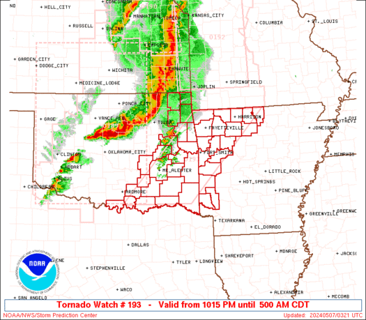
 STATUS REPORT ON WW 193 THE SEVERE WEATHER THREAT CONTINUES ACROSS THE ENTIRE WATCH AREA. ..WENDT..05/07/24 ATTN...WFO...LZK...TSA...SHV...OUN... STATUS REPORT FOR WT 193 SEVERE WEATHER THREAT CONTINUES FOR THE FOLLOWING AREAS ARC005-007-009-015-033-047-061-071-083-087-089-101-113-127-129-
131-133-143-070740- AR . ARKANSAS COUNTIES INCLUDED ARE BAXTER BENTON BOONE CARROLL CRAWFORD FRANKLIN HOWARD JOHNSON LOGAN MADISON MARION NEWTON POLK SCOTT SEARCY SEBASTIAN SEVIER WASHINGTON OKC001-005-013-019-021-023-029-035-041-049-061-063-067-069-077-
079-085-089-091-095-097-099-101-115-121-123-125-127-133-135-137-
070740- OK . OKLAHOMA COUNTIES INCLUDED ARE ADAIR ATOKA BRYAN CARTER CHEROKEE CHOCTAW COAL CRAIG DELAWARE GARVIN HASKELL HUGHES JEFFERSON JOHNSTON LATIMER

WW 193 TORNADO AR OK 070315Z – 071000Z
 URGENT - IMMEDIATE BROADCAST REQUESTED
Tornado Watch Number 193
NWS Storm Prediction Center Norman OK
1015 PM CDT Mon May 6 2024 The NWS Storm Prediction Center has issued a * Tornado Watch for portions of Western and Northern Arkansas Eastern and Southern Oklahoma * Effective this Monday night and Tuesday morning from 1015 PM until 500 AM CDT. * Primary threats include... A few tornadoes likely with a couple intense tornadoes possible Widespread damaging wind gusts to 70 mph likely Isolated large hail events to 1.5 inches in diameter possible SUMMARY...Severe storm and tornado potential is expected to increase
into the overnight across the region, initially across northeast
Oklahoma. This includes the potential for tornadoes, damaging winds
and hail. The tornado watch area is approximately along and 65 statute miles
east and west of a line from 20 miles northwest of Harrison AR to 30
miles east of Durant OK. For a complete depiction of the watch see
the associated watch outline update (WOUS64 KWNS WOU3). PRECAUTIONARY/PREPAREDNESS ACTIONS... REMEMBER...A Tornado Watch means conditions are favorable for
tornadoes and severe thunderstorms in and close to the watch
area. Persons in these areas should be on the lookout for
threatening weather conditions and listen for later statements
and possible warnings. && OTHER WATCH INFORMATION...CONTINUE...WW 189...WW 190...WW
191...WW 192... AVIATION...Tornadoes and a few severe thunderstorms with hail
surface and aloft to 1.5 inches. Extreme turbulence and surface wind
gusts to 60 knots. A few cumulonimbi with maximum tops to 550. Mean
storm motion vector 23035. ...Guyer

WW 0194 Status Updates 
 STATUS REPORT ON WW 194 THE SEVERE WEATHER THREAT CONTINUES ACROSS THE ENTIRE WATCH AREA. ..WENDT..05/07/24 ATTN...WFO...LSX...ILX...PAH...SGF... STATUS REPORT FOR WT 194 SEVERE WEATHER THREAT CONTINUES FOR THE FOLLOWING AREAS ILC001-009-013-017-061-083-117-119-133-137-149-157-163-169-171-
070740- IL . ILLINOIS COUNTIES INCLUDED ARE ADAMS BROWN CALHOUN CASS GREENE JERSEY MACOUPIN MADISON MONROE MORGAN PIKE RANDOLPH ST. CLAIR SCHUYLER SCOTT MOC007-017-019-023-027-035-051-055-065-071-073-091-093-099-103-
111-113-123-125-127-131-135-137-139-149-151-157-161-163-169-173-
179-181-183-186-187-189-203-205-215-219-221-223-510-070740- MO . MISSOURI COUNTIES INCLUDED ARE AUDRAIN BOLLINGER BOONE BUTLER CALLAWAY CARTER COLE CRAWFORD DENT FRANKLIN GASCONADE HOWELL IRON JEFFERSON KNOX LEWIS LINCOLN MADISON

WW 194 TORNADO IL MO 070550Z – 071300Z
 URGENT - IMMEDIATE BROADCAST REQUESTED
Tornado Watch Number 194
NWS Storm Prediction Center Norman OK
1250 AM CDT Tue May 7 2024 The NWS Storm Prediction Center has issued a * Tornado Watch for portions of Western Illinois Eastern Missouri * Effective this Tuesday morning from 1250 AM until 800 AM CDT. * Primary threats include... A couple tornadoes possible Scattered damaging wind gusts to 70 mph possible Isolated large hail events to 1 inch in diameter possible SUMMARY...A line of strong-severe thunderstorms will continue to
pose a threat for severe gusts and a few embedded tornadoes as it
moves eastward into the Mississippi River Valley through early
morning. The tornado watch area is approximately along and 65 statute miles
east and west of a line from 40 miles west southwest of Poplar Bluff
MO to 20 miles north northeast of Quincy IL. For a complete
depiction of the watch see the associated watch outline update
(WOUS64 KWNS WOU4). PRECAUTIONARY/PREPAREDNESS ACTIONS... REMEMBER...A Tornado Watch means conditions are favorable for
tornadoes and severe thunderstorms in and close to the watch
area. Persons in these areas should be on the lookout for
threatening weather conditions and listen for later statements
and possible warnings. && OTHER WATCH INFORMATION...CONTINUE...WW 191...WW 192...WW 193... AVIATION...Tornadoes and a few severe thunderstorms with hail
surface and aloft to 1 inch. Extreme turbulence and surface wind
gusts to 60 knots. A few cumulonimbi with maximum tops to 500. Mean
storm motion vector 27045. ...Edwards