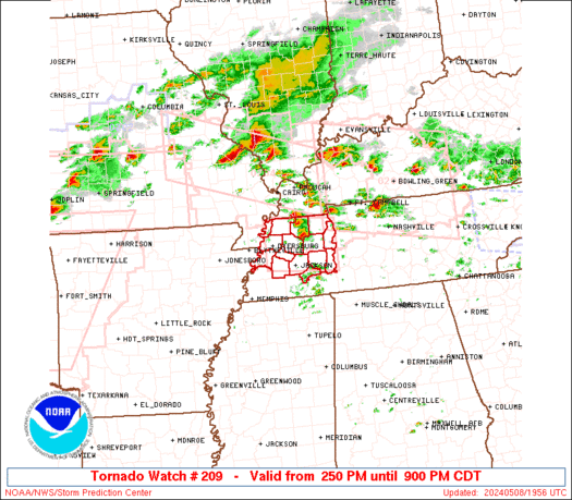
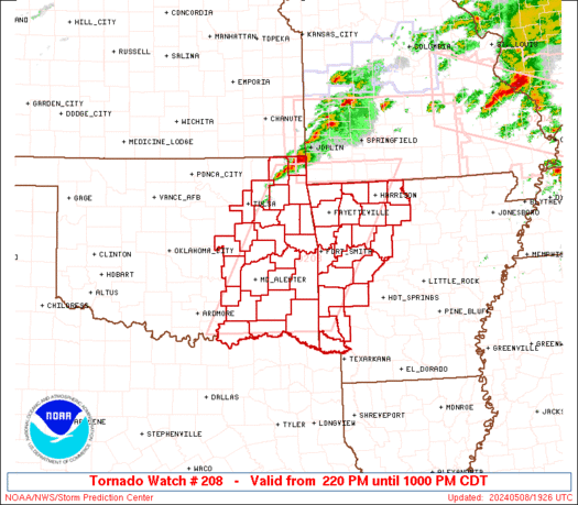
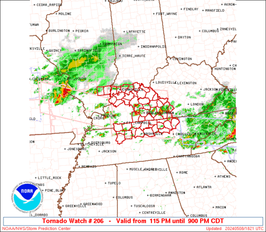
SPC Tornado Watch 210

WW 210 TORNADO AR TX 082025Z – 090300Z
WW 0210 Image

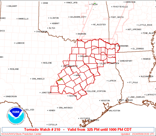
 URGENT - IMMEDIATE BROADCAST REQUESTED
Tornado Watch Number 210
NWS Storm Prediction Center Norman OK
325 PM CDT Wed May 8 2024 The NWS Storm Prediction Center has issued a * Tornado Watch for portions of Southwest Arkansas Central and North and Northeast Texas * Effective this Wednesday afternoon and evening from 325 PM until 1000 PM CDT. * Primary threats include... A couple tornadoes possible Scattered large hail and isolated very large hail events to 4 inches in diameter likely Scattered damaging wind gusts to 70 mph likely SUMMARY...Isolated supercells are forecast to develop southward
along the dryline in north and central Texas this afternoon. A very
moist and extremely unstable airmass will be favorable for giant
hail with the more intense updrafts. The risk for a tornado may
maximize with any mature supercell that can locally augment
low-level shear later this afternoon into the evening. A cluster of
severe storms may develop towards evening over northeast Texas and
pose a risk for all severe hazards. The tornado watch area is approximately along and 80 statute miles
east and west of a line from 20 miles north of Paris TX to 55 miles
south southwest of Temple TX. For a complete depiction of the watch
see the associated watch outline update (WOUS64 KWNS WOU0). PRECAUTIONARY/PREPAREDNESS ACTIONS... REMEMBER...A Tornado Watch means conditions are favorable for
tornadoes and severe thunderstorms in and close to the watch
area. Persons in these areas should be on the lookout for
threatening weather conditions and listen for later statements
and possible warnings. && OTHER WATCH INFORMATION...CONTINUE...WW 204...WW 205...WW
206...WW 207...WW 208...WW 209... AVIATION...Tornadoes and a few severe thunderstorms with hail
surface and aloft to 4 inches. Extreme turbulence and surface wind
gusts to 60 knots. A few cumulonimbi with maximum tops to 500. Mean
storm motion vector 24025. ...Smith 

Read more

SPC Tornado Watch 209

WW 209 TORNADO TN 081950Z – 090200Z
WW 0209 Image

 URGENT - IMMEDIATE BROADCAST REQUESTED
Tornado Watch Number 209
NWS Storm Prediction Center Norman OK
250 PM CDT Wed May 8 2024 The NWS Storm Prediction Center has issued a * Tornado Watch for portions of Northwest Tennessee * Effective this Wednesday afternoon and evening from 250 PM until 900 PM CDT. * Primary threats include... A few tornadoes likely with a couple intense tornadoes possible Scattered large hail and isolated very large hail events to 2.5 inches in diameter likely Scattered damaging wind gusts to 70 mph likely SUMMARY...A few supercells are expected this afternoon/evening along
a remnant outflow boundary across northwest Tennessee. A few
tornadoes, including a strong (EF2+) tornado or two, large hail up
to 2.5 inches in diameter and damaging gusts to 70 mph will be
possible. The tornado watch area is approximately along and 35 statute miles
north and south of a line from 10 miles west northwest of Dyersburg
TN to 60 miles east northeast of Jackson TN. For a complete
depiction of the watch see the associated watch outline update
(WOUS64 KWNS WOU9). PRECAUTIONARY/PREPAREDNESS ACTIONS... REMEMBER...A Tornado Watch means conditions are favorable for
tornadoes and severe thunderstorms in and close to the watch
area. Persons in these areas should be on the lookout for
threatening weather conditions and listen for later statements
and possible warnings. && OTHER WATCH INFORMATION...CONTINUE...WW 203...WW 204...WW
205...WW 206...WW 207...WW 208... AVIATION...Tornadoes and a few severe thunderstorms with hail
surface and aloft to 2.5 inches. Extreme turbulence and surface wind
gusts to 60 knots. A few cumulonimbi with maximum tops to 550. Mean
storm motion vector 27025. ...Thompson 

Read more

SPC Tornado Watch 208

WW 208 TORNADO AR OK 081920Z – 090300Z
WW 0208 Image

 URGENT - IMMEDIATE BROADCAST REQUESTED
Tornado Watch Number 208
NWS Storm Prediction Center Norman OK
220 PM CDT Wed May 8 2024 The NWS Storm Prediction Center has issued a * Tornado Watch for portions of Western Arkansas Eastern Oklahoma * Effective this Wednesday afternoon and evening from 220 PM until 1000 PM CDT. * Primary threats include... A few tornadoes likely with a couple intense tornadoes possible Scattered damaging winds and isolated significant gusts to 75 mph likely Scattered large hail and isolated very large hail events to 4 inches in diameter likely SUMMARY...Scattered supercells are forecast to develop across
eastern Oklahoma late this afternoon and move into western Arkansas
late this afternoon into the evening. Giant hail is possible with
the more intense supercells, in addition to the risk for a strong
tornado. The tornado watch area is approximately along and 75 statute miles
east and west of a line from Monett MO to 50 miles east of Durant
OK. For a complete depiction of the watch see the associated watch
outline update (WOUS64 KWNS WOU8). PRECAUTIONARY/PREPAREDNESS ACTIONS... REMEMBER...A Tornado Watch means conditions are favorable for
tornadoes and severe thunderstorms in and close to the watch
area. Persons in these areas should be on the lookout for
threatening weather conditions and listen for later statements
and possible warnings. && OTHER WATCH INFORMATION...CONTINUE...WW 203...WW 204...WW
205...WW 206...WW 207... AVIATION...Tornadoes and a few severe thunderstorms with hail
surface and aloft to 4 inches. Extreme turbulence and surface wind
gusts to 65 knots. A few cumulonimbi with maximum tops to 500. Mean
storm motion vector 25030. ...Smith 

Read more

SPC Severe Thunderstorm Watch 207

WW 207 SEVERE TSTM NC SC 081905Z – 090200Z
WW 0207 Image

 URGENT - IMMEDIATE BROADCAST REQUESTED
Severe Thunderstorm Watch Number 207
NWS Storm Prediction Center Norman OK
305 PM EDT Wed May 8 2024 The NWS Storm Prediction Center has issued a * Severe Thunderstorm Watch for portions of South-Central North Carolina Central South Carolina * Effective this Wednesday afternoon and evening from 305 PM until 1000 PM EDT. * Primary threats include... Scattered damaging wind gusts to 70 mph likely Scattered large hail and isolated very large hail events to 2 inches in diameter possible SUMMARY...A cluster of strong to severe thunderstorms is expected to
move into the Watch area from the west this afternoon into the
evening. Severe gusts and associated wind damage and large hail
will be the primary severe hazards. The severe thunderstorm watch area is approximately along and 55
statute miles north and south of a line from 20 miles south
southwest of Charlotte NC to 45 miles southeast of Fayetteville NC.
For a complete depiction of the watch see the associated watch
outline update (WOUS64 KWNS WOU7). PRECAUTIONARY/PREPAREDNESS ACTIONS... REMEMBER...A Severe Thunderstorm Watch means conditions are
favorable for severe thunderstorms in and close to the watch area.
Persons in these areas should be on the lookout for threatening
weather conditions and listen for later statements and possible
warnings. Severe thunderstorms can and occasionally do produce
tornadoes. && OTHER WATCH INFORMATION...CONTINUE...WW 203...WW 204...WW
205...WW 206... AVIATION...A few severe thunderstorms with hail surface and aloft to
2 inches. Extreme turbulence and surface wind gusts to 60 knots. A
few cumulonimbi with maximum tops to 500. Mean storm motion vector
26030. ...Smith 

Read more