Month: May 2024
SPC Tornado Watch 214
WW 214 TORNADO AL GA NC SC TN 090310Z – 090800Z 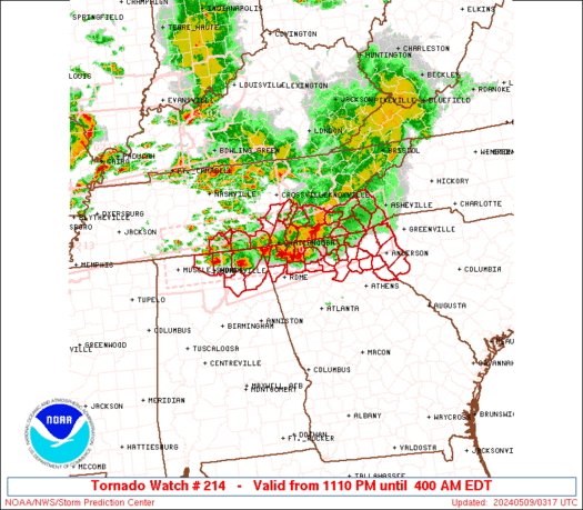
 URGENT - IMMEDIATE BROADCAST REQUESTED
Tornado Watch Number 214
NWS Storm Prediction Center Norman OK
1110 PM EDT Wed May 8 2024 The NWS Storm Prediction Center has issued a * Tornado Watch for portions of Northeast Alabama Northern Georgia Southwest North Carolina Western South Carolina Southeast Tennessee * Effective this Wednesday night and Thursday morning from 1110 PM until 400 AM EDT. * Primary threats include... A few tornadoes likely with a couple intense tornadoes possible Scattered large hail and isolated very large hail events to 2 inches in diameter likely Scattered damaging wind gusts to 70 mph likely SUMMARY...Numerous severe thunderstorms continue from northern
Alabama into northern Georgia and southeast Tennessee. These storms
will track eastward overnight across the watch area, while new
isolated storms develop and move in from the west. Damaging winds
and tornadoes are possible with these storms. The tornado watch area is approximately along and 40 statute miles
north and south of a line from 85 miles west southwest of
Chattanooga TN to 20 miles south of Asheville NC. For a complete
depiction of the watch see the associated watch outline update
(WOUS64 KWNS WOU4). PRECAUTIONARY/PREPAREDNESS ACTIONS... REMEMBER...A Tornado Watch means conditions are favorable for
tornadoes and severe thunderstorms in and close to the watch
area. Persons in these areas should be on the lookout for
threatening weather conditions and listen for later statements
and possible warnings. && OTHER WATCH INFORMATION...CONTINUE...WW 211...WW 212...WW 213... AVIATION...Tornadoes and a few severe thunderstorms with hail
surface and aloft to 2 inches. Extreme turbulence and surface wind
gusts to 60 knots. A few cumulonimbi with maximum tops to 500. Mean
storm motion vector 27030. ...Hart
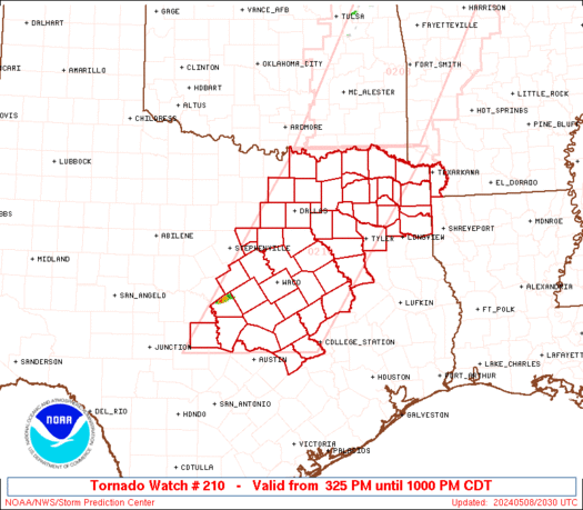
SPC Tornado Watch 213
WW 213 TORNADO AR MO MS TN 090115Z – 090800Z 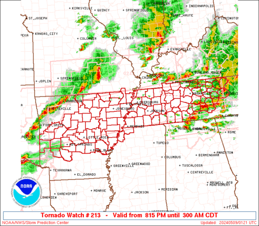
 URGENT - IMMEDIATE BROADCAST REQUESTED
Tornado Watch Number 213
NWS Storm Prediction Center Norman OK
815 PM CDT Wed May 8 2024 The NWS Storm Prediction Center has issued a * Tornado Watch for portions of Central and Northern Arkansas Missouri Bootheel Northwest Mississippi Western and Middle Tennessee * Effective this Wednesday night and Thursday morning from 815 PM until 300 AM CDT. * Primary threats include... A few tornadoes likely with a couple intense tornadoes possible Widespread large hail and scattered very large hail events to 3 inches in diameter likely Widespread damaging winds and isolated significant gusts to 80 mph likely SUMMARY...Multiple rounds of severe thunderstorms will continue to
occur across the watch area into the overnight period. Supercells
and bowing storms capable of damaging winds, large hail, and
tornadoes will be possible. The tornado watch area is approximately along and 55 statute miles
north and south of a line from 50 miles west of Russellville AR to
10 miles north northeast of Crossville TN. For a complete depiction
of the watch see the associated watch outline update (WOUS64 KWNS
WOU3). PRECAUTIONARY/PREPAREDNESS ACTIONS... REMEMBER...A Tornado Watch means conditions are favorable for
tornadoes and severe thunderstorms in and close to the watch
area. Persons in these areas should be on the lookout for
threatening weather conditions and listen for later statements
and possible warnings. && OTHER WATCH INFORMATION...CONTINUE...WW 206...WW 208...WW
209...WW 210...WW 211...WW 212... AVIATION...Tornadoes and a few severe thunderstorms with hail
surface and aloft to 3 inches. Extreme turbulence and surface wind
gusts to 70 knots. A few cumulonimbi with maximum tops to 500. Mean
storm motion vector 27035. ...Hart
US already hit by 7 billion-dollar disasters in 2024 and it’s only May

The first full month of spring was stormy, warm and snowy according to NOAA's April 2024 climate assessment. That means through April, this year is the fifth-hottest out of the nation's 130-year climate history, and the country has endured seven billion-dollar disasters so far.
SPC Tornado Watch 212
WW 212 TORNADO IL KY MO 082140Z – 090500Z 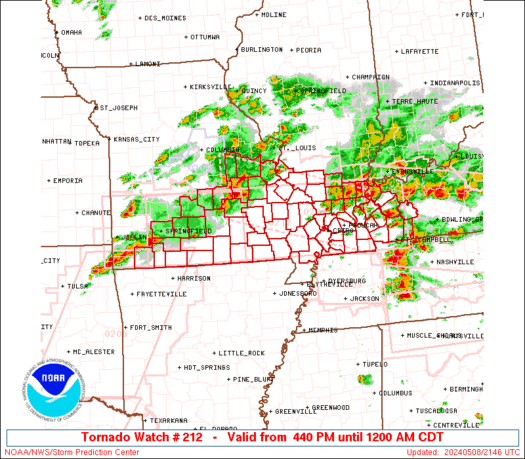
 URGENT - IMMEDIATE BROADCAST REQUESTED
Tornado Watch Number 212
NWS Storm Prediction Center Norman OK
440 PM CDT Wed May 8 2024 The NWS Storm Prediction Center has issued a * Tornado Watch for portions of Southern Illinois Western Kentucky Southern Missouri * Effective this Wednesday afternoon from 440 PM until Midnight CDT. * Primary threats include... A few tornadoes and a couple intense tornadoes likely Widespread large hail and scattered very large hail events to 2.5 inches in diameter likely Widespread damaging winds and isolated significant gusts to 75 mph likely SUMMARY...Multiple rounds of severe thunderstorms will affect the
watch area through the afternoon and evening, posing a risk of large
hail and damaging winds. A few tornadoes are also expected. The tornado watch area is approximately along and 50 statute miles
north and south of a line from 20 miles west of Springfield MO to 40
miles north northeast of Fort Campbell KY. For a complete depiction
of the watch see the associated watch outline update (WOUS64 KWNS
WOU2). PRECAUTIONARY/PREPAREDNESS ACTIONS... REMEMBER...A Tornado Watch means conditions are favorable for
tornadoes and severe thunderstorms in and close to the watch
area. Persons in these areas should be on the lookout for
threatening weather conditions and listen for later statements
and possible warnings. && OTHER WATCH INFORMATION...CONTINUE...WW 204...WW 205...WW
206...WW 207...WW 208...WW 209...WW 210...WW 211... AVIATION...Tornadoes and a few severe thunderstorms with hail
surface and aloft to 2.5 inches. Extreme turbulence and surface wind
gusts to 65 knots. A few cumulonimbi with maximum tops to 500. Mean
storm motion vector 26035. ...Hart
SPC Tornado Watch 211
WW 211 TORNADO AL GA NC TN 082115Z – 090400Z 
 URGENT - IMMEDIATE BROADCAST REQUESTED
Tornado Watch Number 211
NWS Storm Prediction Center Norman OK
515 PM EDT Wed May 8 2024 The NWS Storm Prediction Center has issued a * Tornado Watch for portions of Northern Alabama Northern Georgia Far western North Carolina Eastern Tennessee * Effective this Wednesday afternoon from 515 PM until Midnight EDT. * Primary threats include... A couple tornadoes possible Scattered large hail likely with isolated very large hail events to 2 inches in diameter possible Scattered damaging wind gusts to 70 mph likely SUMMARY...A few supercells will be possible this evening along a
remnant outflow boundary, where a couple of tornadoes will be
possible. Otherwise, additional storms could spread into this area
later this evening with an accompanying threat for damaging winds up
to 70 mph and large hail up to 2 inches in diameter. The tornado watch area is approximately along and 40 statute miles
north and south of a line from 25 miles northwest of Muscle Shoals
AL to 75 miles east of Chattanooga TN. For a complete depiction of
the watch see the associated watch outline update (WOUS64 KWNS
WOU1). PRECAUTIONARY/PREPAREDNESS ACTIONS... REMEMBER...A Tornado Watch means conditions are favorable for
tornadoes and severe thunderstorms in and close to the watch
area. Persons in these areas should be on the lookout for
threatening weather conditions and listen for later statements
and possible warnings. && OTHER WATCH INFORMATION...CONTINUE...WW 204...WW 205...WW
206...WW 207...WW 208...WW 209...WW 210... AVIATION...Tornadoes and a few severe thunderstorms with hail
surface and aloft to 2 inches. Extreme turbulence and surface wind
gusts to 60 knots. A few cumulonimbi with maximum tops to 550. Mean
storm motion vector 27025. ...Thompson