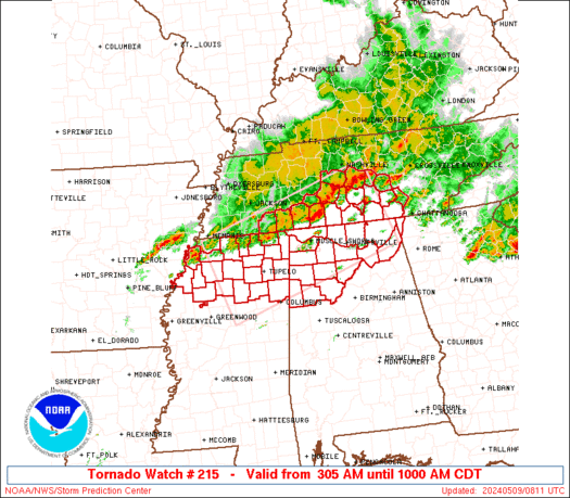
🔴 LIVE TEXAS CHASE – Large Hail, Enhanced Risk Coverage

🔴 LIVE TEXAS CHASE – Large Hail, Enhanced Risk Coverage

Join this channel to get access to perks: https://www.youtube.com/channel/UCNPvoDpoOWevcdTHr8GyTyA/join Our chasers Adam, Jason and Chelsea are chasing severe storms capable of large hail and a few tornadoes in North Texas and the DFW Metroplex (May 9, 2024) #IRL #Tornado #StormChasers NOT for rebroadcast or embedding. Email us at contact@texasstormchasers.com for licensing inquiries. Check out our […]

🔴 May 9, 2024 LIVE Texas Severe Weather & Tornado Coverage

🔴 May 9, 2024 LIVE Texas Severe Weather & Tornado Coverage

Live coverage and updates on severe thunderstorms impacting portions of Texas from the @texasstormchasers team… Join this channel to get access to perks: https://www.youtube.com/channel/UCoIfgmxArIATc2EpHD3W9EA/join Check out our current LIVE STREAM: https://texasweather.video/ Our FREE WEATHER APP: https://texasweather.app/ Our WEBSITE/RADAR: https://www.texasstormchasers.com Our SOCIAL PLATFORMS: https://linktr.ee/texasstormchasers Donations – Paypal@texasstormchasers.com *Enable 4K 60FPS when possible for best viewing results* […]

Rambunctious Texas Storms Likely This Afternoon and Evening

Rambunctious Texas Storms Likely This Afternoon and Evening

Scattered thunderstorms will likely make for a rough day in the weather department across parts of Texas. Unlike yesterday where most storms held off until after dinner-time, we’ll get an earlier start by the early afternoon hours in North Texas. Initial thunderstorms may develop in western North Texas, and move east into the D/FW Metroplex […]

SPC Tornado Watch 216

WW 216 TORNADO GA NC TN 090945Z – 091700Z
WW 0216 Image

 URGENT - IMMEDIATE BROADCAST REQUESTED
Tornado Watch Number 216
NWS Storm Prediction Center Norman OK
545 AM EDT Thu May 9 2024 The NWS Storm Prediction Center has issued a * Tornado Watch for portions of Northern and central Georgia Extreme western North Carolina Extreme southeastern Tennessee * Effective this Thursday morning and afternoon from 545 AM until 100 PM EDT. * Primary threats include... A couple tornadoes possible Scattered damaging wind gusts to 70 mph likely Isolated large hail events to 1.5 inches in diameter possible SUMMARY...An organizing complex of severe thunderstorms is expected
to move southeastward astride an outflow boundary from prior
activity. This will focus a corridor of damaging-wind potential,
with a few tornadoes and isolated severe hail possible through the
rest of the morning. The tornado watch area is approximately along and 60 statute miles
either side of a line from 45 miles north of Rome GA to 55 miles
east northeast of Macon GA. For a complete depiction of the watch
see the associated watch outline update (WOUS64 KWNS WOU6). PRECAUTIONARY/PREPAREDNESS ACTIONS... REMEMBER...A Tornado Watch means conditions are favorable for
tornadoes and severe thunderstorms in and close to the watch
area. Persons in these areas should be on the lookout for
threatening weather conditions and listen for later statements
and possible warnings. && OTHER WATCH INFORMATION...CONTINUE...WW 215... AVIATION...Tornadoes and a few severe thunderstorms with hail
surface and aloft to 1.5 inches. Extreme turbulence and surface wind
gusts to 60 knots. A few cumulonimbi with maximum tops to 500. Mean
storm motion vector 31035. ...Edwards 

Read more

SPC Tornado Watch 215

WW 215 TORNADO AL GA MS TN 090805Z – 091500Z
WW 0215 Image

 URGENT - IMMEDIATE BROADCAST REQUESTED
Tornado Watch Number 215
NWS Storm Prediction Center Norman OK
305 AM CDT Thu May 9 2024 The NWS Storm Prediction Center has issued a * Tornado Watch for portions of Northern Alabama Extreme northwestern Georgia Northern Mississippi Middle Tennessee * Effective this Thursday morning from 305 AM until 1000 AM CDT. * Primary threats include... A couple tornadoes possible Scattered large hail and isolated very large hail events to 2 inches in diameter possible Scattered damaging wind gusts to 70 mph possible SUMMARY...A complex of thunderstorms is expected to move
east-southeastward over the watch area, episodically posing a threat
for damaging wind and tornadoes. The tornado watch area is approximately along and 60 statute miles
either side of a line from 25 miles southwest of Oxford MS to 70
miles northeast of Huntsville AL. For a complete depiction of the
watch see the associated watch outline update (WOUS64 KWNS WOU5). PRECAUTIONARY/PREPAREDNESS ACTIONS... REMEMBER...A Tornado Watch means conditions are favorable for
tornadoes and severe thunderstorms in and close to the watch
area. Persons in these areas should be on the lookout for
threatening weather conditions and listen for later statements
and possible warnings. && OTHER WATCH INFORMATION...CONTINUE...WW 213...WW 214... AVIATION...Tornadoes and a few severe thunderstorms with hail
surface and aloft to 2 inches. Extreme turbulence and surface wind
gusts to 60 knots. A few cumulonimbi with maximum tops to 500. Mean
storm motion vector 29030. ...Edwards 

Read more

What is the Main Development Region (MDR) of the North Atlantic Ocean?

What is the Main Development Region (MDR) of the North Atlantic Ocean?

A common frequently asked hurricane question is, ‘What is the Main Development region?’ Well, there is not a scientific standard for the MDR, but many meteorologists consider it to be the region between Africa and the Lesser Antilles, where the majority of tropical cyclones form. Climatologists estimate that 85% of major hurricanes and 60% of all other tropical cyclones form in either the Caribbean or the Atlantic MDR.

LIVE North Texas Storm Chase / Tornado Warning Coverage (5/8/24) {D-C-S}

LIVE North Texas Storm Chase / Tornado Warning Coverage (5/8/24) {D-C-S}

Join this channel to get access to perks: https://www.youtube.com/channel/UCNPvoDpoOWevcdTHr8GyTyA/join Our chasers Adam, Stephen, Jason and Chelsea are covering today’s Enhanced to Moderate Severe Risk threat across parts of #Texas to #Missouri (May 8, 2024) #IRL #Tornado #StormChasers NOT for rebroadcast or embedding. Email us at contact@texasstormchasers.com for licensing inquiries. Check out our LIVE STREAM: https://texasweather.video/ […]