Month: May 2024
SPC Severe Thunderstorm Watch 219
WW 219 SEVERE TSTM OK TX 091725Z – 100000Z 
 URGENT - IMMEDIATE BROADCAST REQUESTED
Severe Thunderstorm Watch Number 219
NWS Storm Prediction Center Norman OK
1225 PM CDT Thu May 9 2024 The NWS Storm Prediction Center has issued a * Severe Thunderstorm Watch for portions of Southern Oklahoma North Texas * Effective this Thursday afternoon and evening from 1225 PM until 700 PM CDT. * Primary threats include... Scattered large hail and isolated very large hail events to 3.5 inches in diameter likely Scattered damaging wind gusts to 70 mph possible SUMMARY...Several supercells are forecast to move across the Watch
area this afternoon into the early evening. Large to giant hail
will be likely with any robust supercell and severe gusts are also
possible. The severe thunderstorm watch area is approximately along and 55
statute miles north and south of a line from 30 miles southwest of
Wichita Falls TX to 30 miles east southeast of Durant OK. For a
complete depiction of the watch see the associated watch outline
update (WOUS64 KWNS WOU9). PRECAUTIONARY/PREPAREDNESS ACTIONS... REMEMBER...A Severe Thunderstorm Watch means conditions are
favorable for severe thunderstorms in and close to the watch area.
Persons in these areas should be on the lookout for threatening
weather conditions and listen for later statements and possible
warnings. Severe thunderstorms can and occasionally do produce
tornadoes. && OTHER WATCH INFORMATION...CONTINUE...WW 217...WW 218... AVIATION...A few severe thunderstorms with hail surface and aloft to
3.5 inches. Extreme turbulence and surface wind gusts to 60 knots. A
few cumulonimbi with maximum tops to 500. Mean storm motion vector
24030. ...Smith
What is a derecho?

A derecho is a cluster of thunderstorms that produces destructive wind gusts for hundreds of miles and has the potential to impact millions of people.
SPC Tornado Watch 218
WW 218 TORNADO GA SC CW 091610Z – 092300Z 
 URGENT - IMMEDIATE BROADCAST REQUESTED
Tornado Watch Number 218
NWS Storm Prediction Center Norman OK
1210 PM EDT Thu May 9 2024 The NWS Storm Prediction Center has issued a * Tornado Watch for portions of Southeast Georgia Southern South Carolina Coastal Waters * Effective this Thursday afternoon and evening from 1210 PM until 700 PM EDT. * Primary threats include... A couple tornadoes possible Scattered damaging wind gusts to 70 mph likely Isolated large hail events to 1.5 inches in diameter possible SUMMARY...Intensifying bands of storms will move into the Watch area
this afternoon and into the early evening. The stronger storms will
probably include a mix of line segments and a few supercells. The
more intense storms will potentially be capable of damaging gusts
and a couple of tornadoes. The tornado watch area is approximately along and 55 statute miles
north and south of a line from 60 miles west northwest of Savannah
GA to 35 miles east southeast of Charleston SC. For a complete
depiction of the watch see the associated watch outline update
(WOUS64 KWNS WOU8). PRECAUTIONARY/PREPAREDNESS ACTIONS... REMEMBER...A Tornado Watch means conditions are favorable for
tornadoes and severe thunderstorms in and close to the watch
area. Persons in these areas should be on the lookout for
threatening weather conditions and listen for later statements
and possible warnings. && OTHER WATCH INFORMATION...CONTINUE...WW 216...WW 217... AVIATION...Tornadoes and a few severe thunderstorms with hail
surface and aloft to 1.5 inches. Extreme turbulence and surface wind
gusts to 60 knots. A few cumulonimbi with maximum tops to 500. Mean
storm motion vector 26035. ...Smith
Hot and humid Thursday, then a cool front sends changes in for Mother’s Day Weekend
Not a washout, but a few showers and isolated storms can’t be ruled out on Mother’s Day
Nashville community finds hope amid deadly destruction after onslaught of tornadoes tear through Tennessee

The sun now shines in Middle Tennessee, where some of humanity's best is illuminated during a very dark time for one community.
El Nino stubbornly clings to life but hurricane-fueling La Nina pattern still looms

Tropical Pacific Ocean conditions are still clinging to some above-average warmth in critical parts of the eastern and central regions that just meet their minimum threshold of at least 0.5 degrees Celsius for maintaining an El Niño Advisory.
SPC Tornado Watch 217
WW 217 TORNADO AL GA 091350Z – 092100Z 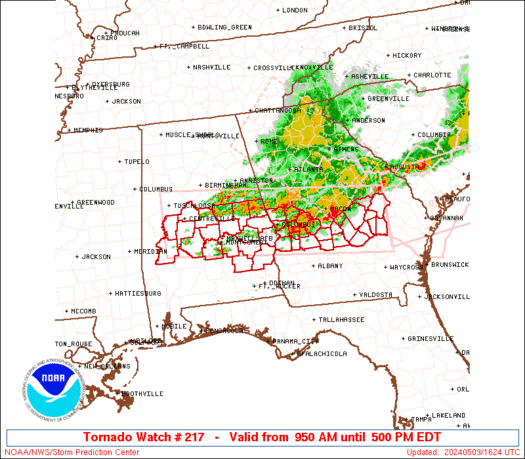
 URGENT - IMMEDIATE BROADCAST REQUESTED
Tornado Watch Number 217
NWS Storm Prediction Center Norman OK
950 AM EDT Thu May 9 2024 The NWS Storm Prediction Center has issued a * Tornado Watch for portions of Central and Eastern Alabama Central Georgia * Effective this Thursday morning and afternoon from 950 AM until 500 PM EDT. * Primary threats include... A couple tornadoes possible Widespread damaging wind gusts to 70 mph likely Scattered large hail likely with isolated very large hail events to 2 inches in diameter possible SUMMARY...Bands of strong to severe storms will likely continue to
push east-southeast across the Watch area through the early to mid
afternoon. A few supercells are possible ahead of the main
thunderstorm bands and will also pose a severe risk, including the
threat for tornadoes and large hail. Damaging gusts will be the
primary hazard with the thunderstorm bands, but a tornado may also
accompany any embedded stronger circulations within the line. The tornado watch area is approximately along and 50 statute miles
north and south of a line from 30 miles south southwest of
Tuscaloosa AL to 15 miles east northeast of Vidalia GA. For a
complete depiction of the watch see the associated watch outline
update (WOUS64 KWNS WOU7). PRECAUTIONARY/PREPAREDNESS ACTIONS... REMEMBER...A Tornado Watch means conditions are favorable for
tornadoes and severe thunderstorms in and close to the watch
area. Persons in these areas should be on the lookout for
threatening weather conditions and listen for later statements
and possible warnings. && OTHER WATCH INFORMATION...CONTINUE...WW 215...WW 216... AVIATION...Tornadoes and a few severe thunderstorms with hail
surface and aloft to 2 inches. Extreme turbulence and surface wind
gusts to 60 knots. A few cumulonimbi with maximum tops to 500. Mean
storm motion vector 26035. ...Smith