SPC – No watches are valid as of Sat May 11 01:02:02 UTC 2024
No watches are valid as of Sat May 11 01:02:02 UTC 2024.
24/7 Tornado Newsfeed
No watches are valid as of Sat May 11 01:02:02 UTC 2024.
 in Texas Tonight? Wet Weekend Ahead!")
Showers and thunderstorms will bring rain chances to Texas over the weekend. The overall risk of severe storms remains on the lower side and is isolated. Most storms this weekend will behave themselves, though heavy rainfall may cause flooding problems across the eastern half of Texas by Sunday. Some parts of Texas may be in […]

Severe storms on Thursday across Texas produced giant hail and damaging winds. Local National Weather Service offices issue Severe Thunderstorm Warnings when hail is thought to be the size of quarters, but a Johnson City resident said her hailstone was the size of a melon.
WW 231 SEVERE TSTM NC SC CW 101750Z – 110100Z 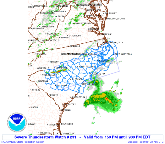
 URGENT - IMMEDIATE BROADCAST REQUESTED
Severe Thunderstorm Watch Number 231
NWS Storm Prediction Center Norman OK
150 PM EDT Fri May 10 2024 The NWS Storm Prediction Center has issued a * Severe Thunderstorm Watch for portions of Southern and eastern North Carolina Northern and northeastern South Carolina Coastal Waters * Effective this Friday afternoon and evening from 150 PM until 900 PM EDT. * Primary threats include... Scattered damaging wind gusts to 70 mph possible Scattered large hail events to 1.5 inches in diameter possible SUMMARY...Scattered thunderstorm development is expected along and
ahead of a weak cold front/surface trough, starting near the North
Carolina/South Carolina border and then spreading eastward and
southeastward through the evening. The storm environment will favor
a mix of supercells and bowing segments capable of producing large
hail of 1-1.5 inches in diameter and damaging gusts of 60-70 mph. The severe thunderstorm watch area is approximately along and 60
statute miles north and south of a line from 55 miles south of
Charlotte NC to 30 miles south southeast of Cape Hatteras NC. For a
complete depiction of the watch see the associated watch outline
update (WOUS64 KWNS WOU1). PRECAUTIONARY/PREPAREDNESS ACTIONS... REMEMBER...A Severe Thunderstorm Watch means conditions are
favorable for severe thunderstorms in and close to the watch area.
Persons in these areas should be on the lookout for threatening
weather conditions and listen for later statements and possible
warnings. Severe thunderstorms can and occasionally do produce
tornadoes. && AVIATION...A few severe thunderstorms with hail surface and aloft to
1.5 inches. Extreme turbulence and surface wind gusts to 60 knots. A
few cumulonimbi with maximum tops to 500. Mean storm motion vector
29030. ...Thompson
No watches are valid as of Fri May 10 15:13:01 UTC 2024.

A stunning event unfolded Wednesday evening on a North Carolina island after lightning struck three homes quickly within a seven-block radius.
According to the Weather Prediction Center, La Puerta, Texas reach 116 on Thursday. After sifting through records, this may be the hottest May temperature in Texas history.

A powerful weather system is drenching the Hawaiian Islands Friday, triggering flash flooding alerts across the state and even a Winter Storm Warning â yes, thatâs not a typo â for the mountain summits along the Big Island.