Cicadas: If you can’t beat them, eat them

Who is ready for the cicada-mageddon this year? Some people recommend turning to chefs instead of exterminators to handle the noisy bugs. Yes, some claim they are a tasty and nutritious treat.
24/7 Tornado Newsfeed
Who is ready for the cicada-mageddon this year? Some people recommend turning to chefs instead of exterminators to handle the noisy bugs. Yes, some claim they are a tasty and nutritious treat.
WW 250 SEVERE TSTM NM TX 162000Z – 170400Z 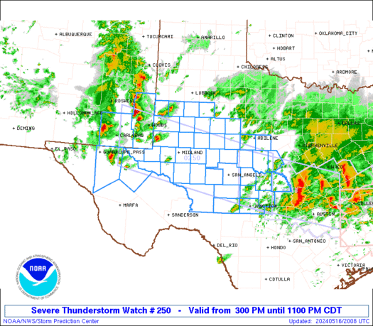
 URGENT - IMMEDIATE BROADCAST REQUESTED
Severe Thunderstorm Watch Number 250
NWS Storm Prediction Center Norman OK
300 PM CDT Thu May 16 2024 The NWS Storm Prediction Center has issued a * Severe Thunderstorm Watch for portions of Southeast New Mexico West Texas into the Edwards Plateau * Effective this Thursday afternoon and evening from 300 PM until 1100 PM CDT. * Primary threats include... Scattered large hail and isolated very large hail events to 2 inches in diameter possible Scattered damaging wind gusts to 70 mph possible SUMMARY...Thunderstorms will increase in coverage and intensity
through the afternoon/evening while spreading from southeast New
Mexico into west Texas and the Edwards Plateau. The main threats
will be large hail up to 2 inches in diameter with the more discrete
supercells, while severe outflow winds of 60-70 mph will be possible
as storms grow upscale into one or more line segments. The severe thunderstorm watch area is approximately along and 60
statute miles north and south of a line from 60 miles west southwest
of Hobbs NM to 60 miles northeast of Junction TX. For a complete
depiction of the watch see the associated watch outline update
(WOUS64 KWNS WOU0). PRECAUTIONARY/PREPAREDNESS ACTIONS... REMEMBER...A Severe Thunderstorm Watch means conditions are
favorable for severe thunderstorms in and close to the watch area.
Persons in these areas should be on the lookout for threatening
weather conditions and listen for later statements and possible
warnings. Severe thunderstorms can and occasionally do produce
tornadoes. && OTHER WATCH INFORMATION...CONTINUE...WW 248...WW 249... AVIATION...A few severe thunderstorms with hail surface and aloft to
2 inches. Extreme turbulence and surface wind gusts to 60 knots. A
few cumulonimbi with maximum tops to 500. Mean storm motion vector
29025. ...Thompson
WW 249 TORNADO LA TX CW 161940Z – 170300Z 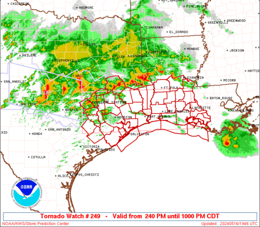
 URGENT - IMMEDIATE BROADCAST REQUESTED
Tornado Watch Number 249
NWS Storm Prediction Center Norman OK
240 PM CDT Thu May 16 2024 The NWS Storm Prediction Center has issued a * Tornado Watch for portions of Southwest Louisiana Southeast Texas Coastal Waters * Effective this Thursday afternoon and evening from 240 PM until 1000 PM CDT. * Primary threats include... A couple tornadoes possible Scattered damaging wind gusts to 70 mph likely Scattered large hail and isolated very large hail events to 2 inches in diameter possible SUMMARY...Clusters of storms will continue to develop and spread
east-southeastward through early tonight along a composite outflow
boundary sagging southward across east Texas. The potential for
supercells with large hail of 1-2 inches in diameter and a couple of
tornadoes will increase with new storm development south of the
outflow. Otherwise, embedded supercells and bowing segments will
pose a threat for damaging winds of 60-70 mph, as well as a couple
of tornadoes with embedded circulations. The tornado watch area is approximately along and 55 statute miles
north and south of a line from 40 miles southwest of College Station
TX to 5 miles east southeast of Lafayette LA. For a complete
depiction of the watch see the associated watch outline update
(WOUS64 KWNS WOU9). PRECAUTIONARY/PREPAREDNESS ACTIONS... REMEMBER...A Tornado Watch means conditions are favorable for
tornadoes and severe thunderstorms in and close to the watch
area. Persons in these areas should be on the lookout for
threatening weather conditions and listen for later statements
and possible warnings. && OTHER WATCH INFORMATION...CONTINUE...WW 248... AVIATION...Tornadoes and a few severe thunderstorms with hail
surface and aloft to 2 inches. Extreme turbulence and surface wind
gusts to 60 knots. A few cumulonimbi with maximum tops to 600. Mean
storm motion vector 28030. ...Thompson

NOAA scientists say coral reefs in the Caribbean are already showing early signs of heat stress in April starting even earlier than last summer.

Just like in SciFi where zombies are corpses that rise from the dead, zombie fires are wildfires that rise from the dead.
WW 248 SEVERE TSTM TX 161550Z – 162200Z 
 URGENT - IMMEDIATE BROADCAST REQUESTED
Severe Thunderstorm Watch Number 248
NWS Storm Prediction Center Norman OK
1050 AM CDT Thu May 16 2024 The NWS Storm Prediction Center has issued a * Severe Thunderstorm Watch for portions of Central Texas * Effective this Thursday morning and afternoon from 1050 AM until 500 PM CDT. * Primary threats include... Scattered large hail and isolated very large hail events to 2 inches in diameter likely Scattered damaging wind gusts to 70 mph likely A tornado or two possible SUMMARY...Clusters of storms, including both supercells and bowing
segments, are expected to continue to increase in coverage and
intensify into the afternoon, mainly along and south of an outflow
boundary that continues to move southward. Damaging winds of 60-70
mph will be the most common threat, though any more
discrete/supercell storms could produce large hail of 1-2 inches in
diameter. An isolated tornado or two could also occur with
favorable storm/boundary interactions. The severe thunderstorm watch area is approximately along and 55
statute miles north and south of a line from 60 miles north
northwest of Junction TX to 50 miles southeast of Temple TX. For a
complete depiction of the watch see the associated watch outline
update (WOUS64 KWNS WOU8). PRECAUTIONARY/PREPAREDNESS ACTIONS... REMEMBER...A Severe Thunderstorm Watch means conditions are
favorable for severe thunderstorms in and close to the watch area.
Persons in these areas should be on the lookout for threatening
weather conditions and listen for later statements and possible
warnings. Severe thunderstorms can and occasionally do produce
tornadoes. && AVIATION...A few severe thunderstorms with hail surface and aloft to
2 inches. Extreme turbulence and surface wind gusts to 60 knots. A
few cumulonimbi with maximum tops to 600. Mean storm motion vector
29030. ...Thompson

University students from around the U.S. are competing in Florida this week to see how each teamâs robot would fare on the surface of the Moon.