See it: Deadly storms wallops Houston as ferocious winds leave destructive path across South
Deadly severe storms have left hundreds of thousands in the dark, damaging homes and sending debris across city streets in Houston.
24/7 Tornado Newsfeed
Deadly severe storms have left hundreds of thousands in the dark, damaging homes and sending debris across city streets in Houston.
One more day of thunderstorm chances across parts of Texas before Mother Nature calms down and switches us to a summer-like weather pattern for several days. Get ready for triple-digit temperatures or heat-index values this weekend and for the first half of next week. The increasing heat will be problematic for those without power in […]
No watches are valid as of Fri May 17 08:02:02 UTC 2024.
A 3.8-magnitude earthquake was centered over northwest Tennessee, but the United States Geological Survey reports that the shaking was possibly felt more than 100 miles away from the epicenter.
WW 252 TORNADO AL MS CW 170350Z – 170800Z 
 URGENT - IMMEDIATE BROADCAST REQUESTED
Tornado Watch Number 252
NWS Storm Prediction Center Norman OK
1050 PM CDT Thu May 16 2024 The NWS Storm Prediction Center has issued a * Tornado Watch for portions of Southern Alabama Southern Mississippi Coastal Waters * Effective this Thursday night and Friday morning from 1050 PM until 300 AM CDT. * Primary threats include... A couple tornadoes possible Isolated damaging wind gusts to 70 mph possible SUMMARY...A severe squall line over southeast Louisiana will
continue east and move into the Watch area tonight. In addition to
the risk for a couple of tornadoes, severe gusts (60-70 mph) capable
of wind damage may accompany the more intense thunderstorm cores and
outflow surges in the squall line. The tornado watch area is approximately along and 30 statute miles
north and south of a line from 35 miles west of Gulfport MS to 30
miles southeast of Mobile AL. For a complete depiction of the watch
see the associated watch outline update (WOUS64 KWNS WOU2). PRECAUTIONARY/PREPAREDNESS ACTIONS... REMEMBER...A Tornado Watch means conditions are favorable for
tornadoes and severe thunderstorms in and close to the watch
area. Persons in these areas should be on the lookout for
threatening weather conditions and listen for later statements
and possible warnings. && OTHER WATCH INFORMATION...CONTINUE...WW 250...WW 251... AVIATION...Tornadoes and a few severe thunderstorms with hail
surface and aloft to 1.5 inches. Extreme turbulence and surface wind
gusts to 60 knots. A few cumulonimbi with maximum tops to 500. Mean
storm motion vector 27035. ...Smith
Videos from downtown Houston showed several buildings that had blown-out windows. The local National Weather Service office issued several Tornado Warnings for the area.
After a destructive round of severe thunderstorms moved through the Houston metro and Southeast Texas, those storms are moving off the Golden Triangle and into the Gulf of Mexico. We likely experienced winds of 100 to 120 MPH in some regions, and damage survey crews will probably confirm a few spinup tornadoes over the coming […]
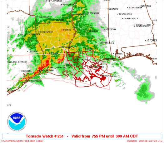
WW 251 TORNADO LA CW 170055Z – 170800Z 
 URGENT - IMMEDIATE BROADCAST REQUESTED
Tornado Watch Number 251
NWS Storm Prediction Center Norman OK
755 PM CDT Thu May 16 2024 The NWS Storm Prediction Center has issued a * Tornado Watch for portions of Southeast Louisiana Coastal Waters * Effective this Thursday night and Friday morning from 755 PM until 300 AM CDT. * Primary threats include... A couple tornadoes possible Scattered damaging winds and isolated significant gusts to 75 mph possible Isolated large hail events to 1.5 inches in diameter possible SUMMARY...A broken squall line will move east into southeast
Louisiana this evening and progress east across the Watch area
tonight. In addition to the risk for a couple of tornadoes, severe
gusts (60-75 mph) capable of wind damage may accompany the more
intense portions of the squall line. The tornado watch area is approximately along and 65 statute miles
north and south of a line from 5 miles north of Lafayette LA to 35
miles east of Boothville LA. For a complete depiction of the watch
see the associated watch outline update (WOUS64 KWNS WOU1). PRECAUTIONARY/PREPAREDNESS ACTIONS... REMEMBER...A Tornado Watch means conditions are favorable for
tornadoes and severe thunderstorms in and close to the watch
area. Persons in these areas should be on the lookout for
threatening weather conditions and listen for later statements
and possible warnings. && OTHER WATCH INFORMATION...CONTINUE...WW 249...WW 250... AVIATION...Tornadoes and a few severe thunderstorms with hail
surface and aloft to 1.5 inches. Extreme turbulence and surface wind
gusts to 65 knots. A few cumulonimbi with maximum tops to 500. Mean
storm motion vector 27035. ...Smith