Month: May 2024
SPC PDS Severe Thunderstorm Watch 260
WW 260 SEVERE TSTM KS OK TX 191935Z – 200300Z 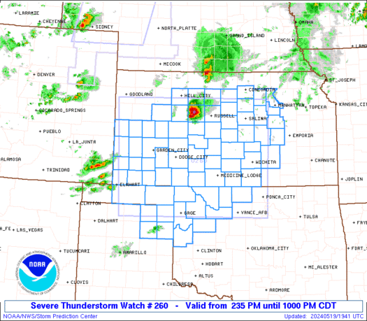
 URGENT - IMMEDIATE BROADCAST REQUESTED
Severe Thunderstorm Watch Number 260
NWS Storm Prediction Center Norman OK
235 PM CDT Sun May 19 2024 The NWS Storm Prediction Center has issued a * Severe Thunderstorm Watch for portions of Western and Central Kansas Northwestern Oklahoma Northeastern Texas Panhandle * Effective this Sunday afternoon and evening from 235 PM until 1000 PM CDT. ...THIS IS A PARTICULARLY DANGEROUS SITUATION... * Primary threats include... Widespread damaging winds expected with scattered significant gusts to 90 mph likely Widespread large hail expected with scattered very large hail events to 4 inches in diameter likely A few tornadoes possible SUMMARY...Numerous severe thunderstorms are expected to develop and
track rapidly eastward across the watch area through the afternoon
evening. Supercells capable of giant hail, damaging winds, and
isolated tornadoes will be the main threat early. Storms will
organize into multiple fast-moving bowing lines through the evening
with a risk of widespread damaging winds. The severe thunderstorm watch area is approximately along and 135
statute miles east and west of a line from 55 miles southwest of
Alva OK to 45 miles northwest of Russell KS. For a complete
depiction of the watch see the associated watch outline update
(WOUS64 KWNS WOU0). PRECAUTIONARY/PREPAREDNESS ACTIONS... REMEMBER...A Severe Thunderstorm Watch means conditions are
favorable for severe thunderstorms in and close to the watch area.
Persons in these areas should be on the lookout for threatening
weather conditions and listen for later statements and possible
warnings. Severe thunderstorms can and occasionally do produce
tornadoes. && OTHER WATCH INFORMATION...CONTINUE...WW 258...WW 259... AVIATION...A few severe thunderstorms with hail surface and aloft to
4 inches. Extreme turbulence and surface wind gusts to 80 knots. A
few cumulonimbi with maximum tops to 500. Mean storm motion vector
24035. ...Hart
Thick fog hampers efforts to find Iran’s president after reported helicopter crash

Rescue teams are searching for the helicopter carrying Iran's President Seyyed Ebrahim Raisi after it reportedly crashed Sunday amid heavy fog.
SPC Severe Thunderstorm Watch 259
WW 259 SEVERE TSTM CO NE SD 191855Z – 200200Z 
 URGENT - IMMEDIATE BROADCAST REQUESTED
Severe Thunderstorm Watch Number 259
NWS Storm Prediction Center Norman OK
1255 PM MDT Sun May 19 2024 The NWS Storm Prediction Center has issued a * Severe Thunderstorm Watch for portions of Northeast Colorado Western Nebraska Western and Central South Dakota * Effective this Sunday afternoon and evening from 1255 PM until 800 PM MDT. * Primary threats include... Scattered large hail and isolated very large hail events to 2 inches in diameter possible Scattered damaging wind gusts to 70 mph possible SUMMARY...Thunderstorms are forming over parts of western South
Dakota and Nebraska. These storms will spread eastward through the
afternoon and early evening, posing a risk of locally damaging winds
gusts and hail. The severe thunderstorm watch area is approximately along and 65
statute miles east and west of a line from 20 miles northwest of
Mobridge SD to 40 miles southeast of Sidney NE. For a complete
depiction of the watch see the associated watch outline update
(WOUS64 KWNS WOU9). PRECAUTIONARY/PREPAREDNESS ACTIONS... REMEMBER...A Severe Thunderstorm Watch means conditions are
favorable for severe thunderstorms in and close to the watch area.
Persons in these areas should be on the lookout for threatening
weather conditions and listen for later statements and possible
warnings. Severe thunderstorms can and occasionally do produce
tornadoes. && OTHER WATCH INFORMATION...CONTINUE...WW 258... AVIATION...A few severe thunderstorms with hail surface and aloft to
2 inches. Extreme turbulence and surface wind gusts to 60 knots. A
few cumulonimbi with maximum tops to 500. Mean storm motion vector
25030. ...Hart
ð´ LIVE CHASE – Kansas Moderate Wind Risk, Possible Derecho Coverage (May 19, 2024) {A-S}
 {A-S}")
Join this channel to get access to perks: https://www.youtube.com/channel/UCNPvoDpoOWevcdTHr8GyTyA/join Our chasers Adam and Stephen are chasing severe storms capable of extreme winds, large hail and a few tornadoes in Kansas to NW Oklahoma (May 19, 2024) #IRL #Tornado #Derecho #StormChasers NOT for rebroadcast or embedding. Email us at contact@texasstormchasers.com for licensing inquiries. Check out our […]
Early Memorial Day forecast shows which parts of US will likely have the best weather

Itâs time to start checking the forecast for your Memorial Day weekend plans and the FOX Forecast Center has some good news for a majority of the U.S., including most of the eastern U.S. and West.
Here are the top domestic and international summer travel destinations according to Tripadvisor

If youâre looking to travel this summer but are unsure of where to go or what to do, youâre in luck. Tripadvisor released its Summer Travel Index last week, revealing the most popular summer destinations in the U.S. and around the world.
SPC Severe Thunderstorm Watch 258
WW 258 SEVERE TSTM FL CW 191655Z – 192300Z 
 URGENT - IMMEDIATE BROADCAST REQUESTED
Severe Thunderstorm Watch Number 258
NWS Storm Prediction Center Norman OK
1255 PM EDT Sun May 19 2024 The NWS Storm Prediction Center has issued a * Severe Thunderstorm Watch for portions of Southeast Florida Coastal Waters * Effective this Sunday afternoon and evening from 1255 PM until 700 PM EDT. * Primary threats include... Scattered large hail and isolated very large hail events to 2 inches in diameter possible Isolated damaging wind gusts to 70 mph possible SUMMARY...Thunderstorms are developing along a cold front over
central Florida. Other storms will focus along the sea-breeze this
afternoon. A few of the storms will pose a risk of large hail and
gusty/damaging winds. The severe thunderstorm watch area is approximately along and 25
statute miles east and west of a line from 5 miles northwest of Vero
Beach FL to 15 miles southeast of Miami FL. For a complete depiction
of the watch see the associated watch outline update (WOUS64 KWNS
WOU8). PRECAUTIONARY/PREPAREDNESS ACTIONS... REMEMBER...A Severe Thunderstorm Watch means conditions are
favorable for severe thunderstorms in and close to the watch area.
Persons in these areas should be on the lookout for threatening
weather conditions and listen for later statements and possible
warnings. Severe thunderstorms can and occasionally do produce
tornadoes. && AVIATION...A few severe thunderstorms with hail surface and aloft to
2 inches. Extreme turbulence and surface wind gusts to 60 knots. A
few cumulonimbi with maximum tops to 500. Mean storm motion vector
29025. ...Hart