Month: May 2024
SPC Severe Thunderstorm Watch 267
WW 267 SEVERE TSTM IL WI LM 201740Z – 202200Z 
 URGENT - IMMEDIATE BROADCAST REQUESTED
Severe Thunderstorm Watch Number 267
NWS Storm Prediction Center Norman OK
1240 PM CDT Mon May 20 2024 The NWS Storm Prediction Center has issued a * Severe Thunderstorm Watch for portions of Northern Illinois Southeast Wisconsin Lake Michigan * Effective this Monday afternoon from 1240 PM until 500 PM CDT. * Primary threats include... Scattered large hail and isolated very large hail events to 2 inches in diameter possible Scattered damaging wind gusts to 65 mph possible A tornado or two possible SUMMARY...Scattered thunderstorms are developing ahead of a low over
southwest Wisconsin. These storms may pose a risk of hail and
damaging wind gusts through the afternoon. There is also a small
area of extreme southeast WI with a risk of a tornado or two. The severe thunderstorm watch area is approximately along and 60
statute miles north and south of a line from 15 miles west northwest
of Janesville WI to 5 miles south southeast of Racine WI. For a
complete depiction of the watch see the associated watch outline
update (WOUS64 KWNS WOU7). PRECAUTIONARY/PREPAREDNESS ACTIONS... REMEMBER...A Severe Thunderstorm Watch means conditions are
favorable for severe thunderstorms in and close to the watch area.
Persons in these areas should be on the lookout for threatening
weather conditions and listen for later statements and possible
warnings. Severe thunderstorms can and occasionally do produce
tornadoes. && AVIATION...A few severe thunderstorms with hail surface and aloft to
2 inches. Extreme turbulence and surface wind gusts to 55 knots. A
few cumulonimbi with maximum tops to 500. Mean storm motion vector
26030. ...Hart
What is disaster shock? How to help your loved ones suffering from it

Hurricanes, tornadoes and floods physically tear apart homes and leave people battered, but the injuries you don't see can be just as harmful and debilitating. Disaster shock and emotional trauma can interfere with functioning throughout everyday life.
Chicago among millions on alert for storms capable of producing damaging wind gusts, large hail on Monday

Millions of people from the Plains to the Midwest will be on alert for powerful thunderstorms capable of producing damaging wind gusts, large hail and possible tornadoes on Monday, one day after the second derecho in a week blasted through Kansas and Missouri with 100-mph wind gusts and baseball-sized hail.
SPC – No watches are valid as of Mon May 20 11:02:02 UTC 2024
No watches are valid as of Mon May 20 11:02:02 UTC 2024.
SPC Severe Thunderstorm Watch 266
WW 266 SEVERE TSTM OK 200440Z – 201100Z 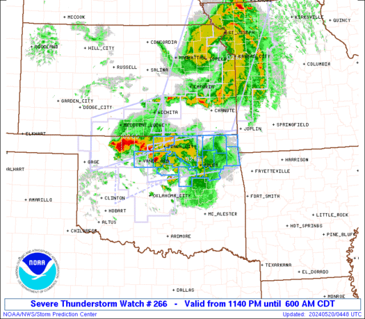
 URGENT - IMMEDIATE BROADCAST REQUESTED
Severe Thunderstorm Watch Number 266
NWS Storm Prediction Center Norman OK
1140 PM CDT Sun May 19 2024 The NWS Storm Prediction Center has issued a * Severe Thunderstorm Watch for portions of Northern into Northeast Oklahoma * Effective this Sunday night and Monday morning from 1140 PM until 600 AM CDT. * Primary threats include... Scattered large hail and isolated very large hail events to 2 inches in diameter possible Scattered damaging wind gusts to 70 mph possible SUMMARY...Scattered strong to severe thunderstorms will likely
persist tonight and gradually develop east across the Watch area. A
west to east oriented cluster of thunderstorms, occasionally
containing a supercell or two, will potentially be capable of large
hail and severe gusts. The severe thunderstorm watch area is approximately along and 35
statute miles north and south of a line from 45 miles southwest of
Ponca City OK to 5 miles east of Grove OK. For a complete depiction
of the watch see the associated watch outline update (WOUS64 KWNS
WOU6). PRECAUTIONARY/PREPAREDNESS ACTIONS... REMEMBER...A Severe Thunderstorm Watch means conditions are
favorable for severe thunderstorms in and close to the watch area.
Persons in these areas should be on the lookout for threatening
weather conditions and listen for later statements and possible
warnings. Severe thunderstorms can and occasionally do produce
tornadoes. && OTHER WATCH INFORMATION...CONTINUE...WW 262...WW 264...WW 265... AVIATION...A few severe thunderstorms with hail surface and aloft to
2 inches. Extreme turbulence and surface wind gusts to 60 knots. A
few cumulonimbi with maximum tops to 500. Mean storm motion vector
27025. ...Smith
SPC Severe Thunderstorm Watch 265 Status Reports
WW 0265 Status Updates 
 STATUS REPORT ON WW 265 THE SEVERE WEATHER THREAT CONTINUES ACROSS THE ENTIRE WATCH AREA. ..KERR..05/20/24 ATTN...WFO...DDC...ICT...OUN... STATUS REPORT FOR WS 265 SEVERE WEATHER THREAT CONTINUES FOR THE FOLLOWING AREAS KSC007-015-033-077-095-173-191-200440- KS . KANSAS COUNTIES INCLUDED ARE BARBER BUTLER COMANCHE HARPER KINGMAN SEDGWICK SUMNER OKC003-053-059-093-151-153-200440- OK . OKLAHOMA COUNTIES INCLUDED ARE ALFALFA GRANT HARPER MAJOR WOODS WOODWARD THE WATCH STATUS MESSAGE IS FOR GUIDANCE PURPOSES ONLY. PLEASE
REFER TO WATCH COUNTY NOTIFICATION STATEMENTS FOR OFFICIAL
INFORMATION ON COUNTIES...INDEPENDENT CITIES AND MARINE ZONES
CLEARED FROM SEVERE THUNDERSTORM AND TORNADO WATCHES.
SPC Severe Thunderstorm Watch 265
WW 265 SEVERE TSTM KS OK 200250Z – 200700Z
 URGENT - IMMEDIATE BROADCAST REQUESTED
Severe Thunderstorm Watch Number 265
NWS Storm Prediction Center Norman OK
950 PM CDT Sun May 19 2024 The NWS Storm Prediction Center has issued a * Severe Thunderstorm Watch for portions of South-Central Kansas Northwest Oklahoma * Effective this Sunday night and Monday morning from 950 PM until 200 AM CDT. * Primary threats include... Scattered large hail and isolated very large hail events to 2 inches in diameter possible Scattered damaging wind gusts to 70 mph possible SUMMARY...A cluster of severe thunderstorms will likely persist
through the late evening and early overnight hours as a low-level
jet remains situated over the Watch area. Large to very large hail
and severe gusts are the primary hazards with the more intense
storms. The severe thunderstorm watch area is approximately along and 50
statute miles north and south of a line from 50 miles west of Alva
OK to 25 miles southeast of Wichita KS. For a complete depiction of
the watch see the associated watch outline update (WOUS64 KWNS
WOU5). PRECAUTIONARY/PREPAREDNESS ACTIONS... REMEMBER...A Severe Thunderstorm Watch means conditions are
favorable for severe thunderstorms in and close to the watch area.
Persons in these areas should be on the lookout for threatening
weather conditions and listen for later statements and possible
warnings. Severe thunderstorms can and occasionally do produce
tornadoes. && OTHER WATCH INFORMATION...CONTINUE...WW 260...WW 262...WW
263...WW 264... AVIATION...A few severe thunderstorms with hail surface and aloft to
2 inches. Extreme turbulence and surface wind gusts to 60 knots. A
few cumulonimbi with maximum tops to 550. Mean storm motion vector
26035. ...Smith
LIVE: LARGE TORNADO CUSTER CITY, OKLAHOMA (May 19, 2024)
")
Large #tornado near Custer City, #Oklahoma #LIVE as it happened on May 19, 2024 from @TornadoSteejo Join this channel to get access to perks: https://www.youtube.com/channel/UCNPvoDpoOWevcdTHr8GyTyA/join NOT for rebroadcast or embedding. Email us at contact@texasstormchasers.com for licensing inquiries. Check out our LIVE STREAM: https://texasweather.video/ Our FREE WEATHER APP: https://texasweather.app/ Our WEBSITE/RADAR: https://www.texasstormchasers.com Our SOCIAL PLATFORMS: https://linktr.ee/texasstormchasers […]