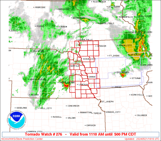
SPC PDS Tornado Watch 277

WW 277 TORNADO IA IL MN WI 211810Z – 220200Z
WW 0277 Image

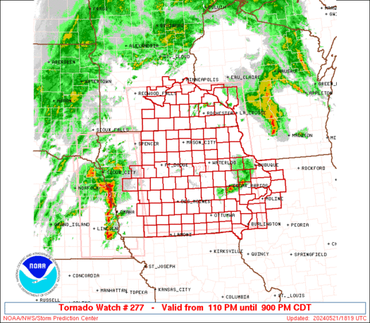
 URGENT - IMMEDIATE BROADCAST REQUESTED
Tornado Watch Number 277
NWS Storm Prediction Center Norman OK
110 PM CDT Tue May 21 2024 The NWS Storm Prediction Center has issued a * Tornado Watch for portions of Iowa Northwest Illinois Southeast Minnesota Western Wisconsin * Effective this Tuesday afternoon and evening from 110 PM until 900 PM CDT. ...THIS IS A PARTICULARLY DANGEROUS SITUATION... * Primary threats include... Several tornadoes and a few intense tornadoes likely Widespread damaging winds and isolated significant gusts to 90 mph likely Scattered large hail likely with isolated very large hail events to 4 inches in diameter possible SUMMARY...An increasingly volatile environment and very strong
atmospheric winds are expected to yield an outbreak of severe storms
including tornadoes and widespread damaging winds across the region
through the afternoon and early evening. The tornado watch area is approximately along and 110 statute miles
east and west of a line from 30 miles south southwest of Ottumwa IA
to 50 miles northeast of Mankato MN. For a complete depiction of the
watch see the associated watch outline update (WOUS64 KWNS WOU7). PRECAUTIONARY/PREPAREDNESS ACTIONS... REMEMBER...A Tornado Watch means conditions are favorable for
tornadoes and severe thunderstorms in and close to the watch
area. Persons in these areas should be on the lookout for
threatening weather conditions and listen for later statements
and possible warnings. && OTHER WATCH INFORMATION...CONTINUE...WW 276... AVIATION...Tornadoes and a few severe thunderstorms with hail
surface and aloft to 4 inches. Extreme turbulence and surface wind
gusts to 80 knots. A few cumulonimbi with maximum tops to 500. Mean
storm motion vector 22045. ...Guyer 

Read more

SPC Tornado Watch 276

WW 276 TORNADO IA MO NE SD 211610Z – 212200Z
WW 0276 Image

 URGENT - IMMEDIATE BROADCAST REQUESTED
Tornado Watch Number 276
NWS Storm Prediction Center Norman OK
1110 AM CDT Tue May 21 2024 The NWS Storm Prediction Center has issued a * Tornado Watch for portions of Western Iowa Northwest Missouri Eastern Nebraska Southeast South Dakota * Effective this Tuesday morning and afternoon from 1110 AM until 500 PM CDT. * Primary threats include... A few tornadoes and a couple intense tornadoes possible Scattered large hail likely with isolated very large hail events to 3 inches in diameter possible Scattered damaging wind gusts to 70 mph likely SUMMARY...The atmosphere is expected to rapidly become favorable for
severe storm development, including the potential for tornadoes,
through early/mid-afternoon. The tornado watch area is approximately along and 60 statute miles
east and west of a line from 55 miles west northwest of Spencer IA
to 25 miles west of Falls City NE. For a complete depiction of the
watch see the associated watch outline update (WOUS64 KWNS WOU6). PRECAUTIONARY/PREPAREDNESS ACTIONS... REMEMBER...A Tornado Watch means conditions are favorable for
tornadoes and severe thunderstorms in and close to the watch
area. Persons in these areas should be on the lookout for
threatening weather conditions and listen for later statements
and possible warnings. && OTHER WATCH INFORMATION...CONTINUE...WW 275... AVIATION...Tornadoes and a few severe thunderstorms with hail
surface and aloft to 3 inches. Extreme turbulence and surface wind
gusts to 60 knots. A few cumulonimbi with maximum tops to 500. Mean
storm motion vector 22035. ...Guyer 

Read more

SPC Severe Thunderstorm Watch 275

WW 275 SEVERE TSTM IA 211115Z – 211800Z
WW 0275 Image

 URGENT - IMMEDIATE BROADCAST REQUESTED
Severe Thunderstorm Watch Number 275
NWS Storm Prediction Center Norman OK
615 AM CDT Tue May 21 2024 The NWS Storm Prediction Center has issued a * Severe Thunderstorm Watch for portions of Central and southern Iowa * Effective this Tuesday morning and afternoon from 615 AM until 100 PM CDT. * Primary threats include... Scattered damaging winds and isolated significant gusts to 75 mph possible Isolated large hail events to 1.5 inches in diameter possible A tornado or two possible SUMMARY...Clusters of thunderstorms -- including an organized bowing
complex initially over eastern NE -- will pose a threat mainly for
severe gusts while crossing the watch area from west to east. A
tornado or two cannot be ruled out, especially near an outflow
boundary draped across central/south-central IA. Isolated large
hail is possible. This is a precursor to the main severe-weather
threat expected later today, for which we have a "Moderate Risk"
outlook. The severe thunderstorm watch area is approximately along and 60
statute miles north and south of a line from 80 miles west of Des
Moines IA to 25 miles south southeast of Cedar Rapids IA. For a
complete depiction of the watch see the associated watch outline
update (WOUS64 KWNS WOU5). PRECAUTIONARY/PREPAREDNESS ACTIONS... REMEMBER...A Severe Thunderstorm Watch means conditions are
favorable for severe thunderstorms in and close to the watch area.
Persons in these areas should be on the lookout for threatening
weather conditions and listen for later statements and possible
warnings. Severe thunderstorms can and occasionally do produce
tornadoes. && OTHER WATCH INFORMATION...CONTINUE...WW 274... AVIATION...A few severe thunderstorms with hail surface and aloft to
1.5 inches. Extreme turbulence and surface wind gusts to 65 knots. A
few cumulonimbi with maximum tops to 550. Mean storm motion vector
26045. ...Edwards 

Read more